
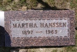
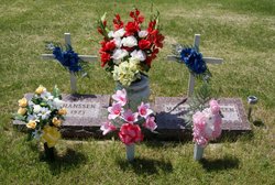
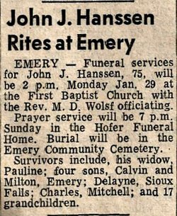
Martha Lang Hanssen
| Birth | : | 18 Jun 1897 Clayton, Hutchinson County, South Dakota, USA |
| Death | : | 28 Apr 1965 |
| Burial | : | Woodlawn Cemetery, Vermontville, Eaton County, USA |
| Coordinate | : | 42.6363983, -85.0547028 |
| Description | : | Wife of John J. Hanssen. |
frequently asked questions (FAQ):
-
Where is Martha Lang Hanssen's memorial?
Martha Lang Hanssen's memorial is located at: Woodlawn Cemetery, Vermontville, Eaton County, USA.
-
When did Martha Lang Hanssen death?
Martha Lang Hanssen death on 28 Apr 1965 in
-
Where are the coordinates of the Martha Lang Hanssen's memorial?
Latitude: 42.6363983
Longitude: -85.0547028
Family Members:
Parent
Spouse
Siblings


Flowers:


Nearby Cemetories:
1. Woodlawn Cemetery
Vermontville, Eaton County, USA
Coordinate: 42.6363983, -85.0547028
2. Patterson Cemetery
Vermontville, Eaton County, USA
Coordinate: 42.6652985, -85.0327988
3. Hosmer Cemetery
Nashville, Barry County, USA
Coordinate: 42.6380997, -85.1038971
4. Lakeview Cemetery
Nashville, Barry County, USA
Coordinate: 42.5986099, -85.0845566
5. Hager Cemetery
Kalamo, Eaton County, USA
Coordinate: 42.6844440, -85.0683330
6. Ames Cemetery
Vermontville, Eaton County, USA
Coordinate: 42.6411018, -84.9741974
7. Freemire Cemetery
Sunfield, Eaton County, USA
Coordinate: 42.6852989, -84.9961014
8. Mason Cemetery
Kalamo Township, Eaton County, USA
Coordinate: 42.5669440, -85.0508330
9. Dillon Family Farm Cemetery
Maple Grove Township, Barry County, USA
Coordinate: 42.5726400, -85.0924800
10. Coats Grove Cemetery
Coats Grove, Barry County, USA
Coordinate: 42.6833350, -85.1282930
11. Rest Haven Cemetery
Charlotte, Eaton County, USA
Coordinate: 42.6217420, -84.9563380
12. Stoney Point Cemetery
Nashville, Barry County, USA
Coordinate: 42.6539600, -85.1534800
13. Cogsdill Cemetery
Kalamo, Eaton County, USA
Coordinate: 42.5817470, -84.9747850
14. Woodland Memorial Park
Woodland, Barry County, USA
Coordinate: 42.7043991, -85.1153030
15. German Evangelical Cemetery
Maple Grove Township, Barry County, USA
Coordinate: 42.5813900, -85.1431400
16. Barryville Cemetery
Nashville, Barry County, USA
Coordinate: 42.6039810, -85.1725922
17. Hillside Cemetery
Kalamo, Eaton County, USA
Coordinate: 42.5462500, -85.0138100
18. Welch Cemetery
Sunfield, Eaton County, USA
Coordinate: 42.7174988, -84.9766998
19. Sunfield Cemetery
Sunfield, Eaton County, USA
Coordinate: 42.7277985, -84.9907990
20. Wilcox Cemetery
Nashville, Barry County, USA
Coordinate: 42.5388870, -85.1216660
21. Quaker Cemetery
Maple Grove Township, Barry County, USA
Coordinate: 42.5311012, -85.1102982
22. Gresham Cemetery
Chester Township, Eaton County, USA
Coordinate: 42.6278000, -84.8938980
23. West Carmel Cemetery
Charlotte, Eaton County, USA
Coordinate: 42.5540300, -84.9359900
24. Moyer Cemetery
Roxand Township, Eaton County, USA
Coordinate: 42.6919160, -84.8958020