
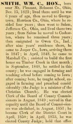
| Birth | : | 1838 |
| Death | : | 1864 |
| Burial | : | Mountain View Cemetery, Deming, Luna County, USA |
| Coordinate | : | 32.2677994, -107.7193985 |
frequently asked questions (FAQ):
-
Where is Martha Smith's memorial?
Martha Smith's memorial is located at: Mountain View Cemetery, Deming, Luna County, USA.
-
When did Martha Smith death?
Martha Smith death on 1864 in
-
Where are the coordinates of the Martha Smith's memorial?
Latitude: 32.2677994
Longitude: -107.7193985
Family Members:
Parent
Spouse

Siblings
Children
Flowers:


Nearby Cemetories:
1. Mountain View Cemetery
Deming, Luna County, USA
Coordinate: 32.2677994, -107.7193985
2. Louise Coffman Memorial Park
Deming, Luna County, USA
Coordinate: 32.2524000, -107.7145000
3. Desert Lawn Memorial Gardens
Deming, Luna County, USA
Coordinate: 32.3084000, -107.7818000
4. Holy Cross Cemetery
Luna County, USA
Coordinate: 32.2789001, -107.8056030
5. Lewis Flats Cemetery
Deming, Luna County, USA
Coordinate: 32.2313995, -107.5710983
6. Fort Cummings Cemetery
Luna County, USA
Coordinate: 32.4618988, -107.6391983
7. Carroll Cemetery
Luna County, USA
Coordinate: 32.0522003, -107.8855972
8. Cooks Peak Cemetery
Luna County, USA
Coordinate: 32.5564003, -107.7181015
9. Foster Cemetery
Luna County, USA
Coordinate: 32.5862410, -107.9062660
10. Coleson's Crossing Cemetery
Dwyer, Grant County, USA
Coordinate: 32.5682540, -107.9522090
11. Dwyer Cemetery
Dwyer, Grant County, USA
Coordinate: 32.6231600, -107.8792400
12. Valley Heights Cemetery
Columbus, Luna County, USA
Coordinate: 31.8365820, -107.6624970
13. Lake Valley Cemetery
Lake Valley, Sierra County, USA
Coordinate: 32.7132988, -107.5640030
14. Nunn Ranch Cemetery
Sierra County, USA
Coordinate: 32.7410000, -107.6133000
15. Perrault Ranch Cemetery
Sherman, Grant County, USA
Coordinate: 32.7493770, -107.8935000
16. Panteón de Puerto Palomas
Puerto Palomas, Ascensión Municipality, Mexico
Coordinate: 31.7635810, -107.6276950
17. San Juan Catholic Cemetery
Grant County, USA
Coordinate: 32.7647705, -107.9098969
18. Victorio Cemetery
Luna County, USA
Coordinate: 31.8511500, -108.1384000
19. Hurley Cemetery
Hurley, Grant County, USA
Coordinate: 32.6885986, -108.1363983
20. San Lorenzo Cemetery
San Lorenzo, Grant County, USA
Coordinate: 32.7910270, -107.9205040
21. Tierra Blanca Cemetery
Sierra County, USA
Coordinate: 32.8408000, -107.6540000
22. Bayard Cemetery
Bayard, Grant County, USA
Coordinate: 32.7403620, -108.1326270
23. Garden of Memories
Hatch, Doña Ana County, USA
Coordinate: 32.6539001, -107.1847000
24. Gustava Glaze Gravesite
Grant County, USA
Coordinate: 32.5309240, -108.3568690