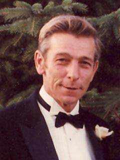
Martin C. Kunkel
| Birth | : | 8 Mar 1937 Haverhill, Marshall County, Iowa, USA |
| Death | : | 21 Nov 2006 Baxter, Jasper County, Iowa, USA |
| Burial | : | Greengrove Saint Peters Cemetery, Greengrove, Central Coast Council, Australia |
| Coordinate | : | -33.3803020, 151.1400300 |
| Description | : | Martin C. Kunkel died Tuesday, November 21, 2006, the fourth child of Martin B. and Eva M. (Resch) Kunkel, he was born on the eighth day of March 1937 in Haverhill, Iowa. He was preceded in death by his father and mother, brother Richard Kunkel and his sister, Joanne Grout. He is survived by his wife Jane; oldest son and family, Daniel, Colette, Alexandria and Elizabeth of Baxter; second son and grandson, Dewey and Brandon of Baxter; daughter and family, Deanna, Court, Eva, Daniel and Christian Garloff of Center Point; third son and family, Martin, JoAnne and Lea of... Read More |
frequently asked questions (FAQ):
-
Where is Martin C. Kunkel's memorial?
Martin C. Kunkel's memorial is located at: Greengrove Saint Peters Cemetery, Greengrove, Central Coast Council, Australia.
-
When did Martin C. Kunkel death?
Martin C. Kunkel death on 21 Nov 2006 in Baxter, Jasper County, Iowa, USA
-
Where are the coordinates of the Martin C. Kunkel's memorial?
Latitude: -33.3803020
Longitude: 151.1400300
Family Members:
Parent
Siblings
Flowers:
Nearby Cemetories:
1. Greengrove Saint Peters Cemetery
Greengrove, Central Coast Council, Australia
Coordinate: -33.3803020, 151.1400300
2. Maloney Gravesite
Glenworth Valley, Central Coast Council, Australia
Coordinate: -33.4039645, 151.1957958
3. Holy Trinity Church Cemetery
Spencer, Central Coast Council, Australia
Coordinate: -33.4293910, 151.1639380
4. Upper Mangrove Saint Thomas Anglican
Upper Mangrove Creek, Central Coast Council, Australia
Coordinate: -33.3108330, 151.1296840
5. Books Ferry Catholic Cemetery
Saint Albans, Hawkesbury City, Australia
Coordinate: -33.3459720, 150.9793550
6. Central MacDonald Cemetery
Central MacDonald, Hawkesbury City, Australia
Coordinate: -33.3417800, 150.9797400
7. St. Jude's Cemetery
Hawkesbury City, Australia
Coordinate: -33.3355756, 150.9761062
8. St Jude's Anglican Cemetery
Central MacDonald, Hawkesbury City, Australia
Coordinate: -33.3272290, 150.9780090
9. Bar Island Cemetery
Hornsby Shire, Australia
Coordinate: -33.5262140, 151.1528610
10. Saint Albans Old Cemetery
Saint Albans, Hawkesbury City, Australia
Coordinate: -33.3045550, 150.9824300
11. Point Clare Cemetery
Point Clare, Central Coast Council, Australia
Coordinate: -33.4344800, 151.3128600
12. Frances Peat Lone Grave
Mooney Mooney, Central Coast Council, Australia
Coordinate: -33.5333171, 151.1989208
13. Brooklyn General Cemetery
Brooklyn, Hornsby Shire, Australia
Coordinate: -33.5471710, 151.1990020
14. Saint Albans New Cemetery
Saint Albans, Hawkesbury City, Australia
Coordinate: -33.2805930, 150.9687760
15. Bailey Family Cemetery on the Glen
Saint Albans, Hawkesbury City, Australia
Coordinate: -33.2757030, 150.9704900
16. Helys Grave
Wyoming, Central Coast Council, Australia
Coordinate: -33.4031120, 151.3505420
17. Bradys Gully Cemetery
Gosford, Central Coast Council, Australia
Coordinate: -33.4168700, 151.3492720
18. Point Frederick Pioneer Cemetery
Point Frederick, Central Coast Council, Australia
Coordinate: -33.4498830, 151.3417900
19. Loretto Catholic Cemetery
Saint Albans, Hawkesbury City, Australia
Coordinate: -33.2629320, 150.9676510
20. Lisarow Cemetery
Lisarow, Central Coast Council, Australia
Coordinate: -33.3761970, 151.3747470
21. Yarramalong Saint Barnabas
Yarramalong, Central Coast Council, Australia
Coordinate: -33.2189900, 151.2755430
22. Veteran Hall
Saratoga, Central Coast Council, Australia
Coordinate: -33.4786400, 151.3452750
23. Yarramalong Cemetery
Yarramalong, Central Coast Council, Australia
Coordinate: -33.2263180, 151.2881020
24. Palmdale Lawn Cemetery & Memorial Park
Palmdale, Central Coast Council, Australia
Coordinate: -33.3315580, 151.3750700


