
| Birth | : | 15 Dec 1852 Fredericktown, Madison County, Missouri, USA |
| Death | : | 29 Nov 1926 Cape Girardeau, Cape Girardeau County, Missouri, USA |
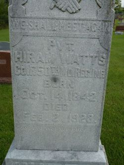
| Burial | : | Myers Cemetery, Glenallen, Bollinger County, USA |
| Coordinate | : | 37.3171997, -90.0096970 |
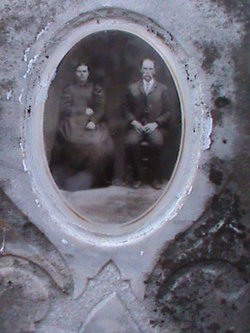
| Description | : | Daughter of Jim Watts and Louise (Berry) Watts. Married Henry B. Baker 24/Apr/1878 at Madison Co., MO. Per MO Death certificate #34219, burial 01/Dec/1926. A suggestion was received that her middle name is Amelia, after her grandmother. No source was included, this has not been verified. |
frequently asked questions (FAQ):
-
Where is Mary A. Watts Baker's memorial?
Mary A. Watts Baker's memorial is located at: Myers Cemetery, Glenallen, Bollinger County, USA.
-
When did Mary A. Watts Baker death?
Mary A. Watts Baker death on 29 Nov 1926 in Cape Girardeau, Cape Girardeau County, Missouri, USA
-
Where are the coordinates of the Mary A. Watts Baker's memorial?
Latitude: 37.3171997
Longitude: -90.0096970
Family Members:
Parent

Spouse
Siblings
Children
Flowers:


Nearby Cemetories:
1. Myers Cemetery
Glenallen, Bollinger County, USA
Coordinate: 37.3171997, -90.0096970
2. Lower Deck Cemetery
Lutesville, Bollinger County, USA
Coordinate: 37.3078003, -90.0119019
3. Glen Allen Cemetery
Glenallen, Bollinger County, USA
Coordinate: 37.3201100, -90.0320100
4. Slaybaugh Cemetery
Lutesville, Bollinger County, USA
Coordinate: 37.2982150, -89.9851870
5. El Nathan Cemetery
Marble Hill, Bollinger County, USA
Coordinate: 37.3086710, -89.9757960
6. Upper Deck Cemetery
Glenallen, Bollinger County, USA
Coordinate: 37.3236008, -90.0444031
7. Buehler Cemetery
Glenallen, Bollinger County, USA
Coordinate: 37.3466988, -89.9989014
8. Marble Hill Cemetery
Marble Hill, Bollinger County, USA
Coordinate: 37.3032799, -89.9701309
9. Hahn Cemetery
Lutesville, Bollinger County, USA
Coordinate: 37.2886009, -89.9772034
10. Shell Cemetery
Lutesville, Bollinger County, USA
Coordinate: 37.2839012, -89.9693985
11. Baker Cemetery
Marble Hill, Bollinger County, USA
Coordinate: 37.2722015, -89.9869003
12. Hahn Chapel Cemetery
Marble Hill, Bollinger County, USA
Coordinate: 37.3061638, -89.9492645
13. Bollinger County Memorial Park Cemetery
Marble Hill, Bollinger County, USA
Coordinate: 37.2689018, -89.9871979
14. Dry Creek Cemetery
Lutesville, Bollinger County, USA
Coordinate: 37.2675018, -90.0291977
15. Shrum Cemetery
Hurricane, Bollinger County, USA
Coordinate: 37.3751500, -90.0144800
16. Barks Cemetery
Marble Hill, Bollinger County, USA
Coordinate: 37.3506012, -89.9494019
17. Eaker Cemetery
Lutesville, Bollinger County, USA
Coordinate: 37.2778015, -89.9516983
18. Wallis Cemetery
Hurricane, Bollinger County, USA
Coordinate: 37.3800011, -90.0081024
19. Burton Cemetery
Marble Hill, Bollinger County, USA
Coordinate: 37.3722000, -89.9697037
20. Bess Cemetery
Hurricane, Bollinger County, USA
Coordinate: 37.3807983, -89.9927979
21. Patterson Family Cemetery
Bollinger County, USA
Coordinate: 37.2511100, -90.0107100
22. Shelton Cemetery
Huxie, Bollinger County, USA
Coordinate: 37.2556000, -90.0481033
23. McMahan Cemetery
Bessville, Bollinger County, USA
Coordinate: 37.3767014, -90.0597000
24. Formway Cemetery
Bollinger County, USA
Coordinate: 37.3166900, -89.9165400