
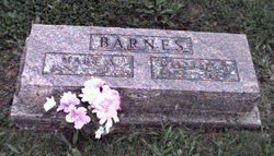

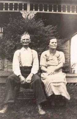
Mary Agnes Snapp Barnes
| Birth | : | 10 Aug 1885 Rosewood, Champaign County, Ohio, USA |
| Death | : | 23 Aug 1975 Decatur, Adams County, Indiana, USA |
| Burial | : | Barton-Upon-Humber Cemetery, Barton-upon-Humber, North Lincolnshire Unitary Authority, England |
| Coordinate | : | 53.6817370, -0.4279560 |
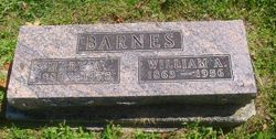
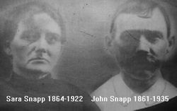
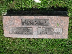
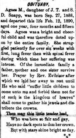
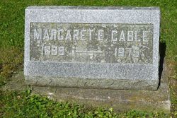
| Description | : | MARY A. BARNES Mary A. Barnes, 90, Decatur, Ind., died in her home at 3:45 a.m. Aug. 23. She was born in Rosewood on Aug. 10, 1885, a daughter of Thomas and Sarah Corbett Snapp. She lived in this county most of her life. She married William Barnes on June 18, 1905. Survivors include one son, Harry Barnes of 137 E. Ward St.; Mrs. John Pokorny of Decatur, Ind.; eight grandchildren, 23 great-grandchildren and three great-great grandchildren; one brother Tullie Snapp of Fletcher and one sister, Margaret Cable of Colorado. Her husband and one son preceded... Read More |
frequently asked questions (FAQ):
-
Where is Mary Agnes Snapp Barnes's memorial?
Mary Agnes Snapp Barnes's memorial is located at: Barton-Upon-Humber Cemetery, Barton-upon-Humber, North Lincolnshire Unitary Authority, England.
-
When did Mary Agnes Snapp Barnes death?
Mary Agnes Snapp Barnes death on 23 Aug 1975 in Decatur, Adams County, Indiana, USA
-
Where are the coordinates of the Mary Agnes Snapp Barnes's memorial?
Latitude: 53.6817370
Longitude: -0.4279560
Family Members:
Parent
Spouse
Siblings
Children
Flowers:


Nearby Cemetories:
1. Barton-Upon-Humber Cemetery
Barton-upon-Humber, North Lincolnshire Unitary Authority, England
Coordinate: 53.6817370, -0.4279560
2. Barton-upon-Humber Old Cemetery
Barton-upon-Humber, North Lincolnshire Unitary Authority, England
Coordinate: 53.6818650, -0.4284450
3. St Mary's Churchyard
Barton-upon-Humber, North Lincolnshire Unitary Authority, England
Coordinate: 53.6844300, -0.4367800
4. Holy Trinity Churchyard
Barrow upon Humber, North Lincolnshire Unitary Authority, England
Coordinate: 53.6783720, -0.3787880
5. Barrow-Upon-Humber Cemetery
Barrow upon Humber, North Lincolnshire Unitary Authority, England
Coordinate: 53.6678740, -0.3755040
6. All Saints Churchyard
Hessle, East Riding of Yorkshire Unitary Authority, England
Coordinate: 53.7240270, -0.4358490
7. Hessle Cemetery
Hessle, East Riding of Yorkshire Unitary Authority, England
Coordinate: 53.7270800, -0.4379100
8. St Nicholas Churchyard
South Ferriby, North Lincolnshire Unitary Authority, England
Coordinate: 53.6746420, -0.5051450
9. St Maurice Churchyard
Horkstow, North Lincolnshire Unitary Authority, England
Coordinate: 53.6512040, -0.5079660
10. All Saints Churchyard
Goxhill, North Lincolnshire Unitary Authority, England
Coordinate: 53.6759810, -0.3329040
11. Goxhill Cemetery
Goxhill, North Lincolnshire Unitary Authority, England
Coordinate: 53.6798690, -0.3246480
12. Anlaby Cemetery
Anlaby, East Riding of Yorkshire Unitary Authority, England
Coordinate: 53.7413000, -0.4550700
13. All Saints' Churchyard
Saxby-All-Saints, North Lincolnshire Unitary Authority, England
Coordinate: 53.6372500, -0.5010260
14. St Andrew Churchyard
Bonby, North Lincolnshire Unitary Authority, England
Coordinate: 53.6266000, -0.4838000
15. St Peter Churchyard
Anlaby, East Riding of Yorkshire Unitary Authority, England
Coordinate: 53.7460700, -0.4343620
16. Division Road Cemetery
Kingston upon Hull, Kingston upon Hull Unitary Authority, England
Coordinate: 53.7358194, -0.3679444
17. St Andrew's Churchyard
Wootton, North Lincolnshire Unitary Authority, England
Coordinate: 53.6306857, -0.3549418
18. Mill Lane Cemetery
Kirk Ella, East Riding of Yorkshire Unitary Authority, England
Coordinate: 53.7473720, -0.4519410
19. Hessle Road Jewish Cemetery
Kingston upon Hull, Kingston upon Hull Unitary Authority, England
Coordinate: 53.7374970, -0.3533980
20. St. Clement's Churchyard
Worlaby, North Lincolnshire Unitary Authority, England
Coordinate: 53.6129220, -0.4667760
21. Villa Place Jewish Cemetery
Kingston upon Hull, Kingston upon Hull Unitary Authority, England
Coordinate: 53.7396530, -0.3516970
22. St Andrew Churchyard
Kirk Ella, East Riding of Yorkshire Unitary Authority, England
Coordinate: 53.7538430, -0.4542050
23. Thornton Abbey
Thornton Curtis, North Lincolnshire Unitary Authority, England
Coordinate: 53.6550000, -0.3098000
24. Western Cemetery
Kingston upon Hull, Kingston upon Hull Unitary Authority, England
Coordinate: 53.7516700, -0.3727100