Mary Ann Dyer Manning
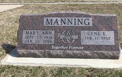
| Birth | : | 25 Sep 1931 Emporia, Lyon County, Kansas, USA |
| Death | : | 22 Jan 2014 Kansas, USA |
| Burial | : | Whitewater Cemetery, Harvey County, USA |
| Coordinate | : | 37.9550018, -97.1699982 |
| Description | : | Manning, Mary Ann (Dyer), 82, of Newton formerly of El Dorado went home to her Lord on January 22, 2014. Memorial service will take place Monday January 27, 2014 at the First Christian Church in El Dorado at 10 AM. Pastor Stan Seymour will be presiding. Burial will follow at Whitewater Cemetery in Whitewater, KS. Mary Ann was born on September 25, 1931 the daughter of Ernest and Ethel Dyer in Emporia, KS. She graduated from Emporia High School in 1950 then attended Ottawa University. On May 9, 1954, she married Gene E. Manning in Emporia. She retired from the... Read More |
frequently asked questions (FAQ):
-
Where is Mary Ann Dyer Manning's memorial?
Mary Ann Dyer Manning's memorial is located at: Whitewater Cemetery, Harvey County, USA.
-
When did Mary Ann Dyer Manning death?
Mary Ann Dyer Manning death on 22 Jan 2014 in Kansas, USA
-
Where are the coordinates of the Mary Ann Dyer Manning's memorial?
Latitude: 37.9550018
Longitude: -97.1699982
Family Members:
Flowers:
Nearby Cemetories:
1. Whitewater Cemetery
Harvey County, USA
Coordinate: 37.9550018, -97.1699982
2. Swiss Cemetery
Whitewater, Butler County, USA
Coordinate: 37.9799995, -97.1343994
3. Harder Cemetery
Brainerd, Butler County, USA
Coordinate: 37.9593800, -97.1161600
4. Emmaus Mennonite Church South Cemetery
Brainerd, Butler County, USA
Coordinate: 37.9569000, -97.0951000
5. Old Grace Hill Mennonite Church Cemetery
Harvey County, USA
Coordinate: 38.0128870, -97.1859870
6. Brainerd Cemetery
Brainerd, Butler County, USA
Coordinate: 37.9566994, -97.0932999
7. Joseph Golden Gravesite
Annelly, Harvey County, USA
Coordinate: 37.9698700, -97.2456600
8. Emmaus Mennonite Church Cemetery
Whitewater, Butler County, USA
Coordinate: 37.9855200, -97.0989400
9. Green Valley Cemetery
Furley, Sedgwick County, USA
Coordinate: 37.8842010, -97.1694031
10. Grace Hill Mennonite Church Cemetery
Harvey County, USA
Coordinate: 38.0289800, -97.1803300
11. Horace Hayes Gravesite
Newton, Harvey County, USA
Coordinate: 38.0435950, -97.1757810
12. Missionary Church Cemetery
Harvey County, USA
Coordinate: 38.0581017, -97.1622009
13. Pleasant View Cemetery
Elbing, Butler County, USA
Coordinate: 38.0499992, -97.1153030
14. Shafer Cemetery
Potwin, Butler County, USA
Coordinate: 37.9075012, -97.0483017
15. Adams Family Cemetery
Butler County, USA
Coordinate: 37.9850311, -97.0330963
16. Potwin Cemetery
Potwin, Butler County, USA
Coordinate: 37.9423027, -97.0250702
17. Lorraine Avenue Mennonite Church Cemetery
Valley Center, Sedgwick County, USA
Coordinate: 37.8408012, -97.1977997
18. Fairmount Lonestar Cemetery
Butler County, USA
Coordinate: 38.0285500, -97.0514200
19. McGill Cemetery
Potwin, Butler County, USA
Coordinate: 37.9188995, -97.0246964
20. Harvey County Memorial
Newton, Harvey County, USA
Coordinate: 38.0716090, -97.2184190
21. Union Cemetery
Benton, Butler County, USA
Coordinate: 37.8314018, -97.1331024
22. Zion Cemetery
Elbing, Butler County, USA
Coordinate: 38.0783005, -97.1160965
23. Haldeman Cemetery
Butler County, USA
Coordinate: 37.9989014, -97.0132980
24. 101 Club Cemetery
Valley Center, Sedgwick County, USA
Coordinate: 37.8697132, -97.3141009


