

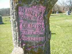
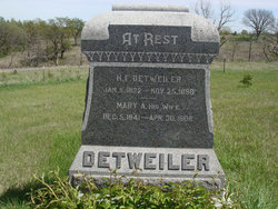
Mary Ann Hillyer Detweiler
| Birth | : | 5 Dec 1841 Pennsylvania, USA |
| Death | : | 30 Apr 1906 Saint Bridget, Marshall County, Kansas, USA |
| Burial | : | Shockleys Fairland Cemetery, Marshall County, USA |
| Coordinate | : | 39.9284500, -96.2866500 |
frequently asked questions (FAQ):
-
Where is Mary Ann Hillyer Detweiler's memorial?
Mary Ann Hillyer Detweiler's memorial is located at: Shockleys Fairland Cemetery, Marshall County, USA.
-
When did Mary Ann Hillyer Detweiler death?
Mary Ann Hillyer Detweiler death on 30 Apr 1906 in Saint Bridget, Marshall County, Kansas, USA
-
Where are the coordinates of the Mary Ann Hillyer Detweiler's memorial?
Latitude: 39.9284500
Longitude: -96.2866500
Family Members:
Parent
Spouse
Siblings

Children

Flowers:


Nearby Cemetories:
1. Shockleys Fairland Cemetery
Marshall County, USA
Coordinate: 39.9284500, -96.2866500
2. Saint Bridget Cemetery
Axtell, Marshall County, USA
Coordinate: 39.9572000, -96.2578000
3. Saint Michaels Cemetery
Axtell, Marshall County, USA
Coordinate: 39.8922005, -96.2577972
4. Rose Hill Cemetery
Axtell, Marshall County, USA
Coordinate: 39.8793983, -96.2667007
5. Madden Cemetery
Axtell, Marshall County, USA
Coordinate: 39.9866800, -96.2490300
6. Ash Point Cemetery
Baileyville, Nemaha County, USA
Coordinate: 39.8962380, -96.2051080
7. Holy Family Cemetery
Summerfield, Marshall County, USA
Coordinate: 39.9994011, -96.3414001
8. Summerfield Cemetery
Summerfield, Marshall County, USA
Coordinate: 40.0005989, -96.3422012
9. Brewer Cemetery
Baileyville, Nemaha County, USA
Coordinate: 39.9556900, -96.1736500
10. Richland Center Cemetery
Marshall County, USA
Coordinate: 39.9584000, -96.4073700
11. Guittard Cemetery
Beattie, Marshall County, USA
Coordinate: 39.9094009, -96.4152985
12. Johnson Creek Cemetery
Pawnee City, Pawnee County, USA
Coordinate: 40.0270000, -96.2465000
13. Mission Covenant Cemetery
Marshall County, USA
Coordinate: 39.8269005, -96.3153000
14. Baileyville Cemetery
Baileyville, Nemaha County, USA
Coordinate: 39.8418900, -96.1976300
15. Sacred Heart Cemetery
Baileyville, Nemaha County, USA
Coordinate: 39.8485985, -96.1832962
16. Beattie Union Cemetery
Beattie, Marshall County, USA
Coordinate: 39.8717003, -96.4207993
17. McCaffrey Cemetery
Nemaha County, USA
Coordinate: 39.9827100, -96.1474500
18. Saint Patricks Cemetery
Beattie, Marshall County, USA
Coordinate: 39.8703003, -96.4231033
19. Salem Lutheran Cemetery
Axtell, Marshall County, USA
Coordinate: 39.7990200, -96.3352200
20. Pleasant Ridge Cemetery
Du Bois, Pawnee County, USA
Coordinate: 40.0156000, -96.1494000
21. Tanner Cemetery
Pawnee County, USA
Coordinate: 40.0238991, -96.4143982
22. Mission Creek Cemetery
Pawnee County, USA
Coordinate: 40.0149994, -96.4263992
23. Pleasant Valley Cemetery
Pawnee County, USA
Coordinate: 40.0299988, -96.1554794
24. Mission Creek Cemetery
Marshall County, USA
Coordinate: 39.9866982, -96.4649963