
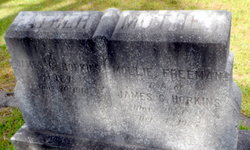
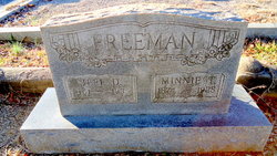
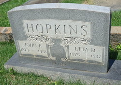
Mary Ann “Mollie” Freeman Hopkins
| Birth | : | 29 Mar 1841 Anderson County, South Carolina, USA |
| Death | : | 4 Oct 1927 Anderson, Anderson County, South Carolina, USA |
| Burial | : | Riverside Cemetery, Washburn, Aroostook County, USA |
| Coordinate | : | 46.7785492, -68.1552277 |
frequently asked questions (FAQ):
-
Where is Mary Ann “Mollie” Freeman Hopkins's memorial?
Mary Ann “Mollie” Freeman Hopkins's memorial is located at: Riverside Cemetery, Washburn, Aroostook County, USA.
-
When did Mary Ann “Mollie” Freeman Hopkins death?
Mary Ann “Mollie” Freeman Hopkins death on 4 Oct 1927 in Anderson, Anderson County, South Carolina, USA
-
Where are the coordinates of the Mary Ann “Mollie” Freeman Hopkins's memorial?
Latitude: 46.7785492
Longitude: -68.1552277
Family Members:
Parent

Spouse

Siblings
Children
Flowers:

Left by Anonymous on 15 Feb 2011

Her death certificate identifies her as Mollie Anne Hopkins, she was a widow, informant was J.P. Hopkins. She had fallen and broken her hip, she was also senile. Lived at Ligon St. Anderson SC. She was 88y
Left by Anonymous on 04 Sep 2012

In memory of my second Great Aunt.
Left by Anonymous on 11 Jun 2016
Left by Anonymous on 15 Feb 2011
Her death certificate identifies her as Mollie Anne Hopkins, she was a widow, informant was J.P. Hopkins. She had fallen and broken her hip, she was also senile. Lived at Ligon St. Anderson SC. She was 88y
Left by Anonymous on 04 Sep 2012
In memory of my second Great Aunt.
Left by Anonymous on 11 Jun 2016


Nearby Cemetories:
1. Riverside Cemetery
Washburn, Aroostook County, USA
Coordinate: 46.7785492, -68.1552277
2. Washburn Riverside Extension Cemetery
Washburn, Aroostook County, USA
Coordinate: 46.7750816, -68.1517105
3. Castle Hill Cemetery
Castle Hill, Aroostook County, USA
Coordinate: 46.7346840, -68.1792210
4. Crouseville Cemetery
Crouseville, Aroostook County, USA
Coordinate: 46.7574997, -68.0768967
5. Hillside Grove Cemetery
Crouseville, Aroostook County, USA
Coordinate: 46.7566760, -68.0765500
6. Fairview Cemetery
Perham, Aroostook County, USA
Coordinate: 46.8666992, -68.2086029
7. Old Mill Town Cemetery
Mapleton, Aroostook County, USA
Coordinate: 46.6815700, -68.1609100
8. Northern Maine Veterans Cemetery
Caribou, Aroostook County, USA
Coordinate: 46.8512400, -68.0428500
9. Lyndon Center Cemetery
Caribou, Aroostook County, USA
Coordinate: 46.8022240, -67.9921920
10. Southside Cemetery
Mapleton, Aroostook County, USA
Coordinate: 46.6622050, -68.1633620
11. Tarr Cemetery
Castle Hill, Aroostook County, USA
Coordinate: 46.6664200, -68.2203800
12. Evergreen Cemetery
Caribou, Aroostook County, USA
Coordinate: 46.8524500, -68.0112700
13. Johnson Cemetery
Presque Isle, Aroostook County, USA
Coordinate: 46.7078209, -68.0069733
14. Thompson Burial Ground
Caribou, Aroostook County, USA
Coordinate: 46.8143280, -67.9821140
15. Alley Cemetery
Ashland, Aroostook County, USA
Coordinate: 46.7014730, -68.3049090
16. Holy Rosary Cemetery Old
Caribou, Aroostook County, USA
Coordinate: 46.8558510, -68.0046860
17. Saint Marys Cemetery
Presque Isle, Aroostook County, USA
Coordinate: 46.6930930, -68.0104730
18. Holy Rosary Cemetery New
Caribou, Aroostook County, USA
Coordinate: 46.8845820, -68.0420660
19. Saint Marys Chapman Street Cemetery
Presque Isle, Aroostook County, USA
Coordinate: 46.6754150, -68.0215990
20. Grendell Cemetery
Chapman, Aroostook County, USA
Coordinate: 46.6364010, -68.1318340
21. Bean Family Cemetery
Aroostook County, USA
Coordinate: 46.7396440, -67.9542600
22. Cochran Cemetery
Caribou, Aroostook County, USA
Coordinate: 46.8672220, -67.9902780
23. Greenridge Cemetery
Caribou, Aroostook County, USA
Coordinate: 46.7923622, -67.9321976
24. Fairmount Cemetery
Presque Isle, Aroostook County, USA
Coordinate: 46.6628075, -68.0077744