
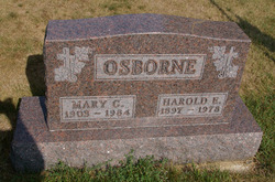
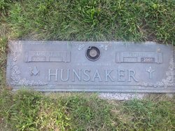
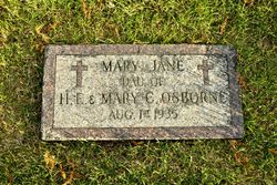
Mary Catherine Hunsaker Osborne
| Birth | : | 20 Oct 1903 Van Wert County, Ohio, USA |
| Death | : | 10 Dec 1984 Delphos, Allen County, Ohio, USA |
| Burial | : | St. Helen's Cemetery and Crematorium, St Helens, Metropolitan Borough of St Helens, England |
| Coordinate | : | 53.4678993, -2.7607000 |
| Description | : | Mary C. Osborne, 81, died at 5:50 a.m. today at Delphos Memorial Home. She was born Oct. 20, 1903, in Van Wert, the daughter of Charles and Sarah (Denlinger) Hunsaker. She married Harold E. Osborne, who died May 13, 1978. Mrs. Osborne was a homemaker. She was a member of St. Rose Catholic Church and its Altar and Rosary Society. Survivors include three daughters, Mrs. Lawrence (Helen) Musgrave, Mrs. William J. (Nancy) Moening and Rita Claybaugh, all of Lima; six grandchildren; two brothers, John lIunsaker and Robert Hunsaker, both of Lima; and a sister, Mrs. John (Dorothy) Phillips of Lima. Funeral... Read More |
frequently asked questions (FAQ):
-
Where is Mary Catherine Hunsaker Osborne's memorial?
Mary Catherine Hunsaker Osborne's memorial is located at: St. Helen's Cemetery and Crematorium, St Helens, Metropolitan Borough of St Helens, England.
-
When did Mary Catherine Hunsaker Osborne death?
Mary Catherine Hunsaker Osborne death on 10 Dec 1984 in Delphos, Allen County, Ohio, USA
-
Where are the coordinates of the Mary Catherine Hunsaker Osborne's memorial?
Latitude: 53.4678993
Longitude: -2.7607000
Family Members:
Parent

Spouse

Siblings
Children

Flowers:


Nearby Cemetories:
1. St. Helen's Cemetery and Crematorium
St Helens, Metropolitan Borough of St Helens, England
Coordinate: 53.4678993, -2.7607000
2. Windleshaw Chantry
St Helens, Metropolitan Borough of St Helens, England
Coordinate: 53.4672417, -2.7550773
3. Christ Church Churchyard
Eccleston, Metropolitan Borough of St Helens, England
Coordinate: 53.4542560, -2.7778900
4. Friends Meeting House, Hardshaw, St Helens
St Helens, Metropolitan Borough of St Helens, England
Coordinate: 53.4518340, -2.7320414
5. GreenAcres Cemetery
Rainford, Metropolitan Borough of St Helens, England
Coordinate: 53.4713530, -2.8064280
6. St Mary Roman Catholic Churchyard
Billinge, Metropolitan Borough of St Helens, England
Coordinate: 53.4909850, -2.7180090
7. All Saints Church
Rainford, Metropolitan Borough of St Helens, England
Coordinate: 53.5000210, -2.7870990
8. St Peter's of Parr Churchyard
Parr, Metropolitan Borough of St Helens, England
Coordinate: 53.4543745, -2.7009772
9. St Mark Churchyard
Haydock, Metropolitan Borough of St Helens, England
Coordinate: 53.4658540, -2.6892980
10. St Nicholas Churchyard
St Helens, Metropolitan Borough of St Helens, England
Coordinate: 53.4284660, -2.7213830
11. St. Anne and Blessed Dominic Churchyard
St Helens, Metropolitan Borough of St Helens, England
Coordinate: 53.4330960, -2.7083700
12. St. Mary the Virgin Churchyard
Prescot, Metropolitan Borough of Knowsley, England
Coordinate: 53.4284600, -2.8067000
13. Prescot Cemetery
Prescot, Metropolitan Borough of Knowsley, England
Coordinate: 53.4266620, -2.8081590
14. St Ann’s Graveyard
Rainhill, Metropolitan Borough of St Helens, England
Coordinate: 53.4157487, -2.7638276
15. St. Mary's Churchyard
Knowsley, Metropolitan Borough of Knowsley, England
Coordinate: 53.4561960, -2.8528580
16. St James' Churchyard
Haydock, Metropolitan Borough of St Helens, England
Coordinate: 53.4679080, -2.6596350
17. St Bartholomew's Churchyard
Rainhill, Metropolitan Borough of St Helens, England
Coordinate: 53.4076231, -2.7513287
18. Knowsley Cemetery
Knowsley, Metropolitan Borough of Knowsley, England
Coordinate: 53.4083240, -2.7847870
19. Holy Trinity Churchyard
Ashton-In-Makerfield, Metropolitan Borough of Wigan, England
Coordinate: 53.4989280, -2.6688000
20. St. Nicholas' Churchyard
Whiston, Metropolitan Borough of Knowsley, England
Coordinate: 53.4069736, -2.8028920
21. St James Roman Catholic Churchyard
Orrell, Metropolitan Borough of Wigan, England
Coordinate: 53.5300000, -2.7140000
22. St. Michael Churchyard
Huyton with Roby, Metropolitan Borough of Knowsley, England
Coordinate: 53.4139560, -2.8396720
23. Salem Churchyard
Orrell, Metropolitan Borough of Wigan, England
Coordinate: 53.5331572, -2.7107046
24. St Michael Churchyard Extension
Huyton with Roby, Metropolitan Borough of Knowsley, England
Coordinate: 53.4143310, -2.8418050