Mary Catherine “Kate” Wilson Patterson
| Birth | : | 12 Jan 1848 |
| Death | : | 4 Sep 1920 |
| Burial | : | Elmwood Cemetery, Beloit, Mitchell County, USA |
| Coordinate | : | 39.4693985, -98.1014023 |
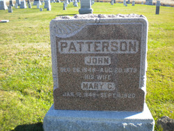
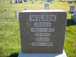
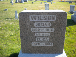
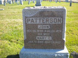
| Description | : | Mary C. Wilson was born January 12th, 1848, in Durborn [sic-this should be Dearborn] county, Indiana and passed from this life at her home in Milton, Iowa, September 4th 1920, being 72 years, 7 months and 22 days old at the time of her death. She was the oldest daughter of Josiah and Eliza Wilson. The family moved to Iowa in 1848, and settled on a farm near Lebanon in Van Buren county. It was here she lived and grew to womanhood. She was married to John Patterson November 7th, 1868. Three children were born to them Emma E. Rowe... Read More |
frequently asked questions (FAQ):
-
Where is Mary Catherine “Kate” Wilson Patterson's memorial?
Mary Catherine “Kate” Wilson Patterson's memorial is located at: Elmwood Cemetery, Beloit, Mitchell County, USA.
-
When did Mary Catherine “Kate” Wilson Patterson death?
Mary Catherine “Kate” Wilson Patterson death on 4 Sep 1920 in
-
Where are the coordinates of the Mary Catherine “Kate” Wilson Patterson's memorial?
Latitude: 39.4693985
Longitude: -98.1014023
Family Members:
Parent
Spouse
Siblings
Children
Flowers:
Nearby Cemetories:
1. Elmwood Cemetery
Beloit, Mitchell County, USA
Coordinate: 39.4693985, -98.1014023
2. Saint Johns Cemetery
Beloit, Mitchell County, USA
Coordinate: 39.4667015, -98.1018982
3. Beloit Industrial School Cemetery
Beloit, Mitchell County, USA
Coordinate: 39.4755000, -98.1105810
4. Pleasant Valley Cemetery
Beloit, Mitchell County, USA
Coordinate: 39.4555900, -98.1722200
5. Smith Cemetery
Asherville, Mitchell County, USA
Coordinate: 39.4516690, -98.0098850
6. McBride Cemetery
Beloit, Mitchell County, USA
Coordinate: 39.4808006, -97.9907990
7. Bell-Bogardus Cemetery
Asherville, Mitchell County, USA
Coordinate: 39.4242410, -97.9919970
8. Glendale Cemetery
Solomon Rapids, Mitchell County, USA
Coordinate: 39.5537300, -98.1813000
9. West Asher Cemetery
Scottsville, Mitchell County, USA
Coordinate: 39.4815000, -97.9661600
10. Asherville Cemetery
Asherville, Mitchell County, USA
Coordinate: 39.4205000, -97.9672900
11. Shiloh Cemetery
Beloit, Mitchell County, USA
Coordinate: 39.3574982, -98.0594025
12. New Hope Cemetery
Beloit, Mitchell County, USA
Coordinate: 39.3502998, -98.0875015
13. Honey Creek Cemetery
Solomon Rapids, Mitchell County, USA
Coordinate: 39.4328003, -98.2517014
14. Star Cemetery
Jewell, Jewell County, USA
Coordinate: 39.5882500, -98.1379400
15. Hopewell Cemetery
Beloit, Mitchell County, USA
Coordinate: 39.3800011, -98.2097015
16. Pleasant Prairie Cemetery
Randall, Jewell County, USA
Coordinate: 39.5896988, -98.0627975
17. Browns Creek Cemetery
Solomon Rapids, Mitchell County, USA
Coordinate: 39.5393982, -98.2463989
18. Atkins Union Cemetery
Jewell, Jewell County, USA
Coordinate: 39.5956000, -98.1733000
19. Pleasant View Cemetery
Beloit, Mitchell County, USA
Coordinate: 39.3360939, -98.1519852
20. Scottsville Cemetery
Scottsville, Mitchell County, USA
Coordinate: 39.5468102, -97.9474945
21. Glenwood Cemetery
Glen Elder, Mitchell County, USA
Coordinate: 39.5052986, -98.2818985
22. West Hope Cemetery
Jewell County, USA
Coordinate: 39.5896988, -97.9871979
23. Summit Cemetery #3
Macyville, Cloud County, USA
Coordinate: 39.5258330, -97.9194440
24. Fairview Cemetery South
Glen Elder, Mitchell County, USA
Coordinate: 39.4667015, -98.3063965

