
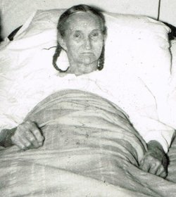

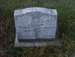

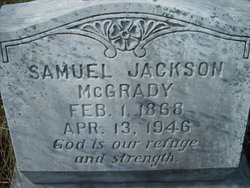
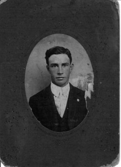
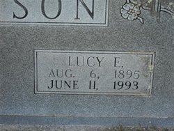
Mary Elizabeth Gardner McGrady
| Birth | : | 26 Nov 1869 Hillsville, Carroll County, Virginia, USA |
| Death | : | 20 Aug 1960 Barren Springs, Wythe County, Virginia, USA |
| Burial | : | Mound Hill Cemetery, Eaton, Preble County, USA |
| Coordinate | : | 39.7411003, -84.6461029 |
frequently asked questions (FAQ):
-
Where is Mary Elizabeth Gardner McGrady's memorial?
Mary Elizabeth Gardner McGrady's memorial is located at: Mound Hill Cemetery, Eaton, Preble County, USA.
-
When did Mary Elizabeth Gardner McGrady death?
Mary Elizabeth Gardner McGrady death on 20 Aug 1960 in Barren Springs, Wythe County, Virginia, USA
-
Where are the coordinates of the Mary Elizabeth Gardner McGrady's memorial?
Latitude: 39.7411003
Longitude: -84.6461029
Family Members:
Parent

Spouse
Siblings


Children

Flowers:


Nearby Cemetories:
1. Mound Hill Cemetery
Eaton, Preble County, USA
Coordinate: 39.7411003, -84.6461029
2. Fort Saint Clair Cemetery
Preble County, USA
Coordinate: 39.7374992, -84.6549988
3. Preble County Home Cemetery
Eaton, Preble County, USA
Coordinate: 39.7618970, -84.6481170
4. Fisher Cemetery
Eaton, Preble County, USA
Coordinate: 39.7289400, -84.6185600
5. Campbell Cemetery
Eaton, Preble County, USA
Coordinate: 39.7172740, -84.6224530
6. Antioch Cemetery
Eaton, Preble County, USA
Coordinate: 39.7000008, -84.6318970
7. Crumbaker Cemetery
Eaton, Preble County, USA
Coordinate: 39.7696730, -84.6904060
8. Bell Cemetery
Eaton, Preble County, USA
Coordinate: 39.7582970, -84.5886040
9. Friendship Cemetery
Sugar Valley, Preble County, USA
Coordinate: 39.7043991, -84.6939011
10. Spacht Cemetery
Preble County, USA
Coordinate: 39.7875500, -84.6774500
11. Fisher Cemetery
West Alexandria, Preble County, USA
Coordinate: 39.7267200, -84.5760600
12. Frame Cemetery
Eaton, Preble County, USA
Coordinate: 39.7641560, -84.7122290
13. Preble Memory Gardens
West Alexandria, Preble County, USA
Coordinate: 39.7451782, -84.5727539
14. Sample-Stover Cemetery
Sampleville, Preble County, USA
Coordinate: 39.7417870, -84.5708070
15. Bonebrake Cemetery
New Hope, Preble County, USA
Coordinate: 39.7867200, -84.6999600
16. Zion Cemetery
Eaton, Preble County, USA
Coordinate: 39.8104858, -84.6306305
17. Camp Run Cemetery
Wheatville, Preble County, USA
Coordinate: 39.6758347, -84.6083298
18. Harris Cemetery
West Florence, Preble County, USA
Coordinate: 39.7262500, -84.7370300
19. Marshall Graveyard
Sugar Valley, Preble County, USA
Coordinate: 39.6883580, -84.7092460
20. Poyner Cemetery
Preble County, USA
Coordinate: 39.6739006, -84.6853027
21. Conger Graveyard
Sugar Valley, Preble County, USA
Coordinate: 39.6882250, -84.7157860
22. Felton Cemetery
Camden, Preble County, USA
Coordinate: 39.6715202, -84.6885376
23. Brower Cemetery
West Alexandria, Preble County, USA
Coordinate: 39.7287750, -84.5473480
24. Sugar Valley Cemetery
Sugar Valley, Preble County, USA
Coordinate: 39.6850014, -84.7155991