
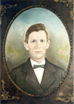

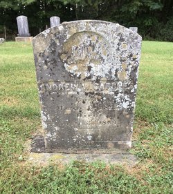
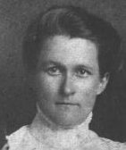
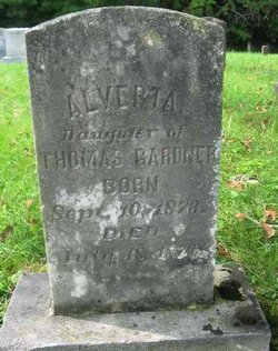
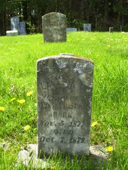
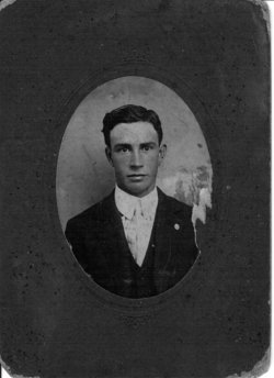
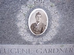
Thomas C Gardner
| Birth | : | 15 May 1847 Carroll County, Virginia, USA |
| Death | : | 11 Nov 1932 Laurel Fork, Carroll County, Virginia, USA |
| Burial | : | Droylsden Cemetery, Droylsden, Metropolitan Borough of Tameside, England |
| Coordinate | : | 53.4849400, -2.1529696 |
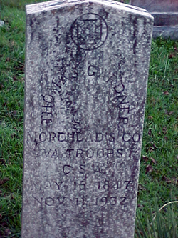
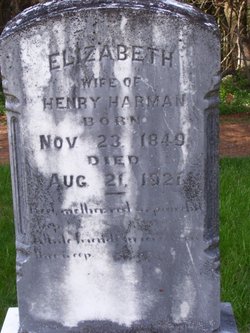
| Inscription | : | The stone reads: THOMAS GARDNER MOREHEAD'S CO VA TROOPS C.S.A. MAY 15 1847 NOV 11 1932 |
frequently asked questions (FAQ):
-
Where is Thomas C Gardner's memorial?
Thomas C Gardner's memorial is located at: Droylsden Cemetery, Droylsden, Metropolitan Borough of Tameside, England.
-
When did Thomas C Gardner death?
Thomas C Gardner death on 11 Nov 1932 in Laurel Fork, Carroll County, Virginia, USA
-
Where are the coordinates of the Thomas C Gardner's memorial?
Latitude: 53.4849400
Longitude: -2.1529696
Family Members:
Parent
Spouse
Siblings
Children

Flowers:


Nearby Cemetories:
1. Droylsden Cemetery
Droylsden, Metropolitan Borough of Tameside, England
Coordinate: 53.4849400, -2.1529696
2. St Cross Churchyard
Clayton, Metropolitan Borough of Manchester, England
Coordinate: 53.4832190, -2.1823530
3. Failsworth Cemetery
Failsworth, Metropolitan Borough of Oldham, England
Coordinate: 53.5048760, -2.1537550
4. Failsworth Jewish Cemetery
Failsworth, Metropolitan Borough of Oldham, England
Coordinate: 53.5050270, -2.1534220
5. All Saints Churchyard
Newton Heath, Metropolitan Borough of Manchester, England
Coordinate: 53.5002260, -2.1777970
6. Saint Stephens Churchyard
Audenshaw, Metropolitan Borough of Tameside, England
Coordinate: 53.4753000, -2.1151700
7. St. Peter's Churchyard
Ashton-Under-Lyne, Metropolitan Borough of Tameside, England
Coordinate: 53.4839340, -2.1054690
8. Philips Park Cemetery
Miles Platting, Metropolitan Borough of Manchester, England
Coordinate: 53.4898020, -2.2007400
9. Gorton Cemetery
Manchester, Metropolitan Borough of Manchester, England
Coordinate: 53.4567080, -2.1632580
10. Audenshaw Cemetery
Audenshaw, Metropolitan Borough of Tameside, England
Coordinate: 53.4653300, -2.1101560
11. Oldham Crematorium
Oldham, Metropolitan Borough of Oldham, England
Coordinate: 53.5156810, -2.1332800
12. Christ Church Churchyard
Denton, Metropolitan Borough of Tameside, England
Coordinate: 53.4560270, -2.1218270
13. Hollinwood Cemetery
Oldham, Metropolitan Borough of Oldham, England
Coordinate: 53.5178170, -2.1329170
14. Saint Mary's Churchyard
Moston, Metropolitan Borough of Manchester, England
Coordinate: 53.5181740, -2.1763410
15. St. Joseph's Roman Catholic Churchyard
Moston, Metropolitan Borough of Manchester, England
Coordinate: 53.5149270, -2.1877070
16. Dukinfield Cemetery and Crematorium
Dukinfield, Metropolitan Borough of Tameside, England
Coordinate: 53.4800300, -2.0857150
17. Former Saint Johns Churchyard
Longsight, Metropolitan Borough of Manchester, England
Coordinate: 53.4570760, -2.2025800
18. St Lawrence Church
Denton, Metropolitan Borough of Tameside, England
Coordinate: 53.4520000, -2.1109000
19. All Saints Churchyard
Chorlton-on-Medlock, Metropolitan Borough of Manchester, England
Coordinate: 53.4666670, -2.2166670
20. Manchester General Cemetery
Manchester, Metropolitan Borough of Manchester, England
Coordinate: 53.5062710, -2.2179570
21. St Thomas Churchyard
Ardwick, Metropolitan Borough of Manchester, England
Coordinate: 53.4720000, -2.2248900
22. Christchurch Harpurhey Churchyard
Harpurhey, Metropolitan Borough of Manchester, England
Coordinate: 53.5115100, -2.2134800
23. St. John the Evangelist Churchyard
Hurst, Metropolitan Borough of Tameside, England
Coordinate: 53.5001310, -2.0812490
24. St Elisabeth Church
Reddish, Metropolitan Borough of Stockport, England
Coordinate: 53.4379400, -2.1633950