
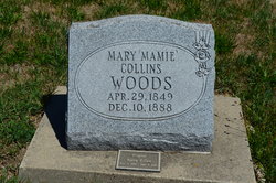
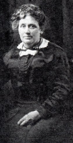
Mary Elizabeth “Mamie” Collins Woods
| Birth | : | 29 Apr 1849 Iowa, USA |
| Death | : | 10 Dec 1888 Iowa, USA |
| Burial | : | Dayton Cemetery, Dayton, Webster County, USA |
| Coordinate | : | 42.2675000, -94.0755000 |
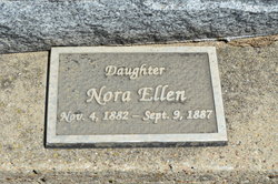
| Description | : | After her sister Adelia Collins died, Mamie Collins went to help her brother-in-law with her nieces and nephews. Mamie married Robert Turner Woods October 15, 1871 in Muscatine, Iowa. She and Robert had 8 children: Lydia Margaret 1872-1944, Volentine 1875-1935, Robert Elsworth 1877-1959, John 1878-1897, Olive G. 1881-1959, Nora Ellen 1882-1887, Eva Mae 1885-1983 and James Edward 1887-1953. Mary died on December 10, 1888 from the burns she suffered after her clothing and hair caught fire earlier that day. It was reported in the Dayton Review newspaper Dec. 13, 1888. She was buried on their farm and later two of... Read More |
frequently asked questions (FAQ):
-
Where is Mary Elizabeth “Mamie” Collins Woods's memorial?
Mary Elizabeth “Mamie” Collins Woods's memorial is located at: Dayton Cemetery, Dayton, Webster County, USA.
-
When did Mary Elizabeth “Mamie” Collins Woods death?
Mary Elizabeth “Mamie” Collins Woods death on 10 Dec 1888 in Iowa, USA
-
Where are the coordinates of the Mary Elizabeth “Mamie” Collins Woods's memorial?
Latitude: 42.2675000
Longitude: -94.0755000
Family Members:
Parent
Spouse
Siblings

Children
Flowers:


Nearby Cemetories:
1. Dayton Cemetery
Dayton, Webster County, USA
Coordinate: 42.2675000, -94.0755000
2. Christ the King Catholic Cemetery
Dayton, Webster County, USA
Coordinate: 42.2601929, -94.0727539
3. Bass Cemetery
Dayton, Webster County, USA
Coordinate: 42.2966995, -94.0149994
4. Swedish Lutheran Church Cemetery
Dayton, Webster County, USA
Coordinate: 42.2175000, -94.1065000
5. Oak Grove Cemetery
Lehigh, Webster County, USA
Coordinate: 42.3438988, -94.0475006
6. Hardin Township Cemetery
Hardin Township, Webster County, USA
Coordinate: 42.2411003, -93.9708023
7. Linn Cemetery
Pilot Mound, Boone County, USA
Coordinate: 42.2045330, -93.9970230
8. Lawn Cemetery
Boone County, USA
Coordinate: 42.1771011, -94.0867996
9. West Lawn Cemetery
Lehigh, Webster County, USA
Coordinate: 42.3616982, -94.0678024
10. McGuire Bend Cemetery
Dayton, Webster County, USA
Coordinate: 42.3410000, -93.9880000
11. Runyan Cemetery
Pilot Mound, Boone County, USA
Coordinate: 42.1749992, -94.0015030
12. Pilot Mound Cemetery
Pilot Mound, Boone County, USA
Coordinate: 42.1636200, -94.0282600
13. Vegors Cemetery
Webster County, USA
Coordinate: 42.3177986, -93.9421997
14. Lost Grove Cemetery
Harcourt, Webster County, USA
Coordinate: 42.2583008, -94.2331009
15. Hooks Point Cemetery
Hamilton County, USA
Coordinate: 42.2944530, -93.9199090
16. Oakwood Cemetery
Stratford, Hamilton County, USA
Coordinate: 42.2942009, -93.9182968
17. Hartman Cemetery
Lehigh, Webster County, USA
Coordinate: 42.3666397, -93.9835627
18. White Cemetery
Boone County, USA
Coordinate: 42.1777992, -93.9636002
19. Border Plains Cemetery
Border Plains, Webster County, USA
Coordinate: 42.3917000, -94.0448000
20. Ober and Scott Cemetery
Duncombe, Webster County, USA
Coordinate: 42.3841390, -93.9982856
21. Union Cemetery
Boxholm, Boone County, USA
Coordinate: 42.1369019, -94.0852966
22. Renner Cemetery
Boone County, USA
Coordinate: 42.1380420, -94.1256570
23. Otho Cemetery
Otho, Webster County, USA
Coordinate: 42.4025002, -94.1153030
24. Schlicht Cemetery
Fraser, Boone County, USA
Coordinate: 42.1444200, -93.9780100