
| Birth | : | 29 Jul 1902 Union County, Iowa, USA |
| Death | : | 27 Oct 1970 Rifle, Garfield County, Colorado, USA |
| Burial | : | Rose Hill Cemetery, Rifle, Garfield County, USA |
| Coordinate | : | 39.5381012, -107.7742004 |
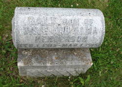
| Description | : | Head stone is incorrect as far as anyone knows she passed away the 27th Born in Pleasant Creek Township, Mary D. Arnett Funeral services for Mrs. Charles H. Arnett will be held Friday Oct 30 at 3 p.m. at the first Christian Church with pastor George Flemming and Rev. Otto B. Duckworth Officiating. Burial will be in Rose Hill Cemetery. The Sowder funeral home is in charge of arrangements. Mrs Arnett passed away early Tuesday evening at the Clagett Memorial Hospital |
frequently asked questions (FAQ):
-
Where is Mary Ethel “Darlene” Henderson Arnett's memorial?
Mary Ethel “Darlene” Henderson Arnett's memorial is located at: Rose Hill Cemetery, Rifle, Garfield County, USA.
-
When did Mary Ethel “Darlene” Henderson Arnett death?
Mary Ethel “Darlene” Henderson Arnett death on 27 Oct 1970 in Rifle, Garfield County, Colorado, USA
-
Where are the coordinates of the Mary Ethel “Darlene” Henderson Arnett's memorial?
Latitude: 39.5381012
Longitude: -107.7742004
Family Members:
Parent

Spouse
Siblings
Children
Flowers:


Nearby Cemetories:
1. Rose Hill Cemetery
Rifle, Garfield County, USA
Coordinate: 39.5381012, -107.7742004
2. Skyline Cemetery
Silt, Garfield County, USA
Coordinate: 39.5520060, -107.6575300
3. Rulison Cemetery
Rulison, Garfield County, USA
Coordinate: 39.4768000, -107.9357000
4. Union Divide Creek Cemetery
Silt, Garfield County, USA
Coordinate: 39.4508018, -107.6200027
5. Highland Cemetery
New Castle, Garfield County, USA
Coordinate: 39.5875015, -107.5192032
6. Battlement Cemetery
Parachute, Garfield County, USA
Coordinate: 39.4380989, -108.0291977
7. Russey-Hurlburt Cemetery
Parachute, Garfield County, USA
Coordinate: 39.4522018, -108.0575027
8. Blackman Ranch Cemetery
Collbran, Mesa County, USA
Coordinate: 39.2647420, -107.8554350
9. Clover Cemetery
Collbran, Mesa County, USA
Coordinate: 39.2550011, -107.9227982
10. Cedar Crest Cemetery
Collbran, Mesa County, USA
Coordinate: 39.2369003, -107.9589005
11. Farnum Holt Columbarium
Glenwood Springs, Garfield County, USA
Coordinate: 39.5469640, -107.3299900
12. Pioneer Cemetery
Glenwood Springs, Garfield County, USA
Coordinate: 39.5392000, -107.3192000
13. Rosebud Cemetery
Glenwood Springs, Garfield County, USA
Coordinate: 39.5168991, -107.3189011
14. Eagalite Cemetery
Plateau City, Mesa County, USA
Coordinate: 39.2228012, -107.9894028
15. DeBeque Cemetery
Mesa County, USA
Coordinate: 39.3374060, -108.2138900
16. Marion Cemetery
Garfield County, USA
Coordinate: 39.3689003, -107.3047028
17. Molina Cemetery
Molina, Mesa County, USA
Coordinate: 39.1886000, -108.0629000
18. Evergreen Cemetery
Carbondale, Garfield County, USA
Coordinate: 39.4077988, -107.2155991
19. Fisher Cemetery
Carbondale, Garfield County, USA
Coordinate: 39.4791985, -107.1911011
20. Mesa Cemetery
Mesa, Mesa County, USA
Coordinate: 39.1685982, -108.1188965
21. Hillcrest Cemetery
Carbondale, Garfield County, USA
Coordinate: 39.3922005, -107.1936035
22. Highland Cemetery
Meeker, Rio Blanco County, USA
Coordinate: 40.0311012, -107.9111023
23. Camp on White River Cemetery
Meeker, Rio Blanco County, USA
Coordinate: 40.0380100, -107.9131000
24. Black Sulphur Cemetery
Meeker, Rio Blanco County, USA
Coordinate: 39.8600800, -108.3109500