
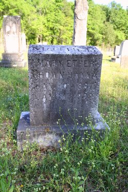
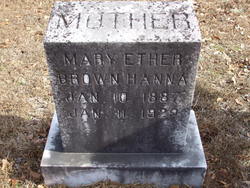
| Birth | : | 10 Jan 1887 |
| Death | : | 11 Jan 1929 |
| Burial | : | East View Cemetery, Salem, Salem County, USA |
| Coordinate | : | 39.5627480, -75.4561081 |
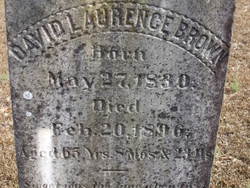
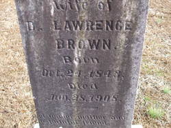
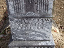
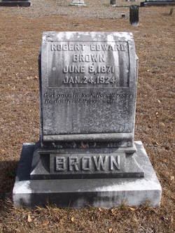
| Inscription | : | Wife of Arthur C. Hanna / Buried at Brown Cemetery, Lake City, SC |
| Description | : | Wife of Arthur C. Hanna. |
frequently asked questions (FAQ):
-
Where is Mary Ether Brown Hanna's memorial?
Mary Ether Brown Hanna's memorial is located at: East View Cemetery, Salem, Salem County, USA.
-
When did Mary Ether Brown Hanna death?
Mary Ether Brown Hanna death on 11 Jan 1929 in
-
Where are the coordinates of the Mary Ether Brown Hanna's memorial?
Latitude: 39.5627480
Longitude: -75.4561081
Family Members:
Parent
Spouse
Siblings

Flowers:


Nearby Cemetories:
1. East View Cemetery
Salem, Salem County, USA
Coordinate: 39.5627480, -75.4561081
2. Baptist Cemetery
Salem, Salem County, USA
Coordinate: 39.5621681, -75.4611053
3. Mount Hope United Methodist Church Cemetery
Salem, Salem County, USA
Coordinate: 39.5660667, -75.4606781
4. Saint Mary's Roman Catholic Cemetery
Salem, Salem County, USA
Coordinate: 39.5637856, -75.4684753
5. First United Methodist Church Cemetery
Salem, Salem County, USA
Coordinate: 39.5695496, -75.4670868
6. Mount Pisgah AME Cemetery
Salem County, USA
Coordinate: 39.5549700, -75.4663900
7. Evergreen Cemetery
Salem, Salem County, USA
Coordinate: 39.5540000, -75.4652000
8. First Presbyterian Cemetery
Salem, Salem County, USA
Coordinate: 39.5736351, -75.4648819
9. Saint John's Episcopal Churchyard
Salem, Salem County, USA
Coordinate: 39.5744705, -75.4655151
10. Salem Friends Burial Ground
Salem, Salem County, USA
Coordinate: 39.5732307, -75.4705963
11. Mill Hollow Cemetery
Quinton, Salem County, USA
Coordinate: 39.5563120, -75.4305770
12. Alloway Creek Old Quaker Burial Ground
Lower Alloways Creek Township, Salem County, USA
Coordinate: 39.5202900, -75.4597000
13. Hancocks Bridge United Methodist Church Cemetery
Harmersville, Salem County, USA
Coordinate: 39.5023537, -75.4411850
14. Cedar Hill Friends Cemetery
Harmersville, Salem County, USA
Coordinate: 39.5014720, -75.4387800
15. Alloway Baptist Church Cemetery
Alloway, Salem County, USA
Coordinate: 39.5606308, -75.3655090
16. Battle of Quintons Bridge Graveyard
Quinton, Salem County, USA
Coordinate: 39.5130650, -75.3884040
17. Dunham Family Cemetery
Pennsville, Salem County, USA
Coordinate: 39.6138890, -75.5268330
18. Alloway United Methodist Church Cemetery
Alloway, Salem County, USA
Coordinate: 39.5623207, -75.3586273
19. Little Bethel A.M.E Church Cemetery
Marshalltown, Salem County, USA
Coordinate: 39.6381190, -75.4537830
20. Berrys Chapel Cemetery
Quinton, Salem County, USA
Coordinate: 39.5137900, -75.3779510
21. Old Alloway Cemetery
Alloway, Salem County, USA
Coordinate: 39.5619545, -75.3549957
22. Mount Zion AUMP Church Cemetery
Marshalltown, Salem County, USA
Coordinate: 39.6410060, -75.4554070
23. Lower Penns Neck Methodist Episcopal Cemetery
Pennsville, Salem County, USA
Coordinate: 39.6383120, -75.5164490
24. Canton Baptist Church Cemetery
Canton, Salem County, USA
Coordinate: 39.4799385, -75.4120789