
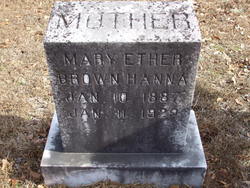
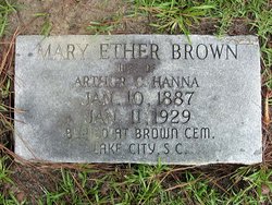
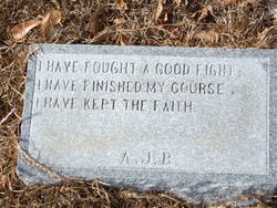
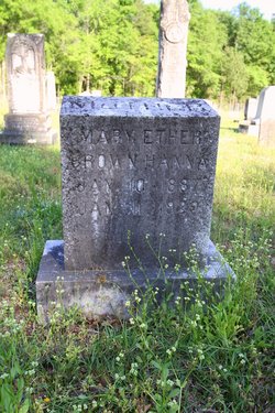
Mary Ether Brown Hanna
| Birth | : | 10 Jan 1887 |
| Death | : | 11 Jan 1929 |
| Burial | : | Liberty Cemetery, Upland, Dickinson County, USA |
| Coordinate | : | 39.0896988, -97.0278015 |
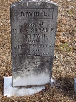
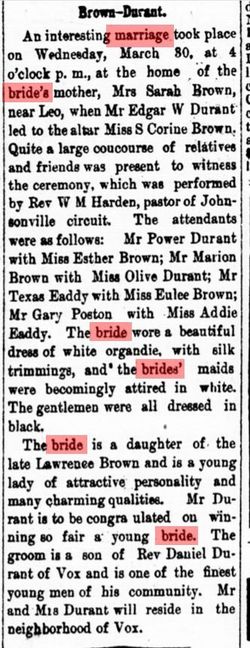
| Description | : | Wife of Arthur Hanna, burried at Westview Cemetery, Moncks Corner South Carolina Parents David Lawrence Brown Sr. Sarah Elizabeth Graham |
frequently asked questions (FAQ):
-
Where is Mary Ether Brown Hanna's memorial?
Mary Ether Brown Hanna's memorial is located at: Liberty Cemetery, Upland, Dickinson County, USA.
-
When did Mary Ether Brown Hanna death?
Mary Ether Brown Hanna death on 11 Jan 1929 in
-
Where are the coordinates of the Mary Ether Brown Hanna's memorial?
Latitude: 39.0896988
Longitude: -97.0278015
Family Members:
Parent
Spouse
Siblings

Children
Flowers:


Nearby Cemetories:
1. Liberty Cemetery
Upland, Dickinson County, USA
Coordinate: 39.0896988, -97.0278015
2. Alida Zion Evangelical Cemetery
Upland, Dickinson County, USA
Coordinate: 39.0750008, -96.9721985
3. Jones Cemetery
Dickinson County, USA
Coordinate: 39.0703011, -97.0860977
4. Alida Cemetery
Geary County, USA
Coordinate: 39.1030998, -96.9618988
5. Saint Johns Cemetery
Geary County, USA
Coordinate: 39.0741997, -96.9610977
6. Good Hope Cemetery
Chapman, Dickinson County, USA
Coordinate: 39.0388985, -96.9991989
7. Sutphen Mill Cemetery
Chapman, Dickinson County, USA
Coordinate: 39.0330190, -97.0368770
8. Greenridge Cemetery
Dickinson County, USA
Coordinate: 39.1199989, -97.1433029
9. Madura Cemetery
Wakefield, Clay County, USA
Coordinate: 39.1842003, -97.0117035
10. Bethel Cemetery
Moonlight, Dickinson County, USA
Coordinate: 39.0022011, -97.1110535
11. Saint Patricks Cemetery
Chapman, Dickinson County, USA
Coordinate: 38.9803330, -97.0062850
12. Buckeye Cemetery
Buckeye, Dickinson County, USA
Coordinate: 39.0463070, -97.1665840
13. Indian Hill Cemetery
Chapman, Dickinson County, USA
Coordinate: 38.9714012, -97.0327988
14. Henry Cemetery
Buckeye, Dickinson County, USA
Coordinate: 39.0828018, -97.1857986
15. Branscom Cemetery
Milford, Geary County, USA
Coordinate: 39.1627998, -96.8942032
16. Barry Cemetery
Milford, Geary County, USA
Coordinate: 39.1889000, -96.9218979
17. Highland Cemetery
Wakefield, Clay County, USA
Coordinate: 39.2190247, -97.0133667
18. Milford Cemetery
Milford, Geary County, USA
Coordinate: 39.1828003, -96.9047012
19. Timber Creek Cemetery
Wakefield, Clay County, USA
Coordinate: 39.2182999, -96.9805984
20. Saint John's Episcopal Cemetery
Clay County, USA
Coordinate: 39.2193985, -97.0744019
21. Mizpah Cemetery
Clay County, USA
Coordinate: 39.2057800, -97.1238500
22. Union Cemetery
Buckeye, Dickinson County, USA
Coordinate: 39.0243988, -97.1856003
23. Athelstane Cemetery
Athelstane Township, Clay County, USA
Coordinate: 39.1768990, -97.1753006
24. Geary County Poor Farm Cemetery
Junction City, Geary County, USA
Coordinate: 39.0064500, -96.8727100