
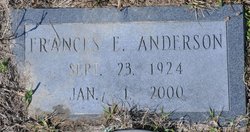

Mary Frances “Frank” Edmondson Anderson
| Birth | : | 23 Sep 1924 |
| Death | : | 1 Jan 2000 |
| Burial | : | St. Mary's Churchyard, Bridgwater, Sedgemoor District, England |
| Coordinate | : | 51.1277430, -3.0050330 |
frequently asked questions (FAQ):
-
Where is Mary Frances “Frank” Edmondson Anderson's memorial?
Mary Frances “Frank” Edmondson Anderson's memorial is located at: St. Mary's Churchyard, Bridgwater, Sedgemoor District, England.
-
When did Mary Frances “Frank” Edmondson Anderson death?
Mary Frances “Frank” Edmondson Anderson death on 1 Jan 2000 in
-
Where are the coordinates of the Mary Frances “Frank” Edmondson Anderson's memorial?
Latitude: 51.1277430
Longitude: -3.0050330
Family Members:
Parent
Spouse
Siblings
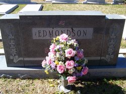

Flowers:


Nearby Cemetories:
1. St. Mary's Churchyard
Bridgwater, Sedgemoor District, England
Coordinate: 51.1277430, -3.0050330
2. Bridgwater Baptist Church
Bridgwater, Sedgemoor District, England
Coordinate: 51.1272613, -3.0046282
3. Gray Friar's
Bridgwater, Sedgemoor District, England
Coordinate: 51.1264260, -3.0065160
4. Quaker Burial Ground
Bridgwater, Sedgemoor District, England
Coordinate: 51.1261740, -3.0078020
5. Former Holy Trinity Churchyard
Bridgwater, Sedgemoor District, England
Coordinate: 51.1261850, -3.0021850
6. Wembdon Road Cemetery
Bridgwater, Sedgemoor District, England
Coordinate: 51.1280877, -3.0138897
7. St John The Baptist Churchyard
Bridgwater, Sedgemoor District, England
Coordinate: 51.1311160, -2.9969910
8. St George Churchyard
Wembdon, Sedgemoor District, England
Coordinate: 51.1364420, -3.0171170
9. St. John Bristol Road Cemetery
Bridgwater, Sedgemoor District, England
Coordinate: 51.1391470, -2.9901660
10. Quantock Road Cemetery
Bridgwater, Sedgemoor District, England
Coordinate: 51.1284270, -3.0285630
11. Holy Trinity Churchyard
Chilton Trinity, Sedgemoor District, England
Coordinate: 51.1474390, -3.0072360
12. St Hugh's Church
Durleigh, Sedgemoor District, England
Coordinate: 51.1198090, -3.0375260
13. Heathfield Cemetery
North Petherton, Sedgemoor District, England
Coordinate: 51.0957200, -3.0081100
14. St. Mary Parish Churchyard
North Petherton, Sedgemoor District, England
Coordinate: 51.0920790, -3.0149060
15. Church of the Blessed Virgin Mary Churchyard
Chedzoy, Sedgemoor District, England
Coordinate: 51.1344600, -2.9429400
16. Blessed Virgin Mary Churchyard
Cannington, Sedgemoor District, England
Coordinate: 51.1500970, -3.0622850
17. St Edward King and Martyr Churchyard
Goathurst, Sedgemoor District, England
Coordinate: 51.1034930, -3.0633930
18. Saint Michael & All Angels Churchyard
Bawdrip, Sedgemoor District, England
Coordinate: 51.1517260, -2.9429330
19. Cannington Cemetery
Cannington, Sedgemoor District, England
Coordinate: 51.1500620, -3.0697070
20. Saint Michael and All Angels Churchyard
Puriton, Sedgemoor District, England
Coordinate: 51.1706000, -2.9735000
21. Westonzoyland Cemetery New
Westonzoyland, Sedgemoor District, England
Coordinate: 51.1096271, -2.9349336
22. St. John The Baptist Churchyard
Pawlett, Sedgemoor District, England
Coordinate: 51.1789100, -3.0012650
23. The Old Chapel
Westonzoyland, Sedgemoor District, England
Coordinate: 51.1077425, -2.9285237
24. St. Mary's Churchyard
Westonzoyland, Sedgemoor District, England
Coordinate: 51.1087000, -2.9273800