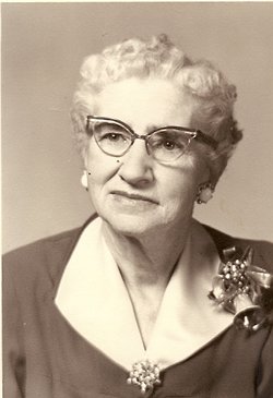
Mary Irene Smith Griffin
| Birth | : | 18 Feb 1877 San Luis Obispo, San Luis Obispo County, California, USA |
| Death | : | 13 Sep 1964 Willows, Glenn County, California, USA |
| Burial | : | Fairview Cemetery, Greenleaf, Brown County, USA |
| Coordinate | : | 44.3130989, -88.0785980 |
| Plot | : | Catholic |
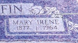
| Inscription | : | GRIFFIN EARL DAVID 1881 - 1953 MARY IRENE 1877 - 1964 |
| Description | : | Mary "Irene" Smith was born 18 Feb 1877 at the Mission San Luis Obispo, San Luis Obispo, CA. Her father, Hugh E. Smith, travelled there on business and her mother, Georgia Anna (Spriggs) Smith, had accompanied him. And oops.. here comes baby Irene. They went to the nuns at the Mission for help and she was born there. Irene married Earl Griffin, her 1st cousin, on 9 Feb 1899. They never had any children of their own, but did adopt a girl and a boy. |
frequently asked questions (FAQ):
-
Where is Mary Irene Smith Griffin's memorial?
Mary Irene Smith Griffin's memorial is located at: Fairview Cemetery, Greenleaf, Brown County, USA.
-
When did Mary Irene Smith Griffin death?
Mary Irene Smith Griffin death on 13 Sep 1964 in Willows, Glenn County, California, USA
-
Where are the coordinates of the Mary Irene Smith Griffin's memorial?
Latitude: 44.3130989
Longitude: -88.0785980
Family Members:
Parent
Spouse
Siblings
Children
Flowers:
Nearby Cemetories:
1. Fairview Cemetery
Greenleaf, Brown County, USA
Coordinate: 44.3130989, -88.0785980
2. Saint Paul Lutheran Cemetery
Greenleaf, Brown County, USA
Coordinate: 44.3132019, -88.0784988
3. Saint Marys Parish Cemetery
Greenleaf, Brown County, USA
Coordinate: 44.3124008, -88.0549011
4. Saint Johns Catholic Cemetery
Morrison, Brown County, USA
Coordinate: 44.2985992, -88.0139008
5. Saint Patricks Catholic Cemetery
Askeaton, Brown County, USA
Coordinate: 44.2637800, -88.0909400
6. Saint John Evangelical Lutheran Cemetery
Wrightstown, Brown County, USA
Coordinate: 44.3139000, -88.1508026
7. Riverside Cemetery
Wrightstown, Brown County, USA
Coordinate: 44.3231010, -88.1663971
8. Morrison Zion Evangelical Lutheran Cemetery
Morrison, Brown County, USA
Coordinate: 44.2890625, -87.9796677
9. Saint Paul Catholic Cemetery
Wrightstown, Brown County, USA
Coordinate: 44.3213997, -88.1877975
10. South Lawrence Cemetery
De Pere, Brown County, USA
Coordinate: 44.3664017, -88.1766968
11. Bluff Cemetery
Brillion, Calumet County, USA
Coordinate: 44.2252998, -88.0643997
12. Saint Michaels Cemetery
De Pere, Brown County, USA
Coordinate: 44.3968000, -88.1197000
13. Kasson-Evergreen Cemetery
Maple Grove, Manitowoc County, USA
Coordinate: 44.2324921, -88.0237094
14. Old Morrison Zion Evangelical Lutheran Cemetery
Wayside, Brown County, USA
Coordinate: 44.2702904, -87.9649353
15. Saint Patrick Catholic Cemetery
Kaukauna, Outagamie County, USA
Coordinate: 44.3358600, -88.2037000
16. Emanuels Cemetery
Morrison, Brown County, USA
Coordinate: 44.2991982, -87.9503021
17. Emmanuel Evangelical Cemetery
Maple Grove, Manitowoc County, USA
Coordinate: 44.2256012, -88.0294037
18. Saint Francis Cemetery
Hollandtown, Brown County, USA
Coordinate: 44.2494400, -88.1778400
19. Zion Lutheran Cemetery
Glenmore, Brown County, USA
Coordinate: 44.3618140, -87.9599760
20. Immanuel Evangelical Lutheran Church Cemetery
Shirley, Brown County, USA
Coordinate: 44.3575070, -87.9526220
21. Forest Home Cemetery
Forest Junction, Calumet County, USA
Coordinate: 44.2275009, -88.1541977
22. Holy Trinity Cemetery
Maple Grove, Manitowoc County, USA
Coordinate: 44.2111015, -88.0346985
23. Bristol Cemetery
De Pere, Brown County, USA
Coordinate: 44.4149430, -88.0215805
24. Saint Marys Cemetery
Glenmore, Brown County, USA
Coordinate: 44.3725000, -87.9475700

