
Mary J. Wood Lee
| Birth | : | 1863 |
| Death | : | 14 Dec 1893 |
| Burial | : | Arthur Cemetery, Arthur, Douglas County, USA |
| Coordinate | : | 39.7151909, -88.4610901 |
| Plot | : | 572 |
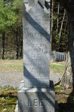
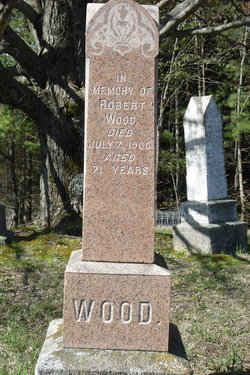
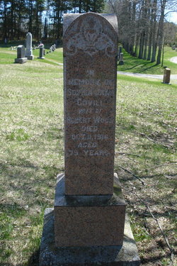
| Description | : | Mary was the daughter of Robert Wood & Sophia Jane Covill. She was married to Robert lee on Nov.5,1890. Mary died 3 years later. Robert got married again on Dec.24,1898 to Annette Elizabeth Wilson, daughter of Andrew Wilson & Charlotte Playfair. Robert became the Mayor of Edmonton, Alberta, from 1908 to 1910. He died Aug.5,1925 in Edmonton, Alberta. He is buried in Mount Pleasant Cemetery in Edmonton. ----------------------------------- Plot 572 : - In memory of Mary J. Wood, wife of Robert Lee, died Dec.14,1893, aged 30 years. |
frequently asked questions (FAQ):
-
Where is Mary J. Wood Lee's memorial?
Mary J. Wood Lee's memorial is located at: Arthur Cemetery, Arthur, Douglas County, USA.
-
When did Mary J. Wood Lee death?
Mary J. Wood Lee death on 14 Dec 1893 in
-
Where are the coordinates of the Mary J. Wood Lee's memorial?
Latitude: 39.7151909
Longitude: -88.4610901
Family Members:
Parent
Spouse

Siblings
Flowers:


Nearby Cemetories:
1. Arthur Cemetery
Arthur, Douglas County, USA
Coordinate: 39.7151909, -88.4610901
2. Yoder Cemetery
Arthur, Douglas County, USA
Coordinate: 39.7105293, -88.4577026
3. Miller Cemetery
Chesterville, Douglas County, USA
Coordinate: 39.7032242, -88.4142761
4. Prairie Mennonite Church Cemetery
Douglas County, USA
Coordinate: 39.7550960, -88.4391840
5. Zion Cemetery
Arthur, Douglas County, USA
Coordinate: 39.7551000, -88.4226000
6. Trinity Christian Fellowship Cemetery
Sullivan, Moultrie County, USA
Coordinate: 39.6666990, -88.4761040
7. Filmore Cemetery
Chesterville, Douglas County, USA
Coordinate: 39.7177000, -88.3910000
8. Taylor Cemetery
Atwood, Douglas County, USA
Coordinate: 39.7700005, -88.4614029
9. Yoder Cemetery
Arthur, Douglas County, USA
Coordinate: 39.6608009, -88.4477997
10. Pleasant View Church Cemetery
Chesterville, Douglas County, USA
Coordinate: 39.6732292, -88.4136581
11. Chesterville Cemetery
Chesterville, Douglas County, USA
Coordinate: 39.7060000, -88.3865000
12. Sunnyside Mennonite Church Cemetery
Douglas County, USA
Coordinate: 39.7009000, -88.3811000
13. Bagdad School Cemetery
Arcola, Douglas County, USA
Coordinate: 39.6796500, -88.3872800
14. Gingerich Cemetery
Sullivan, Moultrie County, USA
Coordinate: 39.6797830, -88.5381920
15. Bourbon Cemetery
Bourbon, Douglas County, USA
Coordinate: 39.7510986, -88.3768997
16. Bagdad Cemetery
Douglas County, USA
Coordinate: 39.6821000, -88.3724000
17. Seass Cemetery
Moultrie County, USA
Coordinate: 39.6444016, -88.5289001
18. Mackville Cemetery
Atwood, Piatt County, USA
Coordinate: 39.8072014, -88.4717026
19. Lower Lester Cemetery
Douglas County, USA
Coordinate: 39.7835999, -88.3632965
20. Gardner Cemetery
Humboldt Township, Coles County, USA
Coordinate: 39.6514015, -88.3531036
21. Cartwright Cemetery
Tuscola, Douglas County, USA
Coordinate: 39.7916679, -88.3663864
22. Brann Cemetery
North Okaw Township, Coles County, USA
Coordinate: 39.6403008, -88.3628006
23. Moore Cemetery
Piatt County, USA
Coordinate: 39.8217010, -88.4822006
24. Bolin Cemetery
Moultrie County, USA
Coordinate: 39.6116982, -88.5263977