
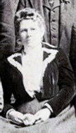
Mary Jane Gierhart Wood
| Birth | : | 19 Jul 1842 Ohio, USA |
| Death | : | 30 Mar 1920 Chelan, Chelan County, Washington, USA |
| Burial | : | Lakeview Cemetery, Kenmare, Ward County, USA |
| Coordinate | : | 48.6627998, -102.1016998 |
| Plot | : | South Fraternal |
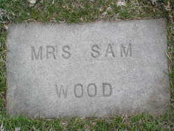
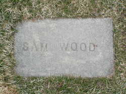
| Description | : | 1920 census states Mary J. b: abt 1837 in Illinois but early records indicate Ohio. m: Ross Colwell 6 Feb 1865 in Stark Co, IL child: Ida Colwell b: abt 1868 m: John F Allen 29 Sep 1892 in Des Moines, Polk Co, IA m: ? Horter/Foster m: Sam Wood 28 Oct 1912 in Chelan, Chelan Co, WA Washington Death Certificate Name Mary Jane Wood Death date 30 Mar 1920 Death place Chelan, Chelan, Washington, United States Gender Female Estimated birth year 1848 Marital status Married Spouse name... Read More |
frequently asked questions (FAQ):
-
Where is Mary Jane Gierhart Wood's memorial?
Mary Jane Gierhart Wood's memorial is located at: Lakeview Cemetery, Kenmare, Ward County, USA.
-
When did Mary Jane Gierhart Wood death?
Mary Jane Gierhart Wood death on 30 Mar 1920 in Chelan, Chelan County, Washington, USA
-
Where are the coordinates of the Mary Jane Gierhart Wood's memorial?
Latitude: 48.6627998
Longitude: -102.1016998
Family Members:
Parent
Spouse
Siblings

Flowers:


Nearby Cemetories:
1. Lakeview Cemetery
Kenmare, Ward County, USA
Coordinate: 48.6627998, -102.1016998
2. Saint Agnes Catholic Cemetery
Kenmare, Ward County, USA
Coordinate: 48.6804500, -102.0737200
3. Rose Hill Cemetery
Kenmare, Ward County, USA
Coordinate: 48.6804600, -102.0723200
4. Spring Valley Mennonite Cemetery
Kenaston, Ward County, USA
Coordinate: 48.5904617, -102.0805817
5. Trinity Lutheran Cemetery
Kenmare, Ward County, USA
Coordinate: 48.7335590, -102.0646290
6. Elmdale Lutheran Cemetery
Niobe, Ward County, USA
Coordinate: 48.6988983, -102.2127991
7. Bethany Lutheran Cemetery
Burke County, USA
Coordinate: 48.7349080, -102.1683880
8. Baden Cemetery
Baden, Ward County, USA
Coordinate: 48.5610700, -102.0823000
9. Our Saviors Lutheran Cemetery
Kenaston, Ward County, USA
Coordinate: 48.5604477, -102.1352158
10. Little Butte Cemetery
Bowbells, Burke County, USA
Coordinate: 48.7197310, -102.2769000
11. Coulee Cemetery
Coulee, Mountrail County, USA
Coordinate: 48.5462723, -102.0065536
12. Bethlehem Lutheran Cemetery
Coulee, Mountrail County, USA
Coordinate: 48.5301895, -102.1457291
13. Saint Joseph Cemetery
Bowbells, Burke County, USA
Coordinate: 48.8069000, -102.2266998
14. Bowbells Cemetery
Bowbells, Burke County, USA
Coordinate: 48.8068000, -102.2278100
15. Greenfield Cemetery
Ward County, USA
Coordinate: 48.5974998, -101.8653030
16. Trinity Cemetery
Tolley, Renville County, USA
Coordinate: 48.7261009, -101.8341980
17. Saint Charles Cemetery
Tolley, Renville County, USA
Coordinate: 48.7340012, -101.8345108
18. Zion Lutheran Cemetery
Coulee, Mountrail County, USA
Coordinate: 48.4882300, -102.2240500
19. Nasareth Cemetery
Vanville, Burke County, USA
Coordinate: 48.6180992, -102.3861008
20. Bethlehem Lutheran Cemetery
Bowbells, Burke County, USA
Coordinate: 48.7963982, -102.3236008
21. Zion Lutheran Cemetery
Norma, Renville County, USA
Coordinate: 48.8499184, -101.9987030
22. Hide and Stone Cemetery
Vanville, Burke County, USA
Coordinate: 48.5788000, -102.3792600
23. Donnybrook Community Cemetery
Donnybrook, Ward County, USA
Coordinate: 48.5171165, -101.8895264
24. Holbrook Cemetery
Donnybrook, Ward County, USA
Coordinate: 48.5119019, -101.8944016