
| Birth | : | 28 Dec 1841 Loudoun County, Virginia, USA |
| Death | : | 15 Dec 1908 Dickinson County, Kansas, USA |
| Burial | : | Liberty Cemetery, Upland, Dickinson County, USA |
| Coordinate | : | 39.0896988, -97.0278015 |
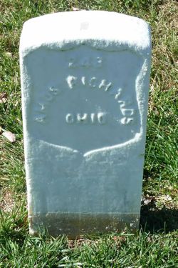
| Description | : | Named: Mary Minerva Cordelia Jane Mull. Married Amos Richards, Harrison County, Ohio on Aug 30, 1857. Children: Samantha Jane and Tabitha Ann. Baby girl died in infancy 1864/65. Mary Jane lost her beloved Amos as a very young woman. By accounts of the Richards family, she was the prettiest girl in the county. She never remarried, but raised her two daughters on a government pension of $12.00 a month, maintaining the home which Amos had purchased in Westchester, Tuscarawas County, Ohio before his induction. She became part of Lemerick and Samantha's household in 1885. Mary Jane and Amos can now be... Read More |
frequently asked questions (FAQ):
-
Where is Mary Jane Mull Richards's memorial?
Mary Jane Mull Richards's memorial is located at: Liberty Cemetery, Upland, Dickinson County, USA.
-
When did Mary Jane Mull Richards death?
Mary Jane Mull Richards death on 15 Dec 1908 in Dickinson County, Kansas, USA
-
Where are the coordinates of the Mary Jane Mull Richards's memorial?
Latitude: 39.0896988
Longitude: -97.0278015
Family Members:
Parent
Spouse
Siblings
Children

Flowers:


Nearby Cemetories:
1. Liberty Cemetery
Upland, Dickinson County, USA
Coordinate: 39.0896988, -97.0278015
2. Alida Zion Evangelical Cemetery
Upland, Dickinson County, USA
Coordinate: 39.0750008, -96.9721985
3. Jones Cemetery
Dickinson County, USA
Coordinate: 39.0703011, -97.0860977
4. Alida Cemetery
Geary County, USA
Coordinate: 39.1030998, -96.9618988
5. Saint Johns Cemetery
Geary County, USA
Coordinate: 39.0741997, -96.9610977
6. Good Hope Cemetery
Chapman, Dickinson County, USA
Coordinate: 39.0388985, -96.9991989
7. Sutphen Mill Cemetery
Chapman, Dickinson County, USA
Coordinate: 39.0330190, -97.0368770
8. Greenridge Cemetery
Dickinson County, USA
Coordinate: 39.1199989, -97.1433029
9. Madura Cemetery
Wakefield, Clay County, USA
Coordinate: 39.1842003, -97.0117035
10. Bethel Cemetery
Moonlight, Dickinson County, USA
Coordinate: 39.0022011, -97.1110535
11. Saint Patricks Cemetery
Chapman, Dickinson County, USA
Coordinate: 38.9803330, -97.0062850
12. Buckeye Cemetery
Buckeye, Dickinson County, USA
Coordinate: 39.0463070, -97.1665840
13. Indian Hill Cemetery
Chapman, Dickinson County, USA
Coordinate: 38.9714012, -97.0327988
14. Henry Cemetery
Buckeye, Dickinson County, USA
Coordinate: 39.0828018, -97.1857986
15. Branscom Cemetery
Milford, Geary County, USA
Coordinate: 39.1627998, -96.8942032
16. Barry Cemetery
Milford, Geary County, USA
Coordinate: 39.1889000, -96.9218979
17. Highland Cemetery
Wakefield, Clay County, USA
Coordinate: 39.2190247, -97.0133667
18. Milford Cemetery
Milford, Geary County, USA
Coordinate: 39.1828003, -96.9047012
19. Timber Creek Cemetery
Wakefield, Clay County, USA
Coordinate: 39.2182999, -96.9805984
20. Saint John's Episcopal Cemetery
Clay County, USA
Coordinate: 39.2193985, -97.0744019
21. Mizpah Cemetery
Clay County, USA
Coordinate: 39.2057800, -97.1238500
22. Union Cemetery
Buckeye, Dickinson County, USA
Coordinate: 39.0243988, -97.1856003
23. Athelstane Cemetery
Athelstane Township, Clay County, USA
Coordinate: 39.1768990, -97.1753006
24. Geary County Poor Farm Cemetery
Junction City, Geary County, USA
Coordinate: 39.0064500, -96.8727100