
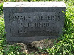
Mary L. Dreher Shepherd
| Birth | : | 1871 Tecumseh, Vigo County, Indiana, USA |
| Death | : | 1967 Tecumseh, Vigo County, Indiana, USA |
| Burial | : | Forest Park Cemetery, Fort Smith, Sebastian County, USA |
| Coordinate | : | 35.4261017, -94.3719025 |
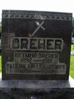
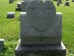
| Description | : | Mary, called "Mame" by her family, was the daughter of Ottmar and Pauline (Miller) Dreher. On Oct., 18, 1898 she married George W. Shepherd, but he died just six months later. She moved back to her parents' home, never married again and lived to 96 years of age. |
frequently asked questions (FAQ):
-
Where is Mary L. Dreher Shepherd's memorial?
Mary L. Dreher Shepherd's memorial is located at: Forest Park Cemetery, Fort Smith, Sebastian County, USA.
-
When did Mary L. Dreher Shepherd death?
Mary L. Dreher Shepherd death on 1967 in Tecumseh, Vigo County, Indiana, USA
-
Where are the coordinates of the Mary L. Dreher Shepherd's memorial?
Latitude: 35.4261017
Longitude: -94.3719025
Family Members:
Parent

Spouse
Siblings
Flowers:


Nearby Cemetories:
1. Forest Park Cemetery
Fort Smith, Sebastian County, USA
Coordinate: 35.4261017, -94.3719025
2. Nolon Springs Cemetery
Fort Smith, Sebastian County, USA
Coordinate: 35.4291992, -94.3843994
3. Washington Cemetery
Fort Smith, Sebastian County, USA
Coordinate: 35.4095980, -94.3713360
4. Fairview Cemetery
Van Buren, Crawford County, USA
Coordinate: 35.4411011, -94.3503036
5. Holy Cross Cemetery
Fort Smith, Sebastian County, USA
Coordinate: 35.3978004, -94.3685989
6. Trinity Columbarium
Van Buren, Crawford County, USA
Coordinate: 35.4484650, -94.3496980
7. Crown Hill Cemetery
Van Buren, Crawford County, USA
Coordinate: 35.4337910, -94.3329620
8. Rose Lawn Park Cemetery
Fort Smith, Sebastian County, USA
Coordinate: 35.3917007, -94.3700027
9. RoseLawn Park Columbarium
Fort Smith, Sebastian County, USA
Coordinate: 35.3917000, -94.3700000
10. Gracelawn Cemetery
Van Buren, Crawford County, USA
Coordinate: 35.4462500, -94.3268500
11. Foster Cemetery
Van Buren, Crawford County, USA
Coordinate: 35.4755710, -94.3731370
12. First United Methodist Church Columbarium
Fort Smith, Sebastian County, USA
Coordinate: 35.3834560, -94.4150440
13. Saint John Episcopal Church Columbarium
Fort Smith, Sebastian County, USA
Coordinate: 35.3895490, -94.4234350
14. First Presbyterian Church Columbarium
Fort Smith, Sebastian County, USA
Coordinate: 35.3849900, -94.4182700
15. Peevyhouse Cemetery
Van Buren, Crawford County, USA
Coordinate: 35.4799995, -94.3925018
16. Gill Cemetery
Van Buren, Crawford County, USA
Coordinate: 35.4353676, -94.3029861
17. Saint Scholastica Cemetery
Fort Smith, Sebastian County, USA
Coordinate: 35.3700890, -94.3842790
18. Immaculate Conception Catholic Columbarium
Fort Smith, Sebastian County, USA
Coordinate: 35.3828960, -94.4184930
19. Antioch Cemetery
Van Buren, Crawford County, USA
Coordinate: 35.4771996, -94.3368988
20. Dora Cemetery
Van Buren, Crawford County, USA
Coordinate: 35.4493350, -94.4394630
21. Stevenson Cemetery
Van Buren, Crawford County, USA
Coordinate: 35.4702988, -94.3221970
22. Calvary Cemetery
Fort Smith, Sebastian County, USA
Coordinate: 35.3764000, -94.4167023
23. Oak Cemetery
Fort Smith, Sebastian County, USA
Coordinate: 35.3694000, -94.4017029
24. Jewish Cemetery
Fort Smith, Sebastian County, USA
Coordinate: 35.3757000, -94.4176000