
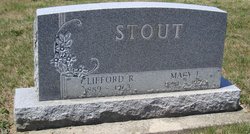
Mary L Frantz Stout
| Birth | : | 29 Apr 1893 |
| Death | : | 13 Nov 1990 |
| Burial | : | St Anne's Parish Church, St Annes, Fylde Borough, England |
| Coordinate | : | 53.7565230, -3.0227100 |
| Description | : | She married Clifford R Stout July 10th, 1909 in Wabash County, Indiana. She was also the mother of Kenneth P, Lester R, and Eugene R. |
frequently asked questions (FAQ):
-
Where is Mary L Frantz Stout's memorial?
Mary L Frantz Stout's memorial is located at: St Anne's Parish Church, St Annes, Fylde Borough, England.
-
When did Mary L Frantz Stout death?
Mary L Frantz Stout death on 13 Nov 1990 in
-
Where are the coordinates of the Mary L Frantz Stout's memorial?
Latitude: 53.7565230
Longitude: -3.0227100
Family Members:
Parent

Spouse

Siblings
Children

Flowers:


Nearby Cemetories:
1. St Anne's Parish Church
St Annes, Fylde Borough, England
Coordinate: 53.7565230, -3.0227100
2. Lytham Park Cemetery and Crematorium
Lytham Saint Annes, Fylde Borough, England
Coordinate: 53.7534410, -2.9825790
3. St. Cuthbert Churchyard
Lytham Saint Annes, Fylde Borough, England
Coordinate: 53.7376560, -2.9761270
4. Holy Trinity Churchyard
Blackpool, Blackpool Unitary Authority, England
Coordinate: 53.7962949, -3.0536214
5. St John the Divine
Lytham Saint Annes, Fylde Borough, England
Coordinate: 53.7367060, -2.9548070
6. Marton Burial Ground
Great Marton, Blackpool Unitary Authority, England
Coordinate: 53.8030870, -3.0108350
7. Saltcoates Roman Catholic Cemetery
Lytham Saint Annes, Fylde Borough, England
Coordinate: 53.7463000, -2.9448940
8. Saint Paul Churchyard
Great Marton, Blackpool Unitary Authority, England
Coordinate: 53.8053220, -3.0268330
9. Carlton Cemetery& Crematorium
Blackpool, Blackpool Unitary Authority, England
Coordinate: 53.8095921, -3.0364920
10. St John the Evangelist Churchyard
Blackpool, Blackpool Unitary Authority, England
Coordinate: 53.8182303, -3.0508197
11. St. Anne's Roman Catholic Churchyard
Westby, Fylde Borough, England
Coordinate: 53.7876590, -2.9247000
12. St Nicholas Churchyard
Wrea Green, Fylde Borough, England
Coordinate: 53.7772420, -2.9156380
13. St Michael Churchyard
Weeton, Fylde Borough, England
Coordinate: 53.7995380, -2.9358020
14. Layton Cemetery
Blackpool, Blackpool Unitary Authority, England
Coordinate: 53.8273740, -3.0328240
15. Blackpool Jewish Cemetery
Blackpool, Blackpool Unitary Authority, England
Coordinate: 53.8287397, -3.0311753
16. St Paul's Church & Medical Centre
Blackpool Unitary Authority, England
Coordinate: 53.8291540, -3.0533490
17. Parish Church of St. Paul
Warton, Fylde Borough, England
Coordinate: 53.7502621, -2.8932641
18. Saint John the Evangelist Churchyard
Kirkham, Fylde Borough, England
Coordinate: 53.7808000, -2.8873870
19. St Stephen On-the-Cliffs Churchyard
Blackpool, Blackpool Unitary Authority, England
Coordinate: 53.8407230, -3.0515610
20. Saint Joseph's Roman Catholic Church
Wesham, Fylde Borough, England
Coordinate: 53.7928600, -2.8871800
21. Christ Church Churchyard
Wesham, Fylde Borough, England
Coordinate: 53.7905000, -2.8845600
22. Blackpool Cemetery and Crematorium
Poulton-le-Fylde, Wyre Borough, England
Coordinate: 53.8465680, -3.0196600
23. Holy Trinity Churchyard
Freckleton, Fylde Borough, England
Coordinate: 53.7543090, -2.8669130
24. Saint Chad Churchyard
Poulton-le-Fylde, Wyre Borough, England
Coordinate: 53.8471992, -2.9925005