
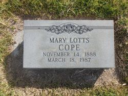
| Birth | : | Nov 1888 |
| Death | : | 3 Mar 1987 Pawnee City, Pawnee County, Nebraska, USA |
| Burial | : | Oakwood Cemetery, Red Wing, Goodhue County, USA |
| Coordinate | : | 44.5544250, -92.5223270 |
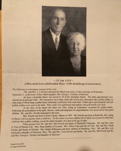
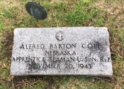
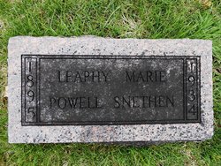
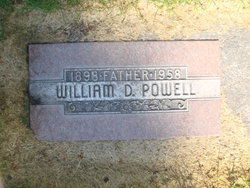
| Description | : | Mary L. Powell Cope, born November 1888 to John J. Powell and Ion Hellena Lotts, married Alfred Barton Cope on November 16, 1916 in Harrison, Nebraska, died March 3, 1987 in Pawnee City, Pawnee County, Nebraska, buried in Pawnee City Cemetery. |
frequently asked questions (FAQ):
-
Where is Mary L. Powell Cope's memorial?
Mary L. Powell Cope's memorial is located at: Oakwood Cemetery, Red Wing, Goodhue County, USA.
-
When did Mary L. Powell Cope death?
Mary L. Powell Cope death on 3 Mar 1987 in Pawnee City, Pawnee County, Nebraska, USA
-
Where are the coordinates of the Mary L. Powell Cope's memorial?
Latitude: 44.5544250
Longitude: -92.5223270
Family Members:
Parent

Spouse
Siblings
Children
Flowers:


Nearby Cemetories:
1. Oakwood Cemetery
Red Wing, Goodhue County, USA
Coordinate: 44.5544250, -92.5223270
2. Calvary Cemetery
Red Wing, Goodhue County, USA
Coordinate: 44.5430984, -92.5211029
3. Saint Johns Cemetery
Red Wing, Goodhue County, USA
Coordinate: 44.5657997, -92.5697021
4. Trenton Cemetery
Trenton, Pierce County, USA
Coordinate: 44.5917015, -92.5447006
5. Scherf Cemetery
Wacouta, Goodhue County, USA
Coordinate: 44.5111084, -92.4777832
6. Poor Farm Cemetery
Red Wing, Goodhue County, USA
Coordinate: 44.5750008, -92.5930634
7. Bay City Cemetery
Bay City, Pierce County, USA
Coordinate: 44.5877800, -92.4555588
8. Immanuel Lutheran Church Cemetery
Hay Creek, Goodhue County, USA
Coordinate: 44.4913902, -92.5363922
9. Hay Creek German Methodist Cemetery
Goodhue County, USA
Coordinate: 44.4917908, -92.5437469
10. Wacouta Cemetery
Wacouta, Goodhue County, USA
Coordinate: 44.5477791, -92.4291687
11. Burnside Cemetery
Red Wing, Goodhue County, USA
Coordinate: 44.5677986, -92.6168976
12. Christiansen Dairy Farm Cemetery
Hager City, Pierce County, USA
Coordinate: 44.6225610, -92.5574390
13. Svea Lutheran Cemetery
Trenton, Pierce County, USA
Coordinate: 44.6341362, -92.5168533
14. Old Wells Creek Cemetery
Goodhue County, USA
Coordinate: 44.4846992, -92.4431000
15. Messiah Episcopal Cemetery
Harliss, Goodhue County, USA
Coordinate: 44.5427818, -92.6483307
16. Darrington Cemetery
Hartland, Pierce County, USA
Coordinate: 44.6283500, -92.4357000
17. Mount Tabor Cemetery
Oakridge, Pierce County, USA
Coordinate: 44.5868988, -92.3949966
18. Eidsvold Lutheran Cemetery
Esdaile, Pierce County, USA
Coordinate: 44.6308400, -92.4381700
19. Mount Carmel Cemetery
Goodhue County, USA
Coordinate: 44.5966988, -92.6613998
20. Belvidere Union Cemetery
Belvidere Mills, Goodhue County, USA
Coordinate: 44.4486008, -92.4916992
21. Hope Cemetery
Red Wing, Goodhue County, USA
Coordinate: 44.4831009, -92.6367035
22. Diamond Bluff Cemetery
Diamond Bluff, Pierce County, USA
Coordinate: 44.6417007, -92.6153030
23. Hartland Presbyterian Cemetery
Ellsworth, Pierce County, USA
Coordinate: 44.6604729, -92.4793015
24. Hartland Methodist Cemetery
Esdaile, Pierce County, USA
Coordinate: 44.6227455, -92.3962936