
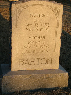
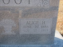
Mary Louise Belveal Barton
| Birth | : | 28 Nov 1860 Shelby County, Indiana, USA |
| Death | : | 19 Jan 1928 Lucas, Russell County, Kansas, USA |
| Burial | : | Hokitika Municipal Cemetery, Hokitika, Westland District, New Zealand |
| Coordinate | : | -42.7102940, 170.9759800 |
| Description | : | Mary Louise Belveal was not yet two years old in the summer of 1862 when her father Landon enlisted in the Union Army and joined Company G of the 5th Indiana Cavalry Regiment. In December of that year, Landon Belveal was discharged due to wounds received. By 1870, the family, including seven children, was heading west from Indiana, by way of Iowa, to claim a homestead near modern Tipton, Mitchell County, Kansas. This was 200 miles west of Kansas City and still open range for the great bison herds and non-reservation plains Indians. According to a family story, when Mary... Read More |
frequently asked questions (FAQ):
-
Where is Mary Louise Belveal Barton's memorial?
Mary Louise Belveal Barton's memorial is located at: Hokitika Municipal Cemetery, Hokitika, Westland District, New Zealand.
-
When did Mary Louise Belveal Barton death?
Mary Louise Belveal Barton death on 19 Jan 1928 in Lucas, Russell County, Kansas, USA
-
Where are the coordinates of the Mary Louise Belveal Barton's memorial?
Latitude: -42.7102940
Longitude: 170.9759800
Family Members:
Parent
Spouse
Siblings

Children
Flowers:


Nearby Cemetories:
1. Hokitika Municipal Cemetery
Hokitika, Westland District, New Zealand
Coordinate: -42.7102940, 170.9759800
2. Old Stafford Cemetery
Hokitika, Westland District, New Zealand
Coordinate: -42.6662370, 171.0893140
3. Kumara Cemetery
Kumara, Westland District, New Zealand
Coordinate: -42.6464650, 171.1721970
4. Ross Cemetery
Ross, Westland District, New Zealand
Coordinate: -42.8898440, 170.8226160
5. Gladstone Cemetery
Greymouth, Grey District, New Zealand
Coordinate: -42.5381220, 171.1522540
6. Ross Historic Cemetery
Ross, Westland District, New Zealand
Coordinate: -42.9023200, 170.8113230
7. Greenstone Cemetery
Kumara, Westland District, New Zealand
Coordinate: -42.6361450, 171.2751350
8. Karoro Cemetery
Greymouth, Grey District, New Zealand
Coordinate: -42.4678260, 171.1893800
9. St Pauls Methodist Church (Defunct)
Greymouth, Grey District, New Zealand
Coordinate: -42.4500880, 171.2114610
10. Cobden Cemetery
Greymouth, Grey District, New Zealand
Coordinate: -42.4371700, 171.2019000
11. Stillwater Cemetery
Greymouth, Grey District, New Zealand
Coordinate: -42.4394820, 171.3494380
12. Notown Cemetery
Dobson, Grey District, New Zealand
Coordinate: -42.4514530, 171.4465670
13. Blackball Cemetery
Greymouth, Grey District, New Zealand
Coordinate: -42.3757410, 171.4135760
14. Evans Grave
Arthurs Pass, Selwyn District, New Zealand
Coordinate: -42.7723610, 171.6249940
15. Nelson Creek Cemetery
Ngahere, Grey District, New Zealand
Coordinate: -42.3865620, 171.4595500
16. Barrytown Cemetery
Barrytown, Grey District, New Zealand
Coordinate: -42.2455150, 171.3166710
17. Hari Hari Cemetery
Hari Hari, Westland District, New Zealand
Coordinate: -43.1501430, 170.5576110
18. Ahaura Cemetery
Ahaura, Grey District, New Zealand
Coordinate: -42.3516790, 171.5581700
19. Whataroa Cemetery
Whataroa, Westland District, New Zealand
Coordinate: -43.2530190, 170.3587130
20. Lake Coleridge Cemetery
Lake Coleridge, Selwyn District, New Zealand
Coordinate: -43.3695530, 171.5264300
21. Charleston Catholic Cemetery
Charleston, Buller District, New Zealand
Coordinate: -41.9093390, 171.4359110
22. Nile Hill Cemetery
Charleston, Buller District, New Zealand
Coordinate: -41.8991610, 171.4394080
23. Old Reefton Cemetery
Reefton, Buller District, New Zealand
Coordinate: -42.1115220, 171.8590850
24. Reefton Cemetery
Reefton, Buller District, New Zealand
Coordinate: -42.0856940, 171.8470730