
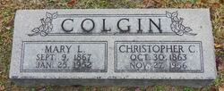
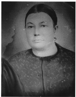
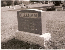
Mary Lucretia Gillham Colgin
| Birth | : | 9 Sep 1867 |
| Death | : | 25 Jan 1952 Bayard, Allen County, Kansas, USA |
| Burial | : | Brooke Cemetery, Wellsburg, Brooke County, USA |
| Coordinate | : | 40.2874985, -80.6053009 |
frequently asked questions (FAQ):
-
Where is Mary Lucretia Gillham Colgin's memorial?
Mary Lucretia Gillham Colgin's memorial is located at: Brooke Cemetery, Wellsburg, Brooke County, USA.
-
When did Mary Lucretia Gillham Colgin death?
Mary Lucretia Gillham Colgin death on 25 Jan 1952 in Bayard, Allen County, Kansas, USA
-
Where are the coordinates of the Mary Lucretia Gillham Colgin's memorial?
Latitude: 40.2874985
Longitude: -80.6053009
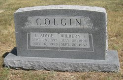
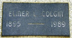
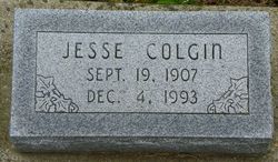
Family Members:
Parent
Spouse

Siblings
Children

Flowers:


Nearby Cemetories:
1. Brooke Cemetery
Wellsburg, Brooke County, USA
Coordinate: 40.2874985, -80.6053009
2. Knights of Saint George Cemetery
Wellsburg, Brooke County, USA
Coordinate: 40.2859920, -80.5989860
3. Brooke County Public Library Cremation Niches
Wellsburg, Brooke County, USA
Coordinate: 40.2725410, -80.6128480
4. Georges Run Cemetery
Steubenville, Jefferson County, USA
Coordinate: 40.3022920, -80.6189630
5. St John's Cemetery
Brooke County, USA
Coordinate: 40.2697156, -80.5840881
6. Cross Creek Cemetery
Brooke County, USA
Coordinate: 40.3060989, -80.5792007
7. Ebenezer Church Cemetery
Brooke County, USA
Coordinate: 40.3071090, -80.5622320
8. Saint Andrews Cemetery
Mingo Junction, Jefferson County, USA
Coordinate: 40.3250008, -80.6172028
9. Oakland Cemetery
Mingo Junction, Jefferson County, USA
Coordinate: 40.3285790, -80.6184240
10. Hill Cemetery
Steubenville, Jefferson County, USA
Coordinate: 40.3233490, -80.6353580
11. Oak Grove Cemetery
Follansbee, Brooke County, USA
Coordinate: 40.3274994, -80.5766983
12. Franklin Cemetery
Franklin, Brooke County, USA
Coordinate: 40.2758800, -80.5449300
13. Unidentified Cemetery
McKinleyville, Brooke County, USA
Coordinate: 40.2402083, -80.5980333
14. Buckingham Cemetery
Wells Township, Jefferson County, USA
Coordinate: 40.2739230, -80.6662180
15. New Alexandria Cemetery
New Alexandria, Jefferson County, USA
Coordinate: 40.2949982, -80.6781006
16. Everson Family Cemetery
Salt Run, Jefferson County, USA
Coordinate: 40.2492340, -80.6633810
17. McGee-Stringers Cemetery
Wells Township, Jefferson County, USA
Coordinate: 40.2431440, -80.6590810
18. Wells Cemetery
Beech Bottom, Brooke County, USA
Coordinate: 40.2221985, -80.6322021
19. Highland Hills Memorial Gardens
Follansbee, Brooke County, USA
Coordinate: 40.3579480, -80.6038500
20. Lower Buffalo Cemetery
Brooke County, USA
Coordinate: 40.2435989, -80.5297012
21. Saint John Cemetery Haven of Rest
Colliers, Brooke County, USA
Coordinate: 40.3486160, -80.5502720
22. Union Cemetery
Steubenville, Jefferson County, USA
Coordinate: 40.3636017, -80.6399994
23. Cross Creek United Presbyterian Church Cemetery
Colliers, Brooke County, USA
Coordinate: 40.3458430, -80.5316650
24. Mount Calvary Cemetery
Steubenville, Jefferson County, USA
Coordinate: 40.3643990, -80.6466980