
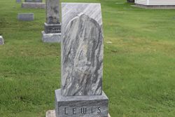

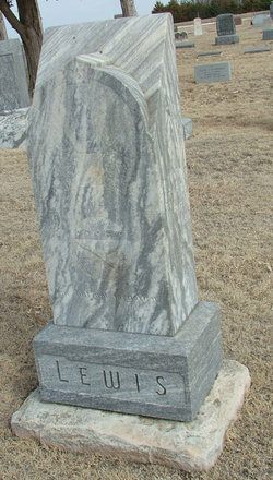
Mary Lucy Clark Lewis
| Birth | : | 26 Jun 1861 Knoxville, Ray County, Missouri, USA |
| Death | : | 15 Mar 1943 Smith Center, Smith County, Kansas, USA |
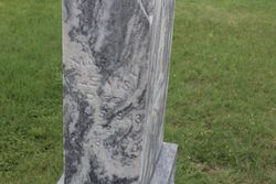
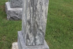
| Burial | : | Ash Rock Cemetery, Woodston, Rooks County, USA |
| Coordinate | : | 39.5248909, -99.0817719 |
| Description | : | Mary Lucy Clark's parents were: Alexander Matthew Clark of Clark's Summit, Wythe County, VA and Louisa Ann Peterman. According to the Clark family Bible (of which I have dates of all the recorded entries from 1965 which was sent to me by Mary Stuart of Texas who had the Bible) Alexander Matthew was born was born November, 20, 1837 and died May 10, 1864 at Fort Delaware, Maryland (Civil War Union prison) of fever. His father was John Clark (March 1, 1782-July 25, 1865) and Mary Rebecca Seybert (June 24, 1787-June 24, 1829). The Bible also states "Alexander M. Clark... Read More |
frequently asked questions (FAQ):
-
Where is Mary Lucy Clark Lewis's memorial?
Mary Lucy Clark Lewis's memorial is located at: Ash Rock Cemetery, Woodston, Rooks County, USA.
-
When did Mary Lucy Clark Lewis death?
Mary Lucy Clark Lewis death on 15 Mar 1943 in Smith Center, Smith County, Kansas, USA
-
Where are the coordinates of the Mary Lucy Clark Lewis's memorial?
Latitude: 39.5248909
Longitude: -99.0817719
Family Members:
Spouse
Children

Flowers:


Nearby Cemetories:
1. Ash Rock Cemetery
Woodston, Rooks County, USA
Coordinate: 39.5248909, -99.0817719
2. Spring Branch Cemetery
Woodston, Rooks County, USA
Coordinate: 39.5099983, -99.0580978
3. Pleasant Ridge Cemetery
Kirwin, Phillips County, USA
Coordinate: 39.5963000, -99.1234000
4. Grant Center Cemetery
Alton, Osborne County, USA
Coordinate: 39.5242004, -98.9708023
5. Pleasant Valley Cemetery
Osborne County, USA
Coordinate: 39.4583015, -99.0077972
6. Woodston Cemetery
Woodston, Rooks County, USA
Coordinate: 39.4375000, -99.1268997
7. Pioneer Cemetery
Alton, Osborne County, USA
Coordinate: 39.4742012, -98.9749985
8. Bohemian Cemetery
Claudell, Smith County, USA
Coordinate: 39.6187800, -99.0428200
9. Leasburg Cemetery
Cedar, Smith County, USA
Coordinate: 39.5819016, -98.9728012
10. West Hope Cemetery
Rooks County, USA
Coordinate: 39.5024986, -99.2110977
11. Greenwood Cemetery
Kirwin, Phillips County, USA
Coordinate: 39.5931900, -99.2064600
12. Sumner Cemetery
Alton, Osborne County, USA
Coordinate: 39.4799995, -98.9338913
13. Saint Francis Catholic Cemetery
Cedar, Smith County, USA
Coordinate: 39.6328011, -98.9816971
14. Bow Creek Cemetery
Glade, Phillips County, USA
Coordinate: 39.5681000, -99.2696991
15. Survey Cemetery
Woodston, Rooks County, USA
Coordinate: 39.3722000, -99.1333008
16. Kirwin Cemetery
Kirwin, Phillips County, USA
Coordinate: 39.6781006, -99.1421967
17. Stockton Cemetery
Stockton, Rooks County, USA
Coordinate: 39.4406700, -99.2647400
18. Saint Thomas Cemetery
Stockton, Rooks County, USA
Coordinate: 39.4449997, -99.2771988
19. Mount Ayr Cemetery
Alton, Osborne County, USA
Coordinate: 39.3764000, -98.9717026
20. Butler Cemetery
Osborne County, USA
Coordinate: 39.5400009, -98.8494034
21. Old Stockton Cemetery
Stockton, Rooks County, USA
Coordinate: 39.4597015, -99.3050003
22. Cedar Cemetery
Cedar, Smith County, USA
Coordinate: 39.6685982, -98.9310989
23. Bigge Family Cemetery
Stockton, Rooks County, USA
Coordinate: 39.4584700, -99.3053200
24. Pleasant Plain Cemetery
Osborne County, USA
Coordinate: 39.3367004, -99.0372009