

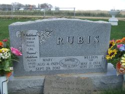
Mary M Guess Rubis
| Birth | : | 4 Aug 1929 Plover, Pocahontas County, Iowa, USA |
| Death | : | 28 Sep 2012 Mesa, Maricopa County, Arizona, USA |
| Burial | : | Fairview Cemetery, Terril, Dickinson County, USA |
| Coordinate | : | 43.2977982, -94.9349976 |
| Description | : | Aug. 4, 1929 -- Sept. 28, 2012 Longtime Terril resident Mary Rubis passed away Sept. 28, 2012 in Mesa, Ariz. Mary M Guess was born Aug. 4, 1929, in rural Plover, Iowa, the daughter of Earl C. Guess and May Q. (Smith) Guess. After graduating from Plover High School in 1947, she attended Iowa State Teachers' College in Cedar Falls to become a primary education teacher. She taught first grade at Terril Community School for one year and substituted during the following years. She then worked as a bookkeeper at the Terril Farmer's Cooperative Elevator for over 30 years. On... Read More |
frequently asked questions (FAQ):
-
Where is Mary M Guess Rubis's memorial?
Mary M Guess Rubis's memorial is located at: Fairview Cemetery, Terril, Dickinson County, USA.
-
When did Mary M Guess Rubis death?
Mary M Guess Rubis death on 28 Sep 2012 in Mesa, Maricopa County, Arizona, USA
-
Where are the coordinates of the Mary M Guess Rubis's memorial?
Latitude: 43.2977982
Longitude: -94.9349976
Family Members:
Spouse
Children
Flowers:


Nearby Cemetories:
1. Fairview Cemetery
Terril, Dickinson County, USA
Coordinate: 43.2977982, -94.9349976
2. Richland Township Cemetery
Terril, Dickinson County, USA
Coordinate: 43.3565323, -94.9927821
3. Saint Patricks Cemetery
Estherville, Emmet County, USA
Coordinate: 43.3843994, -94.8283005
4. Oak Hill Cemetery
Estherville, Emmet County, USA
Coordinate: 43.3986015, -94.8518982
5. Wallingford Lutheran Cemetery
Wallingford, Emmet County, USA
Coordinate: 43.3128014, -94.7731018
6. Lost Island Lutheran Cemetery
Lost Island Township, Palo Alto County, USA
Coordinate: 43.1980000, -94.8375000
7. Graettinger City Cemetery
Graettinger, Palo Alto County, USA
Coordinate: 43.2550011, -94.7722015
8. Saint Jacobs Cemetery
Graettinger, Palo Alto County, USA
Coordinate: 43.2546997, -94.7705994
9. East Side Cemetery
Estherville, Emmet County, USA
Coordinate: 43.4068985, -94.8264008
10. Superior Township Cemetery
Superior, Dickinson County, USA
Coordinate: 43.4399986, -94.9533005
11. Fairview Cemetery
Clay County, USA
Coordinate: 43.1899986, -95.0800018
12. East Side Memorial Cemetery
Estherville, Emmet County, USA
Coordinate: 43.4267750, -94.8265600
13. Norwegian Cemetery
Estherville, Emmet County, USA
Coordinate: 43.4291992, -94.8261032
14. Estherville Lutheran Cemetery
Estherville, Emmet County, USA
Coordinate: 43.4298000, -94.8263000
15. Saint Paul Lutheran Cemetery
Walnut Township, Palo Alto County, USA
Coordinate: 43.1866740, -94.7872050
16. Bedell Gravesite
Spirit Lake, Dickinson County, USA
Coordinate: 43.4128430, -95.0773690
17. Milford Cemetery
Milford, Dickinson County, USA
Coordinate: 43.3092003, -95.1481018
18. Okoboji Cemetery
Arnolds Park, Dickinson County, USA
Coordinate: 43.3649406, -95.1303558
19. Highland Cemetery
Highland Township, Palo Alto County, USA
Coordinate: 43.1497002, -94.8578033
20. Lakeview Gardens Cemetery
Spirit Lake, Dickinson County, USA
Coordinate: 43.3925000, -95.1119000
21. Rose Hill Cemetery (Defunct)
Spirit Lake, Dickinson County, USA
Coordinate: 43.4077600, -95.0976130
22. Pioneer Cemetery
Arnolds Park, Dickinson County, USA
Coordinate: 43.3655000, -95.1403000
23. Gardner Family Cemetery
Arnolds Park, Dickinson County, USA
Coordinate: 43.3654410, -95.1403480
24. Valley View Cemetery
Walnut Township, Palo Alto County, USA
Coordinate: 43.2428000, -94.7212000