
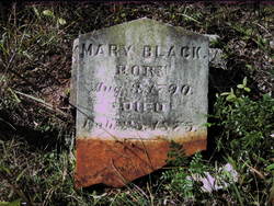
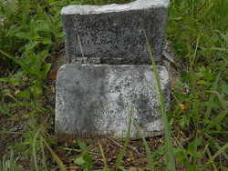
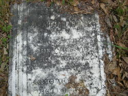
Mary McDowell Black
| Birth | : | 3 Aug 1790 County Antrim, Northern Ireland |
| Death | : | 25 Feb 1875 West Springs, Union County, South Carolina, USA |
| Burial | : | New Row Methodist Church, Blackburn with Darwen Unitary Authority, England |
| Coordinate | : | 53.7208950, -2.5023720 |
| Description | : | Also the mother of Mary Ann Black McDowell who is buried at Fairforest. Find A Grave Memorial# 10319817 Mary McDowell Black survived her husband by 46 years and died in her 85th year. Her pastor wrote: "Truly a mother in Israel and a veteran in the Christian army has gone to her rest. She was ever the preachers' friend and one of those quiet, earnest, faithful, hopeful, praying Christians whose value every minister of the gospel appreciates and whose loss he deeply realizes. Would to God there were more of them in all of our churches." |
frequently asked questions (FAQ):
-
Where is Mary McDowell Black's memorial?
Mary McDowell Black's memorial is located at: New Row Methodist Church, Blackburn with Darwen Unitary Authority, England.
-
When did Mary McDowell Black death?
Mary McDowell Black death on 25 Feb 1875 in West Springs, Union County, South Carolina, USA
-
Where are the coordinates of the Mary McDowell Black's memorial?
Latitude: 53.7208950
Longitude: -2.5023720
Family Members:
Parent
Spouse
Siblings
Children
Flowers:


Nearby Cemetories:
1. New Row Methodist Church
Blackburn with Darwen Unitary Authority, England
Coordinate: 53.7208950, -2.5023720
2. St Stephen Churchyard
Tockholes, Blackburn with Darwen Unitary Authority, England
Coordinate: 53.7058350, -2.5169320
3. St James Churchyard
Lower Darwen, Blackburn with Darwen Unitary Authority, England
Coordinate: 53.7245510, -2.4634700
4. St. Peter's Churchyard
Blackburn, Blackburn with Darwen Unitary Authority, England
Coordinate: 53.7448110, -2.4865070
5. Independent Chapel Churchyard
Blackburn, Blackburn with Darwen Unitary Authority, England
Coordinate: 53.7454960, -2.4864460
6. Pleasington Cemetery and Crematorium
Blackburn, Blackburn with Darwen Unitary Authority, England
Coordinate: 53.7388880, -2.5368710
7. Wesleyan Methodist Chapel Chapelyard
Blackburn, Blackburn with Darwen Unitary Authority, England
Coordinate: 53.7464910, -2.4848380
8. Pleasington Priory
Pleasington, Blackburn with Darwen Unitary Authority, England
Coordinate: 53.7348590, -2.5433060
9. Blackburn Cathedral
Blackburn, Blackburn with Darwen Unitary Authority, England
Coordinate: 53.7472960, -2.4820020
10. St Paul's
Blackburn, Blackburn with Darwen Unitary Authority, England
Coordinate: 53.7491222, -2.4891266
11. Mount St Presbyterian Chapelyard
Blackburn, Blackburn with Darwen Unitary Authority, England
Coordinate: 53.7478000, -2.4775000
12. St Peters Churchyard
Darwen, Blackburn with Darwen Unitary Authority, England
Coordinate: 53.6955520, -2.4648090
13. Holy Trinity Church
Blackburn with Darwen Unitary Authority, England
Coordinate: 53.7511727, -2.4747178
14. St Alban's Churchyard
Blackburn, Blackburn with Darwen Unitary Authority, England
Coordinate: 53.7530090, -2.4748540
15. St Paul's Churchyard
Withnell, Chorley Borough, England
Coordinate: 53.6970740, -2.5592150
16. St. Paul's Churchyard
Darwen, Blackburn with Darwen Unitary Authority, England
Coordinate: 53.6979270, -2.4318640
17. Blackburn Cemetery
Blackburn, Blackburn with Darwen Unitary Authority, England
Coordinate: 53.7662430, -2.4726050
18. Holy Trinity Churchyard
Hoghton, Chorley Borough, England
Coordinate: 53.7279300, -2.5848550
19. Darwen Cemetery
Darwen, Blackburn with Darwen Unitary Authority, England
Coordinate: 53.6781400, -2.4598300
20. Darwen Eastern Cemetery
Darwen, Blackburn with Darwen Unitary Authority, England
Coordinate: 53.6769300, -2.4547700
21. St. Josephs Roman Catholic Churchyard
Brindle, Chorley Borough, England
Coordinate: 53.7350780, -2.5880640
22. Pickup Bank Congregational Chapel
Pickup Bank, Blackburn with Darwen Unitary Authority, England
Coordinate: 53.7012440, -2.4164220
23. St. Mary's Churchyard
Mellor, Ribble Valley Borough, England
Coordinate: 53.7728600, -2.5312400
24. Mellor Methodist Churchyard
Blackburn, Blackburn with Darwen Unitary Authority, England
Coordinate: 53.7742950, -2.5255060