

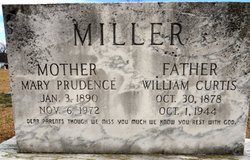
Mary Prudence “Prudie” Hargrove Miller
| Birth | : | 3 Jan 1890 North Carolina, USA |
| Death | : | 6 Nov 1972 Kenansville, Duplin County, North Carolina, USA |
| Burial | : | Ash Valley Cemetery, Pawnee County, USA |
| Coordinate | : | 38.2905998, -99.2174988 |
| Description | : | Wife of William Curtis Miller |
frequently asked questions (FAQ):
-
Where is Mary Prudence “Prudie” Hargrove Miller's memorial?
Mary Prudence “Prudie” Hargrove Miller's memorial is located at: Ash Valley Cemetery, Pawnee County, USA.
-
When did Mary Prudence “Prudie” Hargrove Miller death?
Mary Prudence “Prudie” Hargrove Miller death on 6 Nov 1972 in Kenansville, Duplin County, North Carolina, USA
-
Where are the coordinates of the Mary Prudence “Prudie” Hargrove Miller's memorial?
Latitude: 38.2905998
Longitude: -99.2174988
Family Members:
Parent
Spouse
Siblings
Children

Flowers:


Nearby Cemetories:
1. Ash Valley Cemetery
Pawnee County, USA
Coordinate: 38.2905998, -99.2174988
2. Fort Larned Cemetery
Larned, Pawnee County, USA
Coordinate: 38.1839100, -99.2163200
3. Larned Cemetery
Larned, Pawnee County, USA
Coordinate: 38.1861000, -99.1333008
4. Larned State Hospital Cemetery
Larned, Pawnee County, USA
Coordinate: 38.1722800, -99.1566200
5. Bohemian Cemetery
Timken, Rush County, USA
Coordinate: 38.4441986, -99.1967010
6. Hope Lutheran Cemetery
Rush County, USA
Coordinate: 38.3786070, -99.3831740
7. Rozel Cemetery
Rozel, Pawnee County, USA
Coordinate: 38.2042007, -99.4052963
8. Peace Lutheran Cemetery
Timken, Rush County, USA
Coordinate: 38.3837600, -99.0330750
9. Holy Cross Cemetery
Timken, Rush County, USA
Coordinate: 38.4603004, -99.1791992
10. Pawnee Rock Cemetery
Pawnee Rock, Barton County, USA
Coordinate: 38.2771988, -98.9858017
11. Pawnee Rock State Historic Site
Pawnee Rock, Barton County, USA
Coordinate: 38.2721800, -98.9815300
12. Bergthal Mennonite Cemetery
Pawnee Rock, Barton County, USA
Coordinate: 38.3053017, -98.9772034
13. Saint Pauls Lutheran Cemetery
Albert, Barton County, USA
Coordinate: 38.3770000, -99.0005900
14. Albert Cemetery
Rush County, USA
Coordinate: 38.4213982, -99.0342026
15. Locust Hill Cemetery
Rush Center, Rush County, USA
Coordinate: 38.4728012, -99.3169022
16. Patterson Cemetery
Barton County, USA
Coordinate: 38.4019012, -98.9963989
17. Pioneer Cemetery
Rush County, USA
Coordinate: 38.4643160, -99.0680520
18. Garfield Cemetery
Garfield, Pawnee County, USA
Coordinate: 38.0738983, -99.2667007
19. Union Cemetery
Nekoma, Rush County, USA
Coordinate: 38.4508018, -99.4278030
20. Pleasant Valley Cemetery
Larned, Pawnee County, USA
Coordinate: 38.0718994, -99.0955963
21. Seventh Day Adventist Cemetery
Otis, Rush County, USA
Coordinate: 38.5224991, -99.1252975
22. Lone Star Cemetery
Bison, Rush County, USA
Coordinate: 38.5372009, -99.2181015
23. La Crosse Cemetery
La Crosse, Rush County, USA
Coordinate: 38.5306015, -99.2944031
24. Saint Michaels Cemetery
La Crosse, Rush County, USA
Coordinate: 38.5311012, -99.2960968