
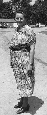

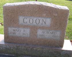
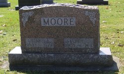
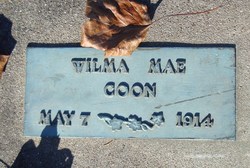
Mary Rebecca Moore Coon
| Birth | : | 12 Apr 1890 Urbana, Wabash County, Indiana, USA |
| Death | : | 13 Jan 1973 Wabash, Wabash County, Indiana, USA |
| Burial | : | North Ensley Cemetery, Ensley Center, Newaygo County, USA |
| Coordinate | : | 43.3671989, -85.5935974 |
| Plot | : | Sec E, lot 35 |
frequently asked questions (FAQ):
-
Where is Mary Rebecca Moore Coon's memorial?
Mary Rebecca Moore Coon's memorial is located at: North Ensley Cemetery, Ensley Center, Newaygo County, USA.
-
When did Mary Rebecca Moore Coon death?
Mary Rebecca Moore Coon death on 13 Jan 1973 in Wabash, Wabash County, Indiana, USA
-
Where are the coordinates of the Mary Rebecca Moore Coon's memorial?
Latitude: 43.3671989
Longitude: -85.5935974
Family Members:
Parent

Spouse
Siblings
Children


Nearby Cemetories:
1. North Ensley Cemetery
Ensley Center, Newaygo County, USA
Coordinate: 43.3671989, -85.5935974
2. Saint Johns Catholic Cemetery
Ensley Center, Newaygo County, USA
Coordinate: 43.3664017, -85.5969009
3. Christian Plains Cemetery
Croton Township, Newaygo County, USA
Coordinate: 43.4100200, -85.6028200
4. Oak Grove Cemetery
Croton Township, Newaygo County, USA
Coordinate: 43.4061012, -85.6430969
5. Bouton Family Farm Burial Site
Reynolds Township, Montcalm County, USA
Coordinate: 43.4294960, -85.5555570
6. Crandall Cemetery
Ensley Center, Newaygo County, USA
Coordinate: 43.2938995, -85.5939026
7. Pierson Township Cemetery
Pierson, Montcalm County, USA
Coordinate: 43.3381004, -85.5006027
8. Surrerar Cemetery
Newaygo, Newaygo County, USA
Coordinate: 43.3949680, -85.7028540
9. Culp Cemetery
Croton Township, Newaygo County, USA
Coordinate: 43.4537900, -85.6078400
10. Stearns Prairie Cemetery
Croton Township, Newaygo County, USA
Coordinate: 43.4543991, -85.5980988
11. Sand Lake Cemetery
Sand Lake, Kent County, USA
Coordinate: 43.2861480, -85.5313380
12. Croton Township Cemetery
Croton, Newaygo County, USA
Coordinate: 43.4394700, -85.6783800
13. Reynolds Township Cemetery
Howard City, Montcalm County, USA
Coordinate: 43.4101300, -85.4767100
14. Saint Marys Catholic Cemetery
Croton, Newaygo County, USA
Coordinate: 43.4677780, -85.6633330
15. Saint Mary's Cemetery
Sand Lake, Kent County, USA
Coordinate: 43.2717018, -85.4969025
16. Hillside Cemetery
Grant, Newaygo County, USA
Coordinate: 43.3222008, -85.7518997
17. Punches Cemetery
Cedar Springs, Kent County, USA
Coordinate: 43.2467003, -85.5317001
18. Solon Township Cemetery
Cedar Springs, Kent County, USA
Coordinate: 43.2344589, -85.6100235
19. Coral Cemetery
Coral, Montcalm County, USA
Coordinate: 43.3671989, -85.4060974
20. Pinewood Cemetery
Tyrone Township, Kent County, USA
Coordinate: 43.2772200, -85.7522200
21. Coady Cemetery
Maple Valley Township, Montcalm County, USA
Coordinate: 43.3540520, -85.3825890
22. Parkview Cemetery
Grant, Newaygo County, USA
Coordinate: 43.3360000, -85.8013370
23. Amble Cemetery
Amble, Montcalm County, USA
Coordinate: 43.4352989, -85.4024963
24. Newaygo Cemetery
Newaygo, Newaygo County, USA
Coordinate: 43.4247220, -85.7927780