
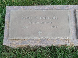
Mary Rosalie Cummins Carroll
| Birth | : | 27 Jun 1897 Maryville, Nodaway County, Missouri, USA |
| Death | : | 1 Dec 1977 Maryville, Nodaway County, Missouri, USA |
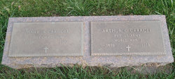
| Burial | : | Saint Pauls Methodist Cemetery, Paulsboro, Gloucester County, USA |
| Coordinate | : | 39.8295700, -75.2396900 |
| Description | : | Wife of Arthur Clyde Carroll, III |
frequently asked questions (FAQ):
-
Where is Mary Rosalie Cummins Carroll's memorial?
Mary Rosalie Cummins Carroll's memorial is located at: Saint Pauls Methodist Cemetery, Paulsboro, Gloucester County, USA.
-
When did Mary Rosalie Cummins Carroll death?
Mary Rosalie Cummins Carroll death on 1 Dec 1977 in Maryville, Nodaway County, Missouri, USA
-
Where are the coordinates of the Mary Rosalie Cummins Carroll's memorial?
Latitude: 39.8295700
Longitude: -75.2396900
Family Members:
Parent
Spouse
Siblings
Children


Nearby Cemetories:
1. Saint Pauls Methodist Cemetery
Paulsboro, Gloucester County, USA
Coordinate: 39.8295700, -75.2396900
2. Mount Vernon Cemetery
Gibbstown, Gloucester County, USA
Coordinate: 39.8209100, -75.2414600
3. Old Stephens Cemetery
West Deptford, Gloucester County, USA
Coordinate: 39.8323970, -75.2179240
4. Saint Peters Cemetery
Mount Royal, Gloucester County, USA
Coordinate: 39.8090130, -75.2130090
5. Zion United Methodist Church Cemetery
Clarksboro, Gloucester County, USA
Coordinate: 39.8030891, -75.2191696
6. Lippincott Cemetery
Clarksboro, Gloucester County, USA
Coordinate: 39.8032460, -75.2138660
7. Alms House Cemetery
Gloucester County, USA
Coordinate: 39.8029980, -75.2142200
8. Eglington Cemetery
Clarksboro, Gloucester County, USA
Coordinate: 39.7980690, -75.2257462
9. Saint Pauls United Methodist Church Cemetery
West Deptford, Gloucester County, USA
Coordinate: 39.8411480, -75.1973650
10. Mickleton Meeting House Graveyard
Mickleton, Gloucester County, USA
Coordinate: 39.7910800, -75.2378900
11. Clonmell Methodist Episcopal Church Cemetery
Gibbstown, Gloucester County, USA
Coordinate: 39.8330000, -75.2940000
12. Gates of Heaven Cemetery
Mount Royal, Gloucester County, USA
Coordinate: 39.7961006, -75.1967010
13. Solomons Graveyard
Wolfert, Gloucester County, USA
Coordinate: 39.7846985, -75.2636032
14. Woodbury Memorial Park
West Deptford, Gloucester County, USA
Coordinate: 39.8266983, -75.1742020
15. Red Bank Battlefield Park
National Park, Gloucester County, USA
Coordinate: 39.8691800, -75.1900200
16. Philadelphia Lazaretto Quarantine Station Burial Ground (Defunct)
Essington, Delaware County, USA
Coordinate: 39.8620000, -75.2994000
17. Saint John the Evangelist Episcopal Church Garden
Essington, Delaware County, USA
Coordinate: 39.8644670, -75.3014820
18. Bleakly Family Burial Ground (Defunct)
Philadelphia, Philadelphia County, USA
Coordinate: 39.8883036, -75.2221476
19. Saint Margaret Mary Alacoque Roman Catholic Church Grounds (Defunct)
Essington, Delaware County, USA
Coordinate: 39.8673935, -75.3008728
20. Mantua Union Graveyard
Mantua, Gloucester County, USA
Coordinate: 39.7902460, -75.1707610
21. Wood Family Burial Ground
Woodbury, Gloucester County, USA
Coordinate: 39.8408240, -75.1508400
22. Friends Burial Ground
Woodbury, Gloucester County, USA
Coordinate: 39.8408600, -75.1508100
23. Mantua Methodist Cemetery
Mantua, Gloucester County, USA
Coordinate: 39.7883160, -75.1663420
24. Wenonah Cemetery
Wenonah, Gloucester County, USA
Coordinate: 39.7893982, -75.1622009