
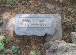

Mary Theresa Sturgis Powell
| Birth | : | 1 Jun 1836 Conneaut Center, Crawford County, Pennsylvania, USA |
| Death | : | 30 Dec 1904 Clay County, Kansas, USA |
| Burial | : | Sherman Cemetery, Morganville, Clay County, USA |
| Coordinate | : | 39.5316300, -97.2243700 |
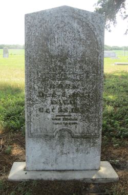
| Description | : | THE FUNERAL OF MRS. MARY POWELL WAS HELD FROM THE HOME SUNDAY AT ONE O'CLOCK AND WAS SO LARGELY ATTENDED THE CHURCH WAS TO SMALL TO HOLD THE CROWD. REV. ZOOK OFFICIATED. MISS. MARY T. STURGES WAS BORN IN CRAWFORD COUNTY, PENN. JUNE 1, 1836 WHERE SHE RESIDED UNTIL HER PARENTS DEATH, WHICH ACCURED WHEN SHE WAS ELEVEN YEARS OLD. SHE THEN MOVED TO OHIO WHERE SHE UNITED IN MARRIAGE TO JOSEPH H WRIGHT, TO WHICH UNION FOUR CHILDREN WERE BORN. TWO OF WHOM DIED IN INFANCY. SHE WITH HER HUSBAND THEN REMOVED TO WISCONSIN WHERE SHE RESIDED UNTIL THE... Read More |
frequently asked questions (FAQ):
-
Where is Mary Theresa Sturgis Powell's memorial?
Mary Theresa Sturgis Powell's memorial is located at: Sherman Cemetery, Morganville, Clay County, USA.
-
When did Mary Theresa Sturgis Powell death?
Mary Theresa Sturgis Powell death on 30 Dec 1904 in Clay County, Kansas, USA
-
Where are the coordinates of the Mary Theresa Sturgis Powell's memorial?
Latitude: 39.5316300
Longitude: -97.2243700
Family Members:
Spouse
Children
Flowers:


Nearby Cemetories:
1. Sherman Cemetery
Morganville, Clay County, USA
Coordinate: 39.5316300, -97.2243700
2. Norwegian Lutheran Cemetery
Clay Center, Clay County, USA
Coordinate: 39.5027900, -97.1828200
3. Riverdale Cemetery
Clay County, USA
Coordinate: 39.5106010, -97.2930984
4. Morganville City Cemetery
Morganville, Clay County, USA
Coordinate: 39.4733009, -97.1819000
5. Swedish Evangelical Lutheran Cemetery
Clay County, USA
Coordinate: 39.4911700, -97.1455100
6. Garfield Center Mission Cemetery
Clay Center, Clay County, USA
Coordinate: 39.5243100, -97.1277500
7. Bloom Cemetery
Morganville, Clay County, USA
Coordinate: 39.4519005, -97.2778015
8. Swedish Pleasant Hill Cemetery
Clay Center, Clay County, USA
Coordinate: 39.4735985, -97.1268997
9. Idylwilde Cemetery
Clay Center, Clay County, USA
Coordinate: 39.5097900, -97.0713000
10. Lincoln Cemetery
Clay Center, Clay County, USA
Coordinate: 39.4230995, -97.2930984
11. Iwacura Cemetery
Morganville, Clay County, USA
Coordinate: 39.4550000, -97.3510000
12. Hayes Cemetery
Clay County, USA
Coordinate: 39.4516983, -97.0811005
13. Saint Joseph Cemetery
Saint Joseph, Cloud County, USA
Coordinate: 39.5074941, -97.4022328
14. Cedar Grove Cemetery
Clyde, Cloud County, USA
Coordinate: 39.5494003, -97.4056015
15. Joseph Sender Family Cemetery
Clay County, USA
Coordinate: 39.5090600, -97.0348800
16. Greenwood Cemetery
Clay Center, Clay County, USA
Coordinate: 39.4011002, -97.1275024
17. Saint Peter and Saint Pauls Catholic Cemetery
Clay Center, Clay County, USA
Coordinate: 39.4005450, -97.1236680
18. Wilson Cemetery
Clay County, USA
Coordinate: 39.3800011, -97.1896973
19. Brethren in Christ Cemetery
Clay County, USA
Coordinate: 39.4810982, -97.0344009
20. Mount Calvary Cemetery
Clyde, Cloud County, USA
Coordinate: 39.5917015, -97.4143982
21. Mount Hope Cemetery
Clyde, Cloud County, USA
Coordinate: 39.5969009, -97.4116974
22. Goshen Central Cemetery
Clay Center, Clay County, USA
Coordinate: 39.5099983, -97.0160980
23. Pleasant View Cemetery
Ames, Cloud County, USA
Coordinate: 39.5346985, -97.4431000
24. French Presbyterian Church Cemetery
Cloud County, USA
Coordinate: 39.4395200, -97.4148290