
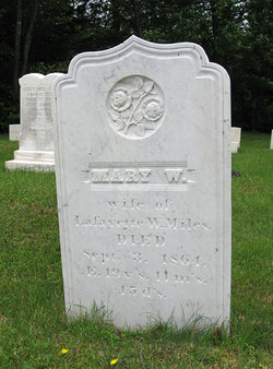
Mary W. Hinds Miles
| Birth | : | 19 Oct 1844 Stark, Coos County, New Hampshire, USA |
| Death | : | 3 Sep 1864 Stark, Coos County, New Hampshire, USA |
| Burial | : | Sunrise Memorial Gardens, Lithia Springs, Douglas County, USA |
| Coordinate | : | 33.7867012, -84.6956024 |
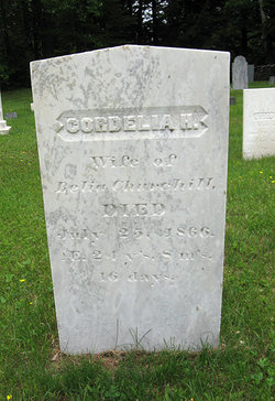
| Inscription | : | MARY W. wife of Lafayette W. Miles DIED Sept. 3, 1864, AE. 19y's. 11m's. 15 d's. |
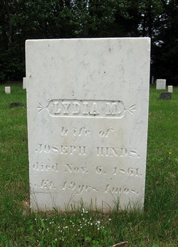
| Description | : | Mary was the daughter of Joseph Hinds and Lydia M. Rowell. Between the 1860 Stark census and her 1864 death she married Lafayette Washington Miles, son of Josiah Miles and Abigail Stalbird. She died before she was 20. I can't find a marriage record or death record for her. Her brother Amasa Hinds gave her information to the North America Family Histories. They didn't have any children. Her husband, Lafayette, married in Fond du Lac, WI on May 6, 1867 to Arabell Kendall, daughter of Charles Davis Kendall and Melissa Blanchard. Their children were Lilly May, Clarence, twins Charles & Clara Bell, George... Read More |
frequently asked questions (FAQ):
-
Where is Mary W. Hinds Miles's memorial?
Mary W. Hinds Miles's memorial is located at: Sunrise Memorial Gardens, Lithia Springs, Douglas County, USA.
-
When did Mary W. Hinds Miles death?
Mary W. Hinds Miles death on 3 Sep 1864 in Stark, Coos County, New Hampshire, USA
-
Where are the coordinates of the Mary W. Hinds Miles's memorial?
Latitude: 33.7867012
Longitude: -84.6956024
Family Members:
Parent
Spouse
Siblings
Flowers:


Nearby Cemetories:
1. Sunrise Memorial Gardens
Lithia Springs, Douglas County, USA
Coordinate: 33.7867012, -84.6956024
2. Ben Hill Road Cemetery
Lithia Springs, Douglas County, USA
Coordinate: 33.7932200, -84.6912400
3. Beulah Baptist Church Cemetery
Douglas County, USA
Coordinate: 33.7795000, -84.7037900
4. Forsyth Family Cemetery
Douglasville, Douglas County, USA
Coordinate: 33.7769220, -84.7055930
5. Union Grove Baptist Church Cemetery
Lithia Springs, Douglas County, USA
Coordinate: 33.7971530, -84.6797000
6. Roberts Cemetery
Douglas County, USA
Coordinate: 33.7555660, -84.6998690
7. Stone Family Cemetery
Lithia Springs, Douglas County, USA
Coordinate: 33.7778900, -84.6553120
8. Sharpton Family Cemetery
Douglas County, USA
Coordinate: 33.7769890, -84.7365890
9. County Line Baptist Church Cemetery
Lithia Springs, Douglas County, USA
Coordinate: 33.7564210, -84.6734280
10. Liberty Grove Cemetery
Douglasville, Douglas County, USA
Coordinate: 33.7515910, -84.6811150
11. Old Salt Springs Cemetery
Lithia Springs, Douglas County, USA
Coordinate: 33.7922180, -84.6479780
12. Pleasant Hill Baptist Church Cemetery
Powder Springs, Cobb County, USA
Coordinate: 33.8189011, -84.7244034
13. Community Church Cemetery
Austell, Cobb County, USA
Coordinate: 33.8086014, -84.6532974
14. Causey Chapel Cemetery
Austell, Cobb County, USA
Coordinate: 33.8083000, -84.6528015
15. McKenney Cemetery
Cobb County, USA
Coordinate: 33.8147011, -84.6583023
16. Old Smith Hill Cemetery
Austell, Cobb County, USA
Coordinate: 33.8089480, -84.6519790
17. Mozley Memorial Gardens
Lithia Springs, Douglas County, USA
Coordinate: 33.7738410, -84.6464820
18. Bowden Family Cemetery
Lithia Springs, Douglas County, USA
Coordinate: 33.7967670, -84.6453300
19. Mount Carmel Primitive Baptist Church Cemetery
Douglasville, Douglas County, USA
Coordinate: 33.7416600, -84.6823700
20. Pepper Family Cemetery
Douglas County, USA
Coordinate: 33.7412030, -84.6818960
21. Fair View Church Cemetery
Douglasville, Douglas County, USA
Coordinate: 33.7367760, -84.6971520
22. Cannon Family Cemetery
Lithia Springs, Douglas County, USA
Coordinate: 33.7678720, -84.6373600
23. Rose Hill Cemetery
Austell, Cobb County, USA
Coordinate: 33.8074989, -84.6382980
24. Liberty Methodist Episcopal Church Cemetery
Douglasville, Douglas County, USA
Coordinate: 33.7543530, -84.7486210