

Mary Wilson Miller
| Birth | : | 10 Dec 1837 |
| Death | : | 26 Feb 1931 |
| Burial | : | St John the Baptist Churchyard, East Markham, Bassetlaw District, England |
| Coordinate | : | 53.2457870, -0.8877260 |
| Plot | : | 114 |
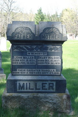
| Description | : | Mary was born in North Burgess Township, Lanark County, Ontario, the daughter of John Wilson and Mary Forgie. In June of 1856 she was married to John Miller, son of John Miller and Sarah McLelland, also of North Burgess. Mary died in Balderson, Ontario, at the home of her daughter, Mrs. J.C. McGregor. ---------------------------------- Plot 114 : - In memory of, - FATHER - John Miller, Born Nov.15,1835, died April 15,1926. - MOTHER - Mary Wilson, born Dec.10,1837, died Feb.26,1931 - Their daughter Isabellar, Born Nov.2,1867, died Sept.27,1881 |
frequently asked questions (FAQ):
-
Where is Mary Wilson Miller's memorial?
Mary Wilson Miller's memorial is located at: St John the Baptist Churchyard, East Markham, Bassetlaw District, England.
-
When did Mary Wilson Miller death?
Mary Wilson Miller death on 26 Feb 1931 in
-
Where are the coordinates of the Mary Wilson Miller's memorial?
Latitude: 53.2457870
Longitude: -0.8877260
Family Members:
Spouse
Children

Flowers:


Nearby Cemetories:
1. St John the Baptist Churchyard
East Markham, Bassetlaw District, England
Coordinate: 53.2457870, -0.8877260
2. St Nicholas Churchyard
Tuxford, Bassetlaw District, England
Coordinate: 53.2312300, -0.8979000
3. Tuxford Cemetery
Tuxford, Bassetlaw District, England
Coordinate: 53.2271830, -0.8925790
4. Church of All Saints Graveyard
West Markham, Bassetlaw District, England
Coordinate: 53.2463000, -0.9203000
5. All Saints Churchyard
West Markham, Bassetlaw District, England
Coordinate: 53.2462040, -0.9203580
6. St Nicholas Churchyard
Askham, Bassetlaw District, England
Coordinate: 53.2668010, -0.8922380
7. Milton Mausoleum Churchyard
Newark and Sherwood District, England
Coordinate: 53.2492330, -0.9297590
8. St Giles Churchyard
Darlton, Bassetlaw District, England
Coordinate: 53.2543300, -0.8339000
9. St Paul's Churchyard
West Drayton, Bassetlaw District, England
Coordinate: 53.2649300, -0.9352100
10. St. Peter's Churchyard
East Drayton, Bassetlaw District, England
Coordinate: 53.2691900, -0.8387700
11. St. Peter's Churchyard
Gamston, Bassetlaw District, England
Coordinate: 53.2765100, -0.9385900
12. All Saints Churchyard
Weston, Newark and Sherwood District, England
Coordinate: 53.2035930, -0.8425490
13. St. Peter's Churchyard
Stokeham, Bassetlaw District, England
Coordinate: 53.2835800, -0.8279800
14. St Leonards Churchyard
Ragnall, Bassetlaw District, England
Coordinate: 53.2540200, -0.7993100
15. St Matthew's Churchyard
Normanton-on-Trent, Bassetlaw District, England
Coordinate: 53.2124500, -0.8172600
16. St Michael the Archangel Churchyard
Laxton, Newark and Sherwood District, England
Coordinate: 53.1958110, -0.9208850
17. Holy Trinity Churchyard
Kirton, Newark and Sherwood District, England
Coordinate: 53.2170600, -0.9666600
18. All Saints Churchyard
Eaton, Bassetlaw District, England
Coordinate: 53.2939500, -0.9359600
19. Brotts Road Cemetery
Normanton-on-Trent, Bassetlaw District, England
Coordinate: 53.2092038, -0.8128064
20. St. Gregory Churchyard
Fledborough, Bassetlaw District, England
Coordinate: 53.2406090, -0.7847320
21. St Wilfrid's Churchyard
Marnham, Bassetlaw District, England
Coordinate: 53.2155000, -0.7933000
22. St. Matthew Parish Churchyard
Boughton, Newark and Sherwood District, England
Coordinate: 53.2089100, -0.9855900
23. St. John the Baptist Churchyard
Treswell, Bassetlaw District, England
Coordinate: 53.3057600, -0.8285600
24. All Hallows Churchyard
Ordsall, Bassetlaw District, England
Coordinate: 53.3096650, -0.9443470