
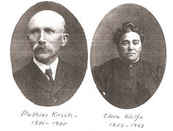
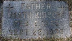
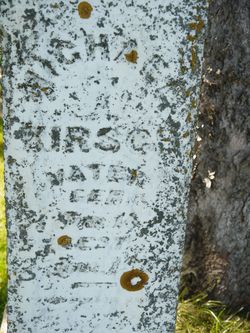
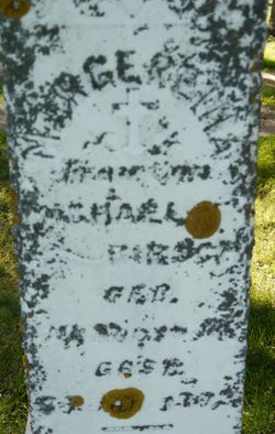
Mathias Kirsch
| Birth | : | 2 Feb 1855 Canach, Canton de Remich, Grevenmacher, Luxembourg |
| Death | : | 22 Sep 1935 Watertown, Codington County, South Dakota, USA |
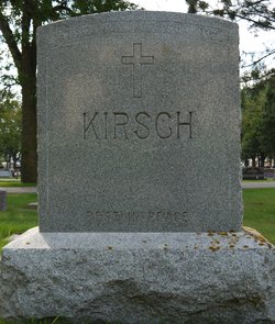
| Burial | : | Netherlands American Cemetery and Memorial, Margraten, Eijsden-Margraten Municipality, Netherlands |
| Coordinate | : | 50.8176918, 5.8046441 |
| Description | : | Math came to St. Charles, MN, with his family in 1879. In 1881 he took up a homestead near Waverly, SD. In 1911 he moved to a farm near Watertown. The 1920 census shows he and Clara living on their farm with their sons Matt and Frank. After 1923 he lived in Watertown at 310 2nd St. N.E., where he died of cancer. His death certificate stated that he was born in 1858. Math and Clara are both buried in St. Mary Cemetery in Watertown. |
frequently asked questions (FAQ):
-
Where is Mathias Kirsch's memorial?
Mathias Kirsch's memorial is located at: Netherlands American Cemetery and Memorial, Margraten, Eijsden-Margraten Municipality, Netherlands.
-
When did Mathias Kirsch death?
Mathias Kirsch death on 22 Sep 1935 in Watertown, Codington County, South Dakota, USA
-
Where are the coordinates of the Mathias Kirsch's memorial?
Latitude: 50.8176918
Longitude: 5.8046441
Family Members:
Parent
Spouse

Siblings
Children

Flowers:


Nearby Cemetories:
1. Netherlands American Cemetery and Memorial
Margraten, Eijsden-Margraten Municipality, Netherlands
Coordinate: 50.8176918, 5.8046441
2. Cadier en Keer Kerkhof
Cadier en Keer, Eijsden-Margraten Municipality, Netherlands
Coordinate: 50.8268600, 5.7695500
3. Begraafplaats Banholt
Banholt, Eijsden-Margraten Municipality, Netherlands
Coordinate: 50.7911800, 5.8139700
4. Reijmerstok Begraafplaats
Reijmerstok, Gulpen-Wittem Municipality, Netherlands
Coordinate: 50.7994500, 5.8407600
5. Algemene Begraafplaats
Valkenburg, Valkenburg aan de Geul Municipality, Netherlands
Coordinate: 50.8611100, 5.8248500
6. Oude Joodse Begraafplaats
Valkenburg, Valkenburg aan de Geul Municipality, Netherlands
Coordinate: 50.8613900, 5.8314100
7. Zusterbegraafplaats Rijckholt
Rijckholt, Eijsden-Margraten Municipality, Netherlands
Coordinate: 50.7961186, 5.7328002
8. Joodse Begraafplaats
Gulpen, Gulpen-Wittem Municipality, Netherlands
Coordinate: 50.8135290, 5.8865910
9. Wijlre Kerkhof
Wijlre, Gulpen-Wittem Municipality, Netherlands
Coordinate: 50.8315400, 5.8945100
10. Maastricht Oostermaas Cemetery
Maastricht, Maastricht Municipality, Netherlands
Coordinate: 50.8533700, 5.7224900
11. Begraafplaats Katholieke Kerk Heugem
Maastricht, Maastricht Municipality, Netherlands
Coordinate: 50.8315572, 5.7026935
12. Sint-Martens-Voeren Churchyard
Voeren, Arrondissement Tongeren, Belgium
Coordinate: 50.7492100, 5.8127200
13. Joodse Begraafplaats
Schimmert, Nuth Municipality, Netherlands
Coordinate: 50.8875400, 5.8149000
14. Kerkhof van Sint Pieter Op de Berg
Sint Pieter, Maastricht Municipality, Netherlands
Coordinate: 50.8313511, 5.6929176
15. Joodse Begraafplaats Meerssen
Meerssen Municipality, Netherlands
Coordinate: 50.8800900, 5.7473400
16. Joodse Begraafplaats
Eijsden-Margraten Municipality, Netherlands
Coordinate: 50.7760600, 5.7065700
17. Lanaye Communal Cemetery
Visé, Arrondissement de Liège, Belgium
Coordinate: 50.7819100, 5.6966500
18. Begraafplaats R.K. Parochie H Remigius
Klimmen, Voerendaal Municipality, Netherlands
Coordinate: 50.8764108, 5.8855418
19. Mechelen Kerkhof Cemetery
Mechelen, Gulpen-Wittem Municipality, Netherlands
Coordinate: 50.7964000, 5.9256700
20. Kanne Cemetery
Riemst, Arrondissement Tongeren, Belgium
Coordinate: 50.8143100, 5.6774900
21. Basiliek van Sint Servaas
Maastricht, Maastricht Municipality, Netherlands
Coordinate: 50.8487670, 5.6871100
22. Mechelen Kerk Begraafplaats apex
Mechelen, Gulpen-Wittem Municipality, Netherlands
Coordinate: 50.7981500, 5.9282700
23. R.K. Begraafplaats
Eys, Gulpen-Wittem Municipality, Netherlands
Coordinate: 50.8260056, 5.9327850
24. Belgische Oorlogsbegraafplaats Kanne
Riemst, Arrondissement Tongeren, Belgium
Coordinate: 50.8101400, 5.6682500