
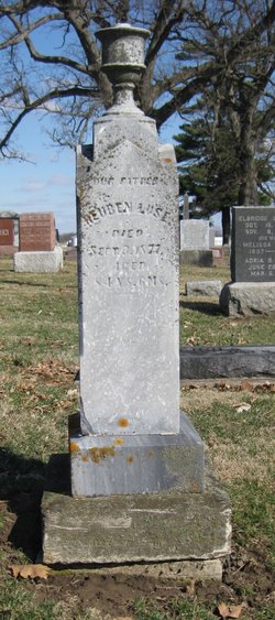
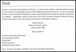
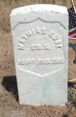
Mathias Luse II
| Birth | : | 18 Sep 1798 Washington County, Pennsylvania, USA |
| Death | : | 30 Oct 1877 White County, Indiana, USA |
| Burial | : | Christs Church Churchyard, Dawsmere, South Holland District, England |
| Coordinate | : | 52.8493100, 0.1398000 |
| Description | : | Parents: Mathias & Susannah Stark Luse Children: Priscilla, William Harvey, John, Daniel, Joseph, Francis, Mathias Jr, Nancy, James, Asa & Silvester Luse. |
frequently asked questions (FAQ):
-
Where is Mathias Luse II's memorial?
Mathias Luse II's memorial is located at: Christs Church Churchyard, Dawsmere, South Holland District, England.
-
When did Mathias Luse II death?
Mathias Luse II death on 30 Oct 1877 in White County, Indiana, USA
-
Where are the coordinates of the Mathias Luse II's memorial?
Latitude: 52.8493100
Longitude: 0.1398000
Family Members:
Parent
Spouse
Siblings
Children

Flowers:


Nearby Cemetories:
1. Christs Church Churchyard
Dawsmere, South Holland District, England
Coordinate: 52.8493100, 0.1398000
2. Gedney Drove End Churchyard
Gedney, South Holland District, England
Coordinate: 52.8493470, 0.1405420
3. Gedney Dawsmere Cemetery
Gedney, South Holland District, England
Coordinate: 52.8487200, 0.1428700
4. St Nicholas Churchyard
Lutton, South Holland District, England
Coordinate: 52.8085300, 0.1246500
5. St. Luke's Churchyard
Holbeach Hurn, South Holland District, England
Coordinate: 52.8231700, 0.0653600
6. St Mary Magdalene Churchyard
Gedney, South Holland District, England
Coordinate: 52.7984900, 0.0791600
7. Long Sutton Cemetery
Long Sutton, South Holland District, England
Coordinate: 52.7848300, 0.1272300
8. St. Mary's Churchyard
Long Sutton, South Holland District, England
Coordinate: 52.7844700, 0.1221800
9. Long Sutton Baptist Churchyard
Long Sutton, South Holland District, England
Coordinate: 52.7837460, 0.1204960
10. St. Mary Magdalene Churchyard
Fleet, South Holland District, England
Coordinate: 52.7928490, 0.0582900
11. Holbeach Cemetery
Holbeach, South Holland District, England
Coordinate: 52.8062100, 0.0171500
12. St. Matthew's Churchyard
Sutton Bridge, South Holland District, England
Coordinate: 52.7682100, 0.1903100
13. All Saints Churchyard
Holbeach, South Holland District, England
Coordinate: 52.8036140, 0.0142530
14. St. Mary Churchyard
Tydd St Mary, South Holland District, England
Coordinate: 52.7456600, 0.1404600
15. Whaplode Cemetery
Whaplode, South Holland District, England
Coordinate: 52.8016190, -0.0281347
16. Fosdyke Village Cemetery
Fosdyke, Boston Borough, England
Coordinate: 52.8808330, -0.0447220
17. All Saints Churchyard
Fosdyke, Boston Borough, England
Coordinate: 52.8811100, -0.0469440
18. St. Mary's Churchyard
Whaplode, South Holland District, England
Coordinate: 52.7974840, -0.0385520
19. St. Giles' Churchyard
Tydd St Giles, Fenland District, England
Coordinate: 52.7269470, 0.1118120
20. Walpole St Andrew
Walpole, Kings Lynn and West Norfolk Borough, England
Coordinate: 52.7349520, 0.2227630
21. Walpole St Andrew - Extension
Walpole, Kings Lynn and West Norfolk Borough, England
Coordinate: 52.7314600, 0.2162800
22. Terrington Saint Clement Methodist Cemetery
Terrington St Clement, Kings Lynn and West Norfolk Borough, England
Coordinate: 52.7589440, 0.2899360
23. St. Peter's Churchyard
Walpole, Kings Lynn and West Norfolk Borough, England
Coordinate: 52.7284200, 0.2219100
24. St Clement Churchyard
Terrington St Clement, Kings Lynn and West Norfolk Borough, England
Coordinate: 52.7593100, 0.2975600