

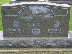
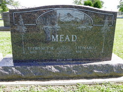
Maurice H Mead
| Birth | : | 9 May 1927 Cherry Valley, Ashtabula County, Ohio, USA |
| Death | : | 25 Mar 2014 Andover, Ashtabula County, Ohio, USA |
| Burial | : | Woodbine Cemetery and Mausoleum, Oceanport, Monmouth County, USA |
| Coordinate | : | 40.3011017, -74.0294037 |
| Description | : | March 27, 2014 Maurice H. Mead Star Beacon ANDOVER — Maurice H. "Gramps" Mead, age 86, of Andover, Ohio, died Tuesday, March 25, 2014, at his home. He was born May 9, 1927, in Cherry Valley Township, Ohio, a son of Myrlen Lomis and Winifred Irene (Mills) Mead. A resident of Andover since 1950, Mr. Mead was a 1945 graduate of New Lyme Deming School. He owned and operated dairy and grain farms in Cherry Valley and Andover for 64 years. He was a member of the Williamsfield United Methodist Church, where he served as a liturgist. He also was... Read More |
frequently asked questions (FAQ):
-
Where is Maurice H Mead's memorial?
Maurice H Mead's memorial is located at: Woodbine Cemetery and Mausoleum, Oceanport, Monmouth County, USA.
-
When did Maurice H Mead death?
Maurice H Mead death on 25 Mar 2014 in Andover, Ashtabula County, Ohio, USA
-
Where are the coordinates of the Maurice H Mead's memorial?
Latitude: 40.3011017
Longitude: -74.0294037
Family Members:
Parent

Spouse
Siblings
Children
Flowers:


Nearby Cemetories:
1. Glenwood Cemetery
West Long Branch, Monmouth County, USA
Coordinate: 40.2947006, -74.0269012
2. Congregation Brothers of Israel Cemetery Annex
West Long Branch, Monmouth County, USA
Coordinate: 40.3009033, -74.0190964
3. Monmouth Fields Cemetery
West Long Branch, Monmouth County, USA
Coordinate: 40.2989200, -74.0143900
4. Greenlawn Cemetery
West Long Branch, Monmouth County, USA
Coordinate: 40.2988892, -74.0143738
5. Congregation Brothers Of Israel Cemetery
West Long Branch, Monmouth County, USA
Coordinate: 40.2998619, -74.0133362
6. Slocum Family Burying Ground
Long Branch, Monmouth County, USA
Coordinate: 40.2997700, -74.0127700
7. Old First Methodist Church Cemetery
West Long Branch, Monmouth County, USA
Coordinate: 40.2847214, -74.0178452
8. Mount Carmel Cemetery
West Long Branch, Monmouth County, USA
Coordinate: 40.2891998, -74.0102997
9. Locust Grove Cemetery
Eatontown, Monmouth County, USA
Coordinate: 40.2924309, -74.0535431
10. White Ridge Cemetery
Eatontown, Monmouth County, USA
Coordinate: 40.2863998, -74.0496979
11. Old Free Church Cemetery
West Long Branch, Monmouth County, USA
Coordinate: 40.2770844, -74.0177765
12. Saint Johns Memorial Garden
Little Silver, Monmouth County, USA
Coordinate: 40.3339091, -74.0326643
13. First Presbyterian Churchyard
Shrewsbury, Monmouth County, USA
Coordinate: 40.3240280, -74.0604477
14. Christ Church Episcopal Graveyard
Shrewsbury, Monmouth County, USA
Coordinate: 40.3236122, -74.0613174
15. Friends Meeting House Burial Ground
Shrewsbury, Monmouth County, USA
Coordinate: 40.3244438, -74.0611115
16. Fields Cemetery
Eatontown, Monmouth County, USA
Coordinate: 40.2849998, -74.0736008
17. Evergreen Cemetery
Little Silver, Monmouth County, USA
Coordinate: 40.3410492, -74.0413208
18. Wayside United Methodist Cemetery
Oakhurst, Monmouth County, USA
Coordinate: 40.2600300, -74.0695000
19. Chadwick Family Burial Ground
Red Bank, Monmouth County, USA
Coordinate: 40.3521042, -74.0509186
20. Rumson Burying Ground
Rumson, Monmouth County, USA
Coordinate: 40.3535995, -74.0149994
21. Drummond Cemetery
Wanamassa, Monmouth County, USA
Coordinate: 40.2459300, -74.0212800
22. Enslaved Black Burial Ground
Tinton Falls, Monmouth County, USA
Coordinate: 40.3175614, -74.1049500
23. Grover Burial Ground
Lincroft, Monmouth County, USA
Coordinate: 40.3384400, -74.0929900
24. Pine Brook Cemetery
Macedonia, Monmouth County, USA
Coordinate: 40.2801590, -74.1058655