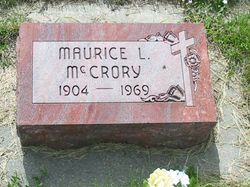
Maurice Leonard McCrory
| Birth | : | 6 Oct 1904 Cass County, Nebraska, USA |
| Death | : | 1 Jan 1969 Sherman County, Nebraska, USA |
| Burial | : | Rochdale Cemetery, Rochdale, Metropolitan Borough of Rochdale, England |
| Coordinate | : | 53.6132698, -2.1833401 |
| Description | : | Obituary. Grand Island Democrat. Thursday, January 2, 1969. EDUCATOR DIES; FUNERAL SATURDAY Ashton (Special Dispatch): -- A longtime Nebraska educator, Maurice L McCrory, 64, of Ashton, died Wednesday in his home. Funeral services will be at 10:30 AM Saturday at St. Francis Catholic Church in Ashton with Rev. Michael Szczesny officiating. Burial will be in the church cemetery. Rosary will be recited at 8 PM Friday at the Badura Funeral Home in Loup City. He was born October 6, 1904, to Iva C. and Maude McCrory, and graduated from Elmwood High School. Mr. McCrory recieved a bachelor's degree from Peru College and a master's degree in... Read More |
frequently asked questions (FAQ):
-
Where is Maurice Leonard McCrory's memorial?
Maurice Leonard McCrory's memorial is located at: Rochdale Cemetery, Rochdale, Metropolitan Borough of Rochdale, England.
-
When did Maurice Leonard McCrory death?
Maurice Leonard McCrory death on 1 Jan 1969 in Sherman County, Nebraska, USA
-
Where are the coordinates of the Maurice Leonard McCrory's memorial?
Latitude: 53.6132698
Longitude: -2.1833401
Family Members:
Parent
Spouse
Siblings
Children
Flowers:
Nearby Cemetories:
1. Rochdale Cemetery
Rochdale, Metropolitan Borough of Rochdale, England
Coordinate: 53.6132698, -2.1833401
2. Rochdale Crematorium
Rochdale, Metropolitan Borough of Rochdale, England
Coordinate: 53.6160820, -2.1830570
3. Denehurst Cemetery
Rochdale, Metropolitan Borough of Rochdale, England
Coordinate: 53.6206199, -2.1821104
4. Heywood Cemetery
Heywood, Metropolitan Borough of Rochdale, England
Coordinate: 53.6010610, -2.1931250
5. St. Paul's Churchyard
Norden, Metropolitan Borough of Rochdale, England
Coordinate: 53.6273006, -2.2126936
6. St Martin Churchyard
Castleton Moor, Metropolitan Borough of Rochdale, England
Coordinate: 53.5885050, -2.1756140
7. Christ Church Churchyard
Healey, Metropolitan Borough of Rochdale, England
Coordinate: 53.6378630, -2.1741198
8. St. James Ashworth
Rochdale, Metropolitan Borough of Rochdale, England
Coordinate: 53.6214693, -2.2261040
9. St. John's Churchyard Thornham
Middleton, Metropolitan Borough of Rochdale, England
Coordinate: 53.5760100, -2.1718300
10. St Bartholomew Churchyard
Whitworth, Rossendale Borough, England
Coordinate: 53.6553000, -2.1709700
11. St James the Apostle Churchyard
Wardle, Metropolitan Borough of Rochdale, England
Coordinate: 53.6497550, -2.1338420
12. Saint Andrew's
Dearnley, Metropolitan Borough of Rochdale, England
Coordinate: 53.6395100, -2.1168400
13. Littleborough Cemetery
Littleborough, Metropolitan Borough of Rochdale, England
Coordinate: 53.6407500, -2.1167500
14. Royton Cemetery
Royton, Metropolitan Borough of Oldham, England
Coordinate: 53.5727450, -2.1302850
15. St. Mary's Churchyard Birch-In-Hopwood
Heywood, Metropolitan Borough of Rochdale, England
Coordinate: 53.5662410, -2.2247560
16. St. Thomas Churchyard
Newhey, Metropolitan Borough of Rochdale, England
Coordinate: 53.6019166, -2.0958889
17. Whitworth Cemetery
Whitworth, Rossendale Borough, England
Coordinate: 53.6671650, -2.1674750
18. Boarshaw Cemetery and Crematorium
Middleton, Metropolitan Borough of Rochdale, England
Coordinate: 53.5584100, -2.1773100
19. Middleton Cemetery and Crematorium
Middleton, Metropolitan Borough of Rochdale, England
Coordinate: 53.5574400, -2.1829200
20. Saint Paul Churchyard
Royton, Metropolitan Borough of Oldham, England
Coordinate: 53.5653330, -2.1261450
21. Crompton Cemetery
Shaw, Metropolitan Borough of Oldham, England
Coordinate: 53.5799840, -2.1003410
22. St Matthew Churchyard
Chadderton, Metropolitan Borough of Oldham, England
Coordinate: 53.5565975, -2.1528452
23. Old Burial Grounds
Middleton, Metropolitan Borough of Rochdale, England
Coordinate: 53.5534036, -2.1948053
24. St Leonard's Churchyard
Middleton, Metropolitan Borough of Rochdale, England
Coordinate: 53.5530640, -2.1945060


