
| Birth | : | 13 Jan 1917 Chelan, Chelan County, Washington, USA |
| Death | : | 21 Sep 2012 Sunnyside, Yakima County, Washington, USA |
| Burial | : | Lower Valley Memorial Gardens, Sunnyside, Yakima County, USA |
| Coordinate | : | 46.3450012, -120.0117035 |
| Plot | : | Sunset Veteran 92 # 2 |
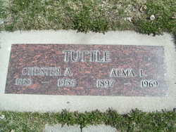
| Description | : | Maxine Maria Stevens passed away Friday, September 21, 2012 at age 95. She was born in Chelan WA to Chester and Alma Tuttle and lived the house her Father built at 220 West Gibson Avenue. Her Grandparents were Mr. and Mrs. Baly J. Tuttle and Mr. and Mrs. Charles Rubin. She spent many hours riding the Tuttle Brothers' boats on Lake Chelan and living on their houseboat in Stehekin. She and her family were dedicated members of St. Andrew's Episcopal Church. During her school years at Chelan High School, she was active in entertaining through singing and playing the piano... Read More |
frequently asked questions (FAQ):
-
Where is Maxine Maria Tuttle Stevens's memorial?
Maxine Maria Tuttle Stevens's memorial is located at: Lower Valley Memorial Gardens, Sunnyside, Yakima County, USA.
-
When did Maxine Maria Tuttle Stevens death?
Maxine Maria Tuttle Stevens death on 21 Sep 2012 in Sunnyside, Yakima County, Washington, USA
-
Where are the coordinates of the Maxine Maria Tuttle Stevens's memorial?
Latitude: 46.3450012
Longitude: -120.0117035
Family Members:
Parent

Spouse

Siblings
Flowers:


Nearby Cemetories:
1. Lower Valley Memorial Gardens
Sunnyside, Yakima County, USA
Coordinate: 46.3450012, -120.0117035
2. Holy Trinity Episcopal Close
Sunnyside, Yakima County, USA
Coordinate: 46.3235000, -120.0158500
3. Outlook Cemetery
Yakima, Yakima County, USA
Coordinate: 46.3208008, -120.0811005
4. Grandview Cemetery
Grandview, Yakima County, USA
Coordinate: 46.2658005, -119.8902969
5. Mabton Cemetery
Mabton, Yakima County, USA
Coordinate: 46.2285995, -119.9852982
6. Smohalla Cemetery
Toppenish, Yakima County, USA
Coordinate: 46.3009660, -120.2186250
7. Black Rock Cemetery
Moxee City, Yakima County, USA
Coordinate: 46.5111084, -119.9985962
8. Zillah German Baptist Cemetery
Zillah, Yakima County, USA
Coordinate: 46.4128550, -120.2506400
9. McCoy Cemetery
Toppenish, Yakima County, USA
Coordinate: 46.3835983, -120.2755966
10. Zillah Cemetery
Zillah, Yakima County, USA
Coordinate: 46.4055202, -120.2726072
11. Prosser Pioneer Cemetery
Prosser, Benton County, USA
Coordinate: 46.1947937, -119.8095245
12. Winnier Cemetery
Toppenish, Yakima County, USA
Coordinate: 46.3590060, -120.3192450
13. Elmwood Cemetery
Toppenish, Yakima County, USA
Coordinate: 46.3673830, -120.3334530
14. Prosser Cemetery
Prosser, Benton County, USA
Coordinate: 46.2047539, -119.7541504
15. Glade Cemetery
Yakima County, USA
Coordinate: 46.0778008, -120.0914001
16. Smina Cemetery
Yakima County, USA
Coordinate: 46.2372017, -120.4269028
17. Beaver Cemetery
Yakima County, USA
Coordinate: 46.0993996, -120.2866974
18. Holy Rosary Cemetery
Moxee City, Yakima County, USA
Coordinate: 46.5531006, -120.3585968
19. Holland Cemetery
Moxee City, Yakima County, USA
Coordinate: 46.5766983, -120.3861008
20. Meninick Cemetery
Yakima County, USA
Coordinate: 46.1981010, -120.4741974
21. Evergreen Cemetery
Benton City, Benton County, USA
Coordinate: 46.2867012, -119.4938965
22. Union Gap Cemetery
Yakima County, USA
Coordinate: 46.5209084, -120.4850998
23. Reservation Community Memorial Park
Wapato, Yakima County, USA
Coordinate: 46.4484291, -120.5375519
24. Toweatmy Cemetery
Toppenish, Yakima County, USA
Coordinate: 46.1794014, -120.5056000