

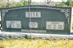
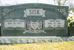
Meda Lorine Cantrell Sisk
| Birth | : | 9 Dec 1908 Myrtle, Oregon County, Missouri, USA |
| Death | : | 29 Jan 1990 Springfield, Greene County, Missouri, USA |
| Burial | : | Myrtle Cemetery, Myrtle, Oregon County, USA |
| Coordinate | : | 36.5133900, -91.2664300 |
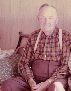
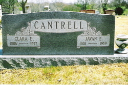
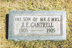
| Description | : | Daughter of Javan Eddie Cantrell and Clara Edith (Sorrell) Cantrell. Married Rev. Joseph Sisk 25/Sep/1927 at Myrtle, MO. ~~~~~ Meda Lorine Sisk, daughter of the late Javan Cantrell and Clara Sorrell Cantrell, was born December 9, 1908 in Myrtle, MO and departed this life January 29, 1990 in Springfield, MO at the age of 81 years, 1 month, and 20 days. She was united in marriage September 25, 1927 in Myrtle, MO to Reverend Joe Sisk who preceded her in death February 24, 1970. She is survived by one daughter, Mary Combs and her husband, Charles of Myrtle, MO; one son, Henry Sisk and his... Read More |
frequently asked questions (FAQ):
-
Where is Meda Lorine Cantrell Sisk's memorial?
Meda Lorine Cantrell Sisk's memorial is located at: Myrtle Cemetery, Myrtle, Oregon County, USA.
-
When did Meda Lorine Cantrell Sisk death?
Meda Lorine Cantrell Sisk death on 29 Jan 1990 in Springfield, Greene County, Missouri, USA
-
Where are the coordinates of the Meda Lorine Cantrell Sisk's memorial?
Latitude: 36.5133900
Longitude: -91.2664300
Family Members:
Parent
Spouse
Siblings

Children


Nearby Cemetories:
1. Myrtle Cemetery
Myrtle, Oregon County, USA
Coordinate: 36.5133900, -91.2664300
2. Church of God Cemetery
Oregon County, USA
Coordinate: 36.5023500, -91.2580200
3. Byrd Cemetery
Myrtle, Oregon County, USA
Coordinate: 36.5186005, -91.3143997
4. Crass Homestead
Myrtle, Oregon County, USA
Coordinate: 36.5359695, -91.3084671
5. Old Elmore Thomas field
Billmore, Oregon County, USA
Coordinate: 36.5237770, -91.1980250
6. Spring Valley Cemetery
Billmore, Oregon County, USA
Coordinate: 36.5324670, -91.2003420
7. Guiteau-Risner Cemetery
Guiteau, Oregon County, USA
Coordinate: 36.5588074, -91.3156128
8. Walnut Grove Cemetery
Elm Store, Randolph County, USA
Coordinate: 36.4914017, -91.1967010
9. O'Neal
Billmore, Oregon County, USA
Coordinate: 36.5712170, -91.2415410
10. Cotton Creek Cemetery
Jobe, Oregon County, USA
Coordinate: 36.5844002, -91.2652969
11. John Brown Cemetery
Jobe, Oregon County, USA
Coordinate: 36.5812111, -91.2953568
12. James Cemetery
Randolph County, USA
Coordinate: 36.4660988, -91.3435974
13. Old Jobe Cemetery
Jobe, Oregon County, USA
Coordinate: 36.5917015, -91.2517014
14. Mount Carmel Cemetery
Calm, Oregon County, USA
Coordinate: 36.5106010, -91.1643982
15. Taylor Cemetery
Ravenden Springs, Randolph County, USA
Coordinate: 36.4468994, -91.3293991
16. Garfield Cemetery
Garfield, Oregon County, USA
Coordinate: 36.5844400, -91.3253400
17. Mosely Cemetery
Randolph County, USA
Coordinate: 36.4460983, -91.1975021
18. Davis Cemetery
Sharp County, USA
Coordinate: 36.4606018, -91.3574982
19. Reynolds Cemetery
Elm Store, Randolph County, USA
Coordinate: 36.4491997, -91.1860962
20. Pigman Mound Archeological Site
Calm, Oregon County, USA
Coordinate: 36.5717100, -91.1784800
21. Stubblefield Cemetery
Dalton, Randolph County, USA
Coordinate: 36.4597015, -91.1718979
22. Bellah Cemetery
Ravenden Springs, Randolph County, USA
Coordinate: 36.4207993, -91.2825012
23. Arytown Cemetery
Arytown, Oregon County, USA
Coordinate: 36.5539513, -91.3795776
24. Liberty Cemetery
Calm, Oregon County, USA
Coordinate: 36.5586500, -91.1549600