
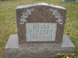
Melba Elliott
| Birth | : | 1913 |
| Death | : | 15 Nov 2003 |
| Burial | : | Pease Cemetery, Ellsworth, Grafton County, USA |
| Coordinate | : | 43.8741100, -71.7382000 |
| Description | : | Photo compliments of Eleanor Stump A World War II nurse from Calhoun County who helped treat causalities from Iwo Jima and Okinawa has died. Ninety-year-old Melba Elliott, formerly of Millstone, died November 15, 2003 in St. Joseph Hospital in Parkersburg. Funeral services are scheduled for 2 p.m. Tuesday at Stump Funeral Home in Arnoldsburg with Evangelist Corley Miller officiating. Visitation is from noon Tuesday until time of the service. Burial will be in the Barr Cemetery at Millstone. A graduate of Calhoun County High School, she attended nursing school at Camden-Clark in Parkersburg, and worked at the Gouvenor Hospital in New York. She entered the... Read More |
frequently asked questions (FAQ):
-
Where is Melba Elliott's memorial?
Melba Elliott's memorial is located at: Pease Cemetery, Ellsworth, Grafton County, USA.
-
When did Melba Elliott death?
Melba Elliott death on 15 Nov 2003 in
-
Where are the coordinates of the Melba Elliott's memorial?
Latitude: 43.8741100
Longitude: -71.7382000
Family Members:
Parent

Siblings


Flowers:


Nearby Cemetories:
1. Pease Cemetery
Ellsworth, Grafton County, USA
Coordinate: 43.8741100, -71.7382000
2. Old Baptist Church Cemetery
Ellsworth, Grafton County, USA
Coordinate: 43.8738890, -71.7430560
3. Avery Cemetery
Ellsworth, Grafton County, USA
Coordinate: 43.8805600, -71.7511200
4. West Campton Cemetery
Grafton County, USA
Coordinate: 43.8622220, -71.7052780
5. Partridge Hill Cemetery
West Campton, Grafton County, USA
Coordinate: 43.8428700, -71.7046900
6. Blake Cemetery
Stinson Lake, Grafton County, USA
Coordinate: 43.8827780, -71.7975000
7. Yeaton Cemetery
Thornton, Grafton County, USA
Coordinate: 43.8963800, -71.6794500
8. Blake Mountain Cemetery
Thornton, Grafton County, USA
Coordinate: 43.8963600, -71.6794200
9. West Thornton Cemetery
Thornton, Grafton County, USA
Coordinate: 43.8997200, -71.6805600
10. East Rumney
Rumney, Grafton County, USA
Coordinate: 43.8236110, -71.7483330
11. Town Line Cemetery
Campton, Grafton County, USA
Coordinate: 43.8614570, -71.6678870
12. Pine Grove Cemetery
Thornton, Grafton County, USA
Coordinate: 43.9060100, -71.6689000
13. Campton Village Cemetery
Campton, Grafton County, USA
Coordinate: 43.8654440, -71.6364380
14. Beech Hill Burying Ground
Campton, Grafton County, USA
Coordinate: 43.8000620, -71.7119690
15. Bog Road Cemetery
Campton, Grafton County, USA
Coordinate: 43.8152149, -71.6666793
16. Blaisdell Cemetery
Campton, Grafton County, USA
Coordinate: 43.8169440, -71.6555560
17. Blair Cemetery
Campton, Grafton County, USA
Coordinate: 43.8111000, -71.6603012
18. Rumney Cemetery
Rumney, Grafton County, USA
Coordinate: 43.8026100, -71.8037800
19. Campton Hollow Cemetery
Campton Hollow, Grafton County, USA
Coordinate: 43.8238150, -71.6409440
20. Highland Cemetery
Rumney, Grafton County, USA
Coordinate: 43.8020400, -71.8041500
21. Immanuel Memorial Cemetery
Rumney, Grafton County, USA
Coordinate: 43.7991670, -71.8077780
22. Mad River Cemetery
Thornton, Grafton County, USA
Coordinate: 43.8833670, -71.6077500
23. Rumney Depot Cemetery
Rumney, Grafton County, USA
Coordinate: 43.7957800, -71.8201500
24. Pleasant Valley Cemetery
Plymouth, Grafton County, USA
Coordinate: 43.7741300, -71.7364600