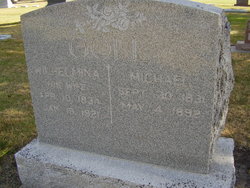
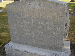
Michael Goll
| Birth | : | 30 Sep 1831 |
| Death | : | 4 May 1892 |
| Burial | : | Zion Cemetery, Port Hope, Northumberland County, Canada |
| Coordinate | : | 43.9694646, -78.4395690 |
| Plot | : | SW section Lot 73 |
| Description | : | Last Wednesday Coroner Schenck was called four miles southeast of Blue Hill to hold an inquest on the body of Michael Goll who had died the previous day. The jury decided that his death was the result of heart failure and other natural causes. He returned from Blue Hill Monday evening while his wife remained in that city. Tuesday morning he returned to bed and requested the boys to let him rest. At noon he seemed to be sleeping and at night he was dead. 13 May 1892 Red Cloud Chief Page 5 |
frequently asked questions (FAQ):
-
Where is Michael Goll's memorial?
Michael Goll's memorial is located at: Zion Cemetery, Port Hope, Northumberland County, Canada.
-
When did Michael Goll death?
Michael Goll death on 4 May 1892 in
-
Where are the coordinates of the Michael Goll's memorial?
Latitude: 43.9694646
Longitude: -78.4395690
Family Members:
Spouse
Children
Flowers:
Nearby Cemetories:
1. Zion Cemetery
Port Hope, Northumberland County, Canada
Coordinate: 43.9694646, -78.4395690
2. Wesleyville Cemetery
Wesleyville, Northumberland County, Canada
Coordinate: 43.9259810, -78.4156070
3. Lakeview Cemetery
Newtonville, Durham Regional Municipality, Canada
Coordinate: 43.9373400, -78.4983700
4. Walker Cemetery
Welcome, Northumberland County, Canada
Coordinate: 43.9698540, -78.3611440
5. Elizabethville Methodist Cemetery
Port Hope, Northumberland County, Canada
Coordinate: 44.0395370, -78.4613550
6. Canton Cemetery
Canton, Northumberland County, Canada
Coordinate: 43.9963400, -78.3465700
7. Welcome United Church Cemetery
Welcome, Northumberland County, Canada
Coordinate: 43.9630100, -78.3279900
8. Perrytown Presbyterian Cemetery
Perrytown, Northumberland County, Canada
Coordinate: 44.0408200, -78.3849000
9. Saint Pauls Anglican Church Cemetery
Perrytown, Northumberland County, Canada
Coordinate: 44.0423520, -78.3785500
10. Saint Mary's Cemetery
Port Hope, Northumberland County, Canada
Coordinate: 43.9579500, -78.3201900
11. Port Hope Union Cemetery
Port Hope, Northumberland County, Canada
Coordinate: 43.9564000, -78.3178700
12. Saint John's Anglican Church Cemetery
Port Hope, Northumberland County, Canada
Coordinate: 43.9558800, -78.3169100
13. Knoxville Presbyterian Church Cemetery
Port Hope, Northumberland County, Canada
Coordinate: 44.0341060, -78.3378510
14. Port Hope Pioneer Presbyterian Cemetery
Port Hope, Northumberland County, Canada
Coordinate: 43.9534350, -78.3030130
15. Lawrence Cemetery
Orono, Durham Regional Municipality, Canada
Coordinate: 43.9793555, -78.5795895
16. Saint Mark's Anglican Church Cemetery
Port Hope, Northumberland County, Canada
Coordinate: 43.9515220, -78.2898270
17. Bond Head Cemetery
Newcastle, Durham Regional Municipality, Canada
Coordinate: 43.9021840, -78.5746440
18. Bethel Methodist Cemetery
Clarke, Durham Regional Municipality, Canada
Coordinate: 43.9353950, -78.5978240
19. Providence Cemetery
Port Hope, Northumberland County, Canada
Coordinate: 44.0568300, -78.3161300
20. Orono Cemetery
Orono, Durham Regional Municipality, Canada
Coordinate: 43.9868200, -78.6174700
21. Bethel Grove Cemetery
Hamilton Township, Northumberland County, Canada
Coordinate: 44.0295120, -78.2786530
22. Lovekin Pioneer Cemetery
Lovekin, Durham Regional Municipality, Canada
Coordinate: 43.9024500, -78.6065900
23. Saint George's Anglican Church Cemetery
Newcastle, Durham Regional Municipality, Canada
Coordinate: 43.9136110, -78.6219440
24. Lawrence Back Church Cemetery
Clarke, Durham Regional Municipality, Canada
Coordinate: 44.0017800, -78.6591900

