

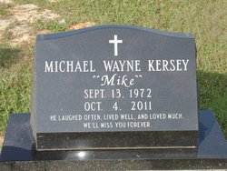
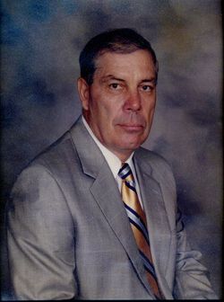
Michael Wayne “Mike” Kersey
| Birth | : | 13 Sep 1972 Lancaster County, South Carolina, USA |
| Death | : | 4 Oct 2011 |
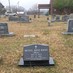
| Burial | : | Antioch Baptist Church Cemetery, Antioch, Lancaster County, USA |
| Coordinate | : | 34.7053185, -80.6746674 |
| Description | : | LANCASTER - Mr. Michael Wayne "Mike" Kersey, 39, of 1574 Dirt Road, died Tuesday, Oct. 4, 2011, at Carolinas Medical Center. He was born Sept. 13, 1972, in Lancaster County, the son of Marvin Wayne Kersey and Faye Johnson Kersey and was the husband of Erin Rushing Kersey. Mr. Kersey was a physical education teacher at Indian Land Elementary School and a wrestling coach for Indian Land High School. He earned a Bachelor's Degree in Physical Education, a Master's Degree in Early Childhood Development and a Master's Degree in Educational Administration, all from the University of S.C., and was a member... Read More |
frequently asked questions (FAQ):
-
Where is Michael Wayne “Mike” Kersey's memorial?
Michael Wayne “Mike” Kersey's memorial is located at: Antioch Baptist Church Cemetery, Antioch, Lancaster County, USA.
-
When did Michael Wayne “Mike” Kersey death?
Michael Wayne “Mike” Kersey death on 4 Oct 2011 in
-
Where are the coordinates of the Michael Wayne “Mike” Kersey's memorial?
Latitude: 34.7053185
Longitude: -80.6746674
Family Members:
Parent
Flowers:


Nearby Cemetories:
1. Antioch Baptist Church Cemetery
Antioch, Lancaster County, USA
Coordinate: 34.7053185, -80.6746674
2. Pleasant Dale Baptist Church Cemetery
Pleasant Dale, Lancaster County, USA
Coordinate: 34.7319740, -80.6920230
3. Gills Creek Cemetery
Lancaster County, USA
Coordinate: 34.7300000, -80.7047000
4. Hopewell United Methodist Church Cemetery
Lancaster, Lancaster County, USA
Coordinate: 34.7385150, -80.6498510
5. High Point Baptist Church Cemetery
Lancaster County, USA
Coordinate: 34.6875660, -80.6322620
6. Centenniel A.M.E. Zion Church Cemetery
Lancaster, Lancaster County, USA
Coordinate: 34.7082970, -80.7257430
7. Shaver Family Cemetery
Elgin, Lancaster County, USA
Coordinate: 34.6794680, -80.7173810
8. County Home Cemetery
Lancaster, Lancaster County, USA
Coordinate: 34.7232400, -80.7258500
9. Rich Hill Baptist Church Cemetery
Lancaster County, USA
Coordinate: 34.6596090, -80.6561480
10. New Zion Missionary Baptist Church Cemetery
Lancaster County, USA
Coordinate: 34.7207100, -80.6185490
11. Saint Luke UMC Cemetery
Lancaster, Lancaster County, USA
Coordinate: 34.6728310, -80.7204780
12. New Hope AME Zion Church Cemetery
Lancaster, Lancaster County, USA
Coordinate: 34.7569220, -80.6586460
13. Buford Battleground Memorial
Buford, Lancaster County, USA
Coordinate: 34.7427410, -80.6274600
14. Pleasant Grove Baptist Church Cemetery
Heath Springs, Lancaster County, USA
Coordinate: 34.6551700, -80.6500370
15. Mount Calvary AME Zion Church Cemetery
Lancaster County, USA
Coordinate: 34.6586740, -80.7130700
16. Camp Creek Baptist Church Cemetery
Lancaster, Lancaster County, USA
Coordinate: 34.7592720, -80.6943690
17. Fellowship Bible Church
Lancaster, Lancaster County, USA
Coordinate: 34.6914920, -80.7422720
18. Canaan Land Ministries Church Cemetery
Lancaster, Lancaster County, USA
Coordinate: 34.7177500, -80.6052000
19. Union Baptist Church Cemetery
Lancaster County, USA
Coordinate: 34.7191280, -80.5989050
20. Bethlehem Baptist Church Cemetery
Lancaster County, USA
Coordinate: 34.7592350, -80.6315860
21. Fork Hill Cemetery
Fork Hill Crossroads, Lancaster County, USA
Coordinate: 34.6535988, -80.6205978
22. Baskins Cemetery
Lancaster County, USA
Coordinate: 34.6397018, -80.6505966
23. New Cut Memorial Cemetery
Lancaster, Lancaster County, USA
Coordinate: 34.7803640, -80.6744440
24. Saint Paul Methodist Cemetery
Lancaster, Lancaster County, USA
Coordinate: 34.7231800, -80.7654770