


Mildred E Yost Fredricks
| Birth | : | 4 Oct 1917 Adams County, Nebraska, USA |
| Death | : | 1 Mar 2007 Hastings, Adams County, Nebraska, USA |
| Burial | : | St. Mary's Churchyard, Bridgwater, Sedgemoor District, England |
| Coordinate | : | 51.1277430, -3.0050330 |
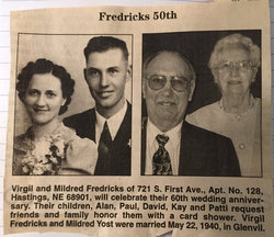
| Description | : | Hastings resident Mildred E. Fredricks, 89, of Good Samaritan Village Goldbeck Towers died Thursday, March 1, 2007, at Perkins Pavilion in Hastings. Services were held Monday at Immanuel Lutheran Church in Glenvil with Pastor Jeff Glawe officiating. Burial was in Glenvil Cemetery at Glenvil. *** Mrs. Fredricks was born October 4, 1917, in Adams County to John P. and Barbara (Schluening) Yost. She graduated from Hastings High School and attended Hastings College. She taught in rural country schools for 3 years. On May 22, 1940, she married Virgil Fredricks in Glenvil. She was a homemaker... Read More |
frequently asked questions (FAQ):
-
Where is Mildred E Yost Fredricks's memorial?
Mildred E Yost Fredricks's memorial is located at: St. Mary's Churchyard, Bridgwater, Sedgemoor District, England.
-
When did Mildred E Yost Fredricks death?
Mildred E Yost Fredricks death on 1 Mar 2007 in Hastings, Adams County, Nebraska, USA
-
Where are the coordinates of the Mildred E Yost Fredricks's memorial?
Latitude: 51.1277430
Longitude: -3.0050330
Family Members:
Parent
Spouse
Siblings
Children

Flowers:


Nearby Cemetories:
1. St. Mary's Churchyard
Bridgwater, Sedgemoor District, England
Coordinate: 51.1277430, -3.0050330
2. Bridgwater Baptist Church
Bridgwater, Sedgemoor District, England
Coordinate: 51.1272613, -3.0046282
3. Gray Friar's
Bridgwater, Sedgemoor District, England
Coordinate: 51.1264260, -3.0065160
4. Quaker Burial Ground
Bridgwater, Sedgemoor District, England
Coordinate: 51.1261740, -3.0078020
5. Former Holy Trinity Churchyard
Bridgwater, Sedgemoor District, England
Coordinate: 51.1261850, -3.0021850
6. Wembdon Road Cemetery
Bridgwater, Sedgemoor District, England
Coordinate: 51.1280877, -3.0138897
7. St John The Baptist Churchyard
Bridgwater, Sedgemoor District, England
Coordinate: 51.1311160, -2.9969910
8. St George Churchyard
Wembdon, Sedgemoor District, England
Coordinate: 51.1364420, -3.0171170
9. St. John Bristol Road Cemetery
Bridgwater, Sedgemoor District, England
Coordinate: 51.1391470, -2.9901660
10. Quantock Road Cemetery
Bridgwater, Sedgemoor District, England
Coordinate: 51.1284270, -3.0285630
11. Holy Trinity Churchyard
Chilton Trinity, Sedgemoor District, England
Coordinate: 51.1474390, -3.0072360
12. St Hugh's Church
Durleigh, Sedgemoor District, England
Coordinate: 51.1198090, -3.0375260
13. Heathfield Cemetery
North Petherton, Sedgemoor District, England
Coordinate: 51.0957200, -3.0081100
14. St. Mary Parish Churchyard
North Petherton, Sedgemoor District, England
Coordinate: 51.0920790, -3.0149060
15. Church of the Blessed Virgin Mary Churchyard
Chedzoy, Sedgemoor District, England
Coordinate: 51.1344600, -2.9429400
16. Blessed Virgin Mary Churchyard
Cannington, Sedgemoor District, England
Coordinate: 51.1500970, -3.0622850
17. St Edward King and Martyr Churchyard
Goathurst, Sedgemoor District, England
Coordinate: 51.1034930, -3.0633930
18. Saint Michael & All Angels Churchyard
Bawdrip, Sedgemoor District, England
Coordinate: 51.1517260, -2.9429330
19. Cannington Cemetery
Cannington, Sedgemoor District, England
Coordinate: 51.1500620, -3.0697070
20. Saint Michael and All Angels Churchyard
Puriton, Sedgemoor District, England
Coordinate: 51.1706000, -2.9735000
21. Westonzoyland Cemetery New
Westonzoyland, Sedgemoor District, England
Coordinate: 51.1096271, -2.9349336
22. St. John The Baptist Churchyard
Pawlett, Sedgemoor District, England
Coordinate: 51.1789100, -3.0012650
23. The Old Chapel
Westonzoyland, Sedgemoor District, England
Coordinate: 51.1077425, -2.9285237
24. St. Mary's Churchyard
Westonzoyland, Sedgemoor District, England
Coordinate: 51.1087000, -2.9273800