
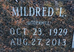

Mildred L “Mickie” Underhill Christie
| Birth | : | 23 Oct 1929 Morris County, Kansas, USA |
| Death | : | 27 Aug 2013 Salina, Saline County, Kansas, USA |
| Burial | : | Summit Cemetery, Jamestown, Cloud County, USA |
| Coordinate | : | 39.4813200, -97.8628800 |
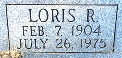
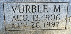
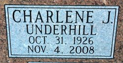
| Description | : | Mildred was born October 23, 1929 to Vurble and Loris R. Underhill, who precede her in death. She married the love of her life, William "Bill" Christie, August 27, 1947. She was preceded in death by her husband; William "Bill" G. Christie in 2009, sisters; June Chapman, Maxine Walters, Charlene Scherer and brother-in-law; James Scherer. Mildred is survived by her son; William "Vernon" Christie and wife Brenda; a brother; Ronald (Ginny) Underhill; one granddaughter; Connie Marie Beynon and great granddaughter; Samantha Lillian Beynon; along with many nieces and nephews. An inurnment was held at Summit Cemetery on Hwy 9 in Cloud County. |
frequently asked questions (FAQ):
-
Where is Mildred L “Mickie” Underhill Christie's memorial?
Mildred L “Mickie” Underhill Christie's memorial is located at: Summit Cemetery, Jamestown, Cloud County, USA.
-
When did Mildred L “Mickie” Underhill Christie death?
Mildred L “Mickie” Underhill Christie death on 27 Aug 2013 in Salina, Saline County, Kansas, USA
-
Where are the coordinates of the Mildred L “Mickie” Underhill Christie's memorial?
Latitude: 39.4813200
Longitude: -97.8628800
Family Members:
Parent
Spouse
Siblings
Flowers:


Nearby Cemetories:
1. Morrison Cemetery
Center Township, Cloud County, USA
Coordinate: 39.4817009, -97.7975006
2. Summit Cemetery #3
Macyville, Cloud County, USA
Coordinate: 39.5258330, -97.9194440
3. West Summit Cemetery
Jamestown, Cloud County, USA
Coordinate: 39.5532900, -97.8312600
4. West Asher Cemetery
Scottsville, Mitchell County, USA
Coordinate: 39.4815000, -97.9661600
5. Scottsville Cemetery
Scottsville, Mitchell County, USA
Coordinate: 39.5468102, -97.9474945
6. McBride Cemetery
Beloit, Mitchell County, USA
Coordinate: 39.4808006, -97.9907990
7. Asherville Cemetery
Asherville, Mitchell County, USA
Coordinate: 39.4205000, -97.9672900
8. Wilcox Cemetery
Cloud County, USA
Coordinate: 39.4925003, -97.7313995
9. West Branch Cemetery
Buffalo Township, Cloud County, USA
Coordinate: 39.5391998, -97.7457962
10. Bell-Bogardus Cemetery
Asherville, Mitchell County, USA
Coordinate: 39.4242410, -97.9919970
11. Jamestown Cemetery
Jamestown, Cloud County, USA
Coordinate: 39.5964012, -97.8839035
12. Saint Mary's Cemetery
Jamestown, Cloud County, USA
Coordinate: 39.5964012, -97.8850021
13. Smith Cemetery
Asherville, Mitchell County, USA
Coordinate: 39.4516690, -98.0098850
14. Hefner Cemetery
Cloud County, USA
Coordinate: 39.5393400, -97.7218400
15. Glasco Cemetery
Glasco, Cloud County, USA
Coordinate: 39.3574000, -97.8265000
16. Saint Marys Catholic Cemetery
Glasco, Cloud County, USA
Coordinate: 39.3574000, -97.8245000
17. Fairview Cemetery
Buffalo Township, Cloud County, USA
Coordinate: 39.5889015, -97.7724991
18. Hall Cemetery
Cloud County, USA
Coordinate: 39.4455986, -97.7033005
19. Simpson Cemetery
Simpson, Mitchell County, USA
Coordinate: 39.3633003, -97.9471970
20. West Hope Cemetery
Jewell County, USA
Coordinate: 39.5896988, -97.9871979
21. Saron Cemetery
Jamestown, Cloud County, USA
Coordinate: 39.6317240, -97.8377910
22. Lovseth Cemetery
Randall, Jewell County, USA
Coordinate: 39.6249000, -97.9685000
23. Saint Lukes Cemetery
Randall, Jewell County, USA
Coordinate: 39.6390000, -97.9325000
24. Kindel Cemetery
Center Township, Cloud County, USA
Coordinate: 39.4519005, -97.6464005