
| Birth | : | 8 Sep 1922 Leonard, Shelby County, Missouri, USA |
| Death | : | 26 Mar 2005 Columbia, Boone County, Missouri, USA |
| Burial | : | Elkins Memorial Gardens, Elkins, Randolph County, USA |
| Coordinate | : | 38.8838997, -79.8469009 |
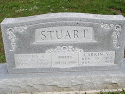
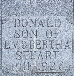
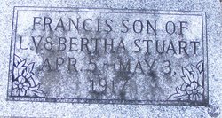
| Description | : | The Clarence Courier, Clarence, Shelby, Missouri, March 30, 2005. Luetta "Letty" Brown, age 82, of Shelbyville, passed away Saturday, March 26, 2005, at 6:00 p.m. in Boone Hospital Center at Columbia. She was born in Leonard, MO, on September 8, 1922, the daughter of Larkin Vandiver and Bertha Wand Stuart. She is survived by two children: Connie Ray of Shelbyville and Charles Brown and his wife, Dana, of Derby, KS; six grandchildren: Kelly Ray of Shelbyville, Kristi Ray of Columbia, Tiffany Blaske and husband, Steve, of Wichita, KS, Travis Brown and wife, Kyndra, of Wichita, KS, Matt and Nikki Martindale of Derby, KS;... Read More |
frequently asked questions (FAQ):
-
Where is Mildred Luetta “Letty” Stuart Brown's memorial?
Mildred Luetta “Letty” Stuart Brown's memorial is located at: Elkins Memorial Gardens, Elkins, Randolph County, USA.
-
When did Mildred Luetta “Letty” Stuart Brown death?
Mildred Luetta “Letty” Stuart Brown death on 26 Mar 2005 in Columbia, Boone County, Missouri, USA
-
Where are the coordinates of the Mildred Luetta “Letty” Stuart Brown's memorial?
Latitude: 38.8838997
Longitude: -79.8469009
Family Members:
Parent

Spouse
Siblings
Children

Flowers:


Nearby Cemetories:
1. Elkins Memorial Gardens
Elkins, Randolph County, USA
Coordinate: 38.8838997, -79.8469009
2. Chenoweth Hill Cemetery
Elkins, Randolph County, USA
Coordinate: 38.8792590, -79.8357770
3. Arnolds Hill Baptist Church Cemetery
Elkins, Randolph County, USA
Coordinate: 38.8863000, -79.8635000
4. Saint Brendan Catholic Cemetery
Elkins, Randolph County, USA
Coordinate: 38.9002991, -79.8442001
5. Ward Family Cemetery
Elkins, Randolph County, USA
Coordinate: 38.8956814, -79.8634269
6. Hazelwood Cemetery
Elkins, Randolph County, USA
Coordinate: 38.8597641, -79.8577118
7. Thomas Phillips Farm Cemetery
Beverly, Randolph County, USA
Coordinate: 38.8543472, -79.8824921
8. Mount Iser Confederate Cemetery
Beverly, Randolph County, USA
Coordinate: 38.8444500, -79.8666600
9. Beverly Cemetery
Beverly, Randolph County, USA
Coordinate: 38.8455200, -79.8726807
10. Waybright Cemetery #05
Franklin, Pendleton County, USA
Coordinate: 38.8646300, -79.7964600
11. Harper Cemetery
Pendleton County, USA
Coordinate: 38.8646300, -79.7964600
12. Park Cemetery
Beverly, Randolph County, USA
Coordinate: 38.8407560, -79.8369520
13. Butcher Family Cemetery
Beverly, Randolph County, USA
Coordinate: 38.8419500, -79.8672600
14. Hinkle Cemetery
Elkins, Randolph County, USA
Coordinate: 38.9317890, -79.8574520
15. Old Catholic Cemetery
Elkins, Randolph County, USA
Coordinate: 38.9335117, -79.8391259
16. Kelly Mountain Cemetery
Elkins, Randolph County, USA
Coordinate: 38.9013930, -79.7789460
17. Maplewood Cemetery
Elkins, Randolph County, USA
Coordinate: 38.9417000, -79.8510971
18. Bell Family Cemetery
Randolph County, USA
Coordinate: 38.8981480, -79.7708890
19. Trinity Cemetery
Beverly, Randolph County, USA
Coordinate: 38.8329440, -79.8920230
20. Mount Vernon Cemetery
Randolph County, USA
Coordinate: 38.8213300, -79.8482900
21. John M Stalnaker Cemetery
Beverly, Randolph County, USA
Coordinate: 38.8245470, -79.8731770
22. Little Arlington Cemetery
Elkins, Randolph County, USA
Coordinate: 38.9482994, -79.8308029
23. Mouse Cemetery
Elkins, Randolph County, USA
Coordinate: 38.9488370, -79.8299000
24. Whitman Ward Family Cemetery
Elkins, Randolph County, USA
Coordinate: 38.9444900, -79.8822330