


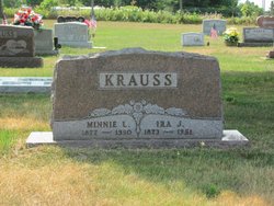
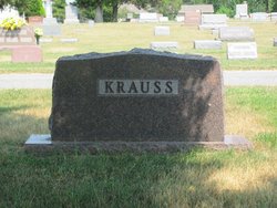


Minnie Lee Kimbrough Krauss
| Birth | : | 2 Jul 1877 Morristown, Hamblen County, Tennessee, USA |
| Death | : | 10 Jul 1950 Swanton, Fulton County, Ohio, USA |
| Burial | : | Epworth Municipal Cemetery, Epworth, North Lincolnshire Unitary Authority, England |
| Coordinate | : | 53.5206600, -0.8239000 |
| Description | : | Minnie L. (Kimbrough) Krauss was the daughter of John Andrew Sr. & Martha Jane Larimore Kimbrough. Minnie has 4 other children by Ira Krauss: Howard Elmo (changed his last name to Krause) 1910 - 1993 Heckard Francisco 1915-1912. FAG[15859531] Nana Pauline (Topping) 1918 - 2000 Elner Lucille "Lucy" (Croxton) 1921 - 2009 Suggested edit: Ira and Minnie Krauss had Five children; Howard Elmo Beulah Uida Heckard Francisco Nana Pauline Eleanor Lucile Contributor: Jennifer Krauss (50908450) |
frequently asked questions (FAQ):
-
Where is Minnie Lee Kimbrough Krauss's memorial?
Minnie Lee Kimbrough Krauss's memorial is located at: Epworth Municipal Cemetery, Epworth, North Lincolnshire Unitary Authority, England.
-
When did Minnie Lee Kimbrough Krauss death?
Minnie Lee Kimbrough Krauss death on 10 Jul 1950 in Swanton, Fulton County, Ohio, USA
-
Where are the coordinates of the Minnie Lee Kimbrough Krauss's memorial?
Latitude: 53.5206600
Longitude: -0.8239000
Family Members:
Parent
Spouse

Siblings
Children

Flowers:


Nearby Cemetories:
1. Epworth Municipal Cemetery
Epworth, North Lincolnshire Unitary Authority, England
Coordinate: 53.5206600, -0.8239000
2. St Andrew Churchyard
Epworth, North Lincolnshire Unitary Authority, England
Coordinate: 53.5256450, -0.8231740
3. All Saints Churchyard
Belton, North Lincolnshire Unitary Authority, England
Coordinate: 53.5478600, -0.8199200
4. Owston Ferry Cemetery
Owston Ferry, North Lincolnshire Unitary Authority, England
Coordinate: 53.4966300, -0.7827500
5. St Martin's Churchyard
Owston Ferry, North Lincolnshire Unitary Authority, England
Coordinate: 53.4933920, -0.7886380
6. St. Nicholas' Churchyard
Haxey, North Lincolnshire Unitary Authority, England
Coordinate: 53.4896400, -0.8489650
7. Baptist Burial Ground
West Butterwick, North Lincolnshire Unitary Authority, England
Coordinate: 53.5432720, -0.7423210
8. St Mary the Virgin Churchyard
West Butterwick, North Lincolnshire Unitary Authority, England
Coordinate: 53.5426407, -0.7412120
9. St Pancras Church
Wroot, North Lincolnshire Unitary Authority, England
Coordinate: 53.5158350, -0.9209990
10. St John The Baptist Churchyard Extension
Burringham, North Lincolnshire Unitary Authority, England
Coordinate: 53.5708230, -0.7439800
11. St Oswald Churchyard
Althorpe, North Lincolnshire Unitary Authority, England
Coordinate: 53.5765570, -0.7408910
12. Blessed Virgin Mary Churchyard
West Stockwith, Bassetlaw District, England
Coordinate: 53.4434410, -0.8117040
13. All Saints Churchyard
Misterton, Bassetlaw District, England
Coordinate: 53.4442500, -0.8500830
14. St. Peter's Churchyard
East Stockwith, West Lindsey District, England
Coordinate: 53.4415500, -0.8161400
15. Laughton Cemetery
Laughton, West Lindsey District, England
Coordinate: 53.4681287, -0.7228939
16. All Saints Churchyard
Laughton, West Lindsey District, England
Coordinate: 53.4656600, -0.7224400
17. St Oswald Churchyard
Crowle, North Lincolnshire Unitary Authority, England
Coordinate: 53.6077330, -0.8353940
18. Crowle Cemetery
Crowle, North Lincolnshire Unitary Authority, England
Coordinate: 53.6090660, -0.8285680
19. Crowle Baptist Church
Crowle, North Lincolnshire Unitary Authority, England
Coordinate: 53.6093970, -0.8317350
20. Scotter Cemetery
Scotter, West Lindsey District, England
Coordinate: 53.4942000, -0.6665520
21. St Peter Churchyard
Scotter, West Lindsey District, England
Coordinate: 53.4966600, -0.6636500
22. Holy Trinity Churchyard
Messingham, North Lincolnshire Unitary Authority, England
Coordinate: 53.5323250, -0.6583030
23. St. Martin de Tours Churchyard
Blyton, West Lindsey District, England
Coordinate: 53.4430280, -0.7169130
24. Walkeringham Parish Cemetery
Walkeringham, Bassetlaw District, England
Coordinate: 53.4201430, -0.8463880