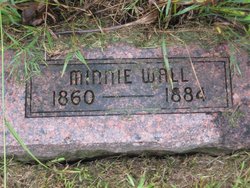
Minnie Lee Wall Currah
| Birth | : | 1860 Missouri, USA |
| Death | : | 1884 |
| Burial | : | Fork Ridge Cemetery, Claiborne County, USA |
| Coordinate | : | 36.5815560, -83.7991620 |
| Plot | : | 074OC plot 4 |
frequently asked questions (FAQ):
-
Where is Minnie Lee Wall Currah's memorial?
Minnie Lee Wall Currah's memorial is located at: Fork Ridge Cemetery, Claiborne County, USA.
-
When did Minnie Lee Wall Currah death?
Minnie Lee Wall Currah death on 1884 in
-
Where are the coordinates of the Minnie Lee Wall Currah's memorial?
Latitude: 36.5815560
Longitude: -83.7991620
Family Members:
Parent
Spouse
Siblings
Children
Flowers:
Nearby Cemetories:
1. Fork Ridge Cemetery
Claiborne County, USA
Coordinate: 36.5815560, -83.7991620
2. Middleton Cemetery
Fork Ridge, Claiborne County, USA
Coordinate: 36.5727420, -83.7798760
3. Fonde Church of God Mountain Assembly Cemetery
Fonde, Bell County, USA
Coordinate: 36.5924260, -83.8806440
4. Miracle Cemetery #4
Davisburg, Bell County, USA
Coordinate: 36.6117084, -83.7207006
5. Pruden-Fonde Cemetery
Fonde, Bell County, USA
Coordinate: 36.5945610, -83.8902570
6. Bruce Cemetery
Claiborne County, USA
Coordinate: 36.5252991, -83.7332993
7. Ball Cemetery
Bell County, USA
Coordinate: 36.6199972, -83.7113139
8. Marsee Cemetery
Bell County, USA
Coordinate: 36.5988890, -83.6986110
9. Carr Cemetery
Cumberland Gap, Claiborne County, USA
Coordinate: 36.5259900, -83.7121300
10. Webb Cemetery #3
Chenoa, Bell County, USA
Coordinate: 36.6552430, -83.8693540
11. Dennis Miracle Family Cemetery
Frakes, Bell County, USA
Coordinate: 36.6529130, -83.8778680
12. Bostic Cemetery
Claiborne County, USA
Coordinate: 36.5647011, -83.9175034
13. Johnson Cemetery
Clairfield, Claiborne County, USA
Coordinate: 36.5462800, -83.9153200
14. Kibert Cemetery
Arthur, Claiborne County, USA
Coordinate: 36.5381012, -83.6844025
15. Partin Cemetery #04
Chenoa, Bell County, USA
Coordinate: 36.6706100, -83.8623100
16. Billingsley Cemetery
Arthur, Claiborne County, USA
Coordinate: 36.5360800, -83.6842400
17. Branscombe Cemetery
Claiborne County, USA
Coordinate: 36.4810982, -83.8319016
18. Milford Partin Cemetery
Chenoa, Bell County, USA
Coordinate: 36.6661610, -83.8751040
19. Partin Cemetery #03
Chenoa, Bell County, USA
Coordinate: 36.6666985, -83.8752975
20. Chenoa Cemetery
Chenoa, Bell County, USA
Coordinate: 36.6758003, -83.8563995
21. Lee Cemetery
Davisburg, Bell County, USA
Coordinate: 36.6814003, -83.8424988
22. Powers Family Cemetery
Cumberland Gap, Claiborne County, USA
Coordinate: 36.5192700, -83.6919200
23. Underwood Grove Missionary Baptist Church Cemetery
Cumberland Gap, Claiborne County, USA
Coordinate: 36.5192700, -83.6918600
24. Taylor
Clairfield, Claiborne County, USA
Coordinate: 36.5698000, -83.9328600

