
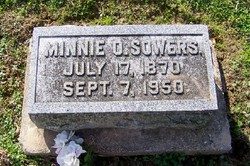
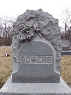
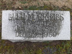
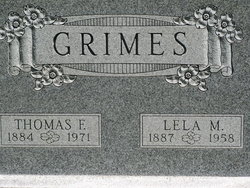
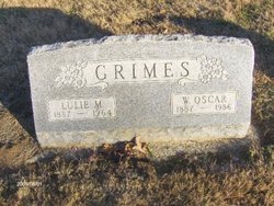
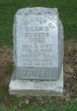
Minnie O Grimes Sowers
| Birth | : | 17 Jul 1870 |
| Death | : | 2 Sep 1950 |
| Burial | : | St. Cuthbert's Churchyard, Halsall, West Lancashire District, England |
| Coordinate | : | 53.5852140, -2.9529650 |
frequently asked questions (FAQ):
-
Where is Minnie O Grimes Sowers's memorial?
Minnie O Grimes Sowers's memorial is located at: St. Cuthbert's Churchyard, Halsall, West Lancashire District, England.
-
When did Minnie O Grimes Sowers death?
Minnie O Grimes Sowers death on 2 Sep 1950 in
-
Where are the coordinates of the Minnie O Grimes Sowers's memorial?
Latitude: 53.5852140
Longitude: -2.9529650
Family Members:
Parent
Spouse

Siblings
Children

Flowers:


Nearby Cemetories:
1. St. Cuthbert's Churchyard
Halsall, West Lancashire District, England
Coordinate: 53.5852140, -2.9529650
2. St. Mark Churchyard
Scarisbrick, West Lancashire District, England
Coordinate: 53.6134600, -2.9403800
3. St. Elizabeth's Churchyard
Scarisbrick, West Lancashire District, England
Coordinate: 53.6124460, -2.9206340
4. Southport Crematorium
Scarisbrick, West Lancashire District, England
Coordinate: 53.6235810, -2.9600210
5. Christ Churchyard
Aughton, West Lancashire District, England
Coordinate: 53.5583510, -2.9046990
6. St Thomas Churchyard
Lydiate, Metropolitan Borough of Sefton, England
Coordinate: 53.5443480, -2.9621640
7. St Peter and St Paul Churchyard
Ormskirk, West Lancashire District, England
Coordinate: 53.5692640, -2.8877690
8. Saint Anne's Roman Catholic Church Cemetery
Ormskirk, West Lancashire District, England
Coordinate: 53.5626520, -2.8935560
9. West Lancashire Cemetery and Crematorium
Burscough, West Lancashire District, England
Coordinate: 53.5875500, -2.8820300
10. Our Lady's Roman Catholic Churchyard
Lydiate, Metropolitan Borough of Sefton, England
Coordinate: 53.5396850, -2.9599940
11. Saint Michael's Churchyard
Aughton, West Lancashire District, England
Coordinate: 53.5419170, -2.9197240
12. St Catherine Churchyard
Lydiate, Metropolitan Borough of Sefton, England
Coordinate: 53.5368000, -2.9612660
13. Sacred Heart RC Cemetery
Birkdale, Metropolitan Borough of Sefton, England
Coordinate: 53.6066100, -3.0270100
14. Liverpool Road Cemetery
Birkdale, Metropolitan Borough of Sefton, England
Coordinate: 53.6083620, -3.0257140
15. Ardwick Cemetery
Ardwick, Metropolitan Borough of Manchester, England
Coordinate: 53.6302778, -2.9900000
16. Christ Church Churchyard
Southport, Metropolitan Borough of Sefton, England
Coordinate: 53.6327778, -2.9953770
17. St. Michael and All Angels Churchyard
Great Altcar, Metropolitan Borough of Sefton, England
Coordinate: 53.5507770, -3.0279540
18. Duke Street Cemetery
Southport, Metropolitan Borough of Sefton, England
Coordinate: 53.6343536, -2.9993131
19. Burscough Priory
Burscough, West Lancashire District, England
Coordinate: 53.5830270, -2.8565030
20. St. James Churchyard
Westhead, West Lancashire District, England
Coordinate: 53.5582324, -2.8527492
21. St John The Evangelist Roman Catholic Church
Burscough, West Lancashire District, England
Coordinate: 53.5902152, -2.8424163
22. St. Peter's Churchyard
Formby, Metropolitan Borough of Sefton, England
Coordinate: 53.5663834, -3.0594721
23. Our Lady Of Compassion RC Churchyard
Formby, Metropolitan Borough of Sefton, England
Coordinate: 53.5574060, -3.0575020
24. Friends Burial Ground
Bickerstaffe, West Lancashire District, England
Coordinate: 53.5347720, -2.8748780